
The Herzegovina-Neretva Canton is one of 10 cantons of the Federation of Bosnia and Herzegovina in Bosnia and Herzegovina.
Jablanica is a town and municipality located in Herzegovina-Neretva Canton of the Federation of Bosnia and Herzegovina, an entity of Bosnia and Herzegovina. It is situated on the Neretva river and Jablanica lake.

Prozor-Rama is a town and municipality located in Herzegovina-Neretva Canton of the Federation of Bosnia and Herzegovina, an entity of Bosnia and Herzegovina. Also, Ramsko jezero is located near the town.

Dobrunska Rijeka is a village in the municipality of Višegrad, Bosnia and Herzegovina.
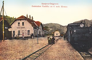
Donje Vardište is a village in the municipality of Višegrad, Bosnia and Herzegovina. It is on the border between Serbia and Bosnia and Herzegovina. Donje Vardište was one of the two end stations of the Bosnian Eastern Railway, which had been built from Sarajevo to Uvac and Vardište during the Austro-Hungarian rule in Bosnia and Herzegovina. Construction of the line started in 1903. It was completed in 1906, using the 760 mm track gauge. With the cost of 75 million gold crowns, which approximately translates to 450 thousand gold crowns per kilometer, it was one of the most expensive railways in the world built by that time. The line was eventually extended to Belgrade in 1928. Donje Vardište is today part of the narrow-gauge heritage railway Šargan Eight.
Drina is a village in the municipality of Višegrad, Bosnia and Herzegovina.
Faljenovići is a village in the municipality of Višegrad, Bosnia and Herzegovina.
Meremišlje is a village in the municipality of Višegrad, Bosnia and Herzegovina.

Višegradska Banja is a village in the municipality of Višegrad, Bosnia and Herzegovina.

Uloško Lake is a lake of Bosnia and Herzegovina. It is located in the municipality of Ulog.
Gvozno Lake is a quazi-natural lake in Bosnia and Herzegovina on the mountain Treskavica. It is located in the municipality of Kalinovik.
Jugovo Lake also known as Borilovačko Lake is a lake of Republika Srpska, Bosnia and Herzegovina. It is located in the municipality of Zelengora. The lake is about 250m long and 100m wide and contains Californian Trout.

Orlovačko Lake is a lake of Republika Srpska, Bosnia and Herzegovina. It is located in the municipality of Zelengora. The lake area is about 3.50 hectares, and has a maximum depth of about 5.50 metres (18.0 ft).

Gornje Bare is a lake of Republika Srpska, Bosnia and Herzegovina. It is located in the municipality of Zelengora.
Grabovičko Lake is an artificial lake of Bosnia and Herzegovina. It is located in the municipality of Jablanica.

Klinje Lake is an artificial lake of Bosnia and Herzegovina. It is located in the municipality of Gacko.
Tribistovo Lake is an artificial lake of Bosnia and Herzegovina. It is located in the municipality of Posusje.
Deransko Lake is a lake of Bosnia and Herzegovina. It is located in the municipality of Hutovo Blato.
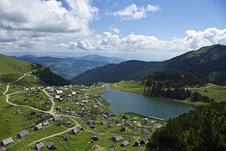
Prokoško Lake is a lake of Bosnia and Herzegovina. It is located in the municipality of Fojnica and it is 1670m above sea level.
Gatačko Polje is a karst field within the Gacko municipality in Bosnia and Herzegovina, spanning 57–60 km², being ca. 24 km long and ca. 3,6 km wide, in the northwest–southeast direction. It is situated between the mountains of Bjelašnica and Lebršnik on the altitude of 930 to 1000 m. The subterranean rivers of Gračanica and Mušnica cross the field. The only larger settlement is Gacko. Near the field are the mountains and straddle of Čemerno, the source of the Trebišnjica, Klinje Lake and the Sutjeska National Park. The field develops agriculture and animal husbandry.


