
Nelson is a city on the eastern shores of Tasman Bay / Te Tai-o-Aorere. Nelson is the oldest city in the South Island and the second-oldest settled city in New Zealand – it was established in 1841 and became a city by royal charter in 1858.
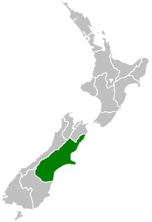
Canterbury is a region of New Zealand, located in the central-eastern South Island. The region covers an area of 44,503.88 square kilometres (17,183.04 sq mi), making it the largest region in the country by area. It is home to a population of 655,000.
Otago is a region of New Zealand located in the southern half of the South Island administered by the Otago Regional Council. It has an area of approximately 32,000 square kilometres (12,000 sq mi), making it the country's second largest local government region. Its population was 246,000 in June 2022.
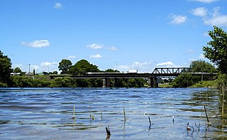
Ngāruawāhia is a town in the Waikato region of the North Island of New Zealand. It is located 20 kilometres (12 mi) north-west of Hamilton at the confluence of the Waikato and Waipā Rivers, adjacent to the Hakarimata Range. Ngāruawāhia is in the Hamilton Urban Area, the fourth largest urban area in New Zealand. The location was once considered as a potential capital of New Zealand.

Whanganui, also spelled Wanganui, is a city in the Manawatū-Whanganui region of New Zealand. The city is located on the west coast of the North Island at the mouth of the Whanganui River, New Zealand's longest navigable waterway. Whanganui is the 19th most-populous urban area in New Zealand and the second-most-populous in Manawatū-Whanganui, with a population of 42,600 as of June 2022.

Manawatū-Whanganui is a region in the lower half of the North Island of New Zealand, whose main population centres are the cities of Palmerston North and Whanganui. It is administered by the Manawatū-Whanganui Regional Council, which operates under the name Horizons Regional Council.

The Rangitīkei River is one of New Zealand's longest rivers, 253 kilometres (157 mi) long.
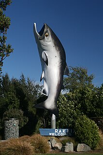
Rakaia is a town seated close to the southern banks of the Rakaia River on the Canterbury Plains in New Zealand's South Island, approximately 57 km south of Christchurch on State Highway 1 and the Main South Line. Immediately north of the township are New Zealand's longest road bridge and longest rail bridge, both of which cross the wide shingle beds of the braided river at this point. Both bridges are approximately 1750 metres in length.

The Chinook salmon is the largest and most valuable species of Pacific salmon in North America, as well as the largest in the genus Oncorhynchus. Its common name is derived from the Chinookan peoples. Other vernacular names for the species include king salmon, Quinnat salmon, Tsumen, spring salmon, chrome hog, Blackmouth, and Tyee salmon. The scientific species name is based on the Russian common name chavycha (чавыча).

The Whanganui River is a major river in the North Island of New Zealand. It is the country's third-longest river, and has special status owing to its importance to the region's Māori people. In March 2017 it became the world's second natural resource to be given its own legal identity, with the rights, duties and liabilities of a legal person. The Whanganui Treaty settlement brought the longest-running litigation in New Zealand history to an end.

The Waiau River is the largest river in the Southland region of New Zealand. 'Waiau' translates to 'River of Swirling Currents'. It is the outflow of Lake Te Anau, flowing from it into Lake Manapouri 10 kilometres (6 mi) to the south, and from there flows south for 70 kilometres (43 mi) before reaching the Foveaux Strait 8 kilometres (5 mi) south of Tuatapere. It also takes water from Lake Monowai.

The Tongariro River is a river in the North Island of New Zealand. The part of the Waikato River from the Waihohonu Stream, down to Lake Taupo, was formally named the Tongariro River in 1945. The river originates in the Central Plateau of the North Island where it is fed by numerous tributaries that flow off the surrounding hill ranges and mountains such as Mount Ruapehu. It then winds its way north, through the township of Turangi before entering Lake Taupo via a number of river mouths. The minimum volume of water flowing down the lower Tongariro River ranges from approximately 16 cubic metres per second (570 cu ft/s) to 21 cubic metres per second (740 cu ft/s). This volume can substantially increase due to catchment of rainfall by the surrounding mountains and hill ranges.

Mount Hale is a mountain located in Grafton County, New Hampshire. The mountain is named after Reverend Edward Everett Hale (1822–1909), and is part of the Twin Range of the White Mountains. The western and eastern sides of Mount Hale are drained by the Little River and Zealand River respectively, and thence into the Ammonoosuc River, Connecticut River, and into Long Island Sound in Connecticut.

The Avon River / Ōtākaro flows through the centre of the city of Christchurch, New Zealand, and out to an estuary, which it shares with the Ōpāwaho / Heathcote River, the Avon Heathcote Estuary / Ihutai.

The Westland temperate forests, also known as the Westland temperate rainforests, is a temperate broadleaf and mixed forests ecoregion located along the central west coast of New Zealand’s South Island, also known as Te Waipounamou. These forests are found in the region of the Westland District, which spans approximately 11,880 square kilometers. It is bounded on the west by the Tasman Sea, and on the east by the Southern Alps. Much of this area is protected by the Westland Tai Poutini National Park.
Mount Whitcombe is a mountain in New Zealand's Southern Alps, rising to a height of 2,650 metres (8,690 ft).

Lake Gault is a small glacial lake in South Westland, New Zealand, near the township of Fox Glacier. A walking track from Lake Matheson leads to the lake, which is surrounded by mature native forest. A small hydro-electric power plant was constructed piping water from the lake to power a gold mining dredge at Gillespies Beach. Endangered Ōkārito kiwi (rowi) have been released into the wild around Lake Gault.

Lake Wahapo is a small glacial lake in South Westland, New Zealand, within the Westland Tai Poutini National Park and near the township of Whataroa. It was a traditional mahinga kai for local Māori. State Highway 6 skirts the lake's southern shore. The lake discharges to the Ōkārito River via a small hydroelectric power station commissioned in 1960. The ecology of the lake has altered considerably since 1967, when the Waitangitāhuna River changed course to flow into the lake.

