Black Creek may refer to:

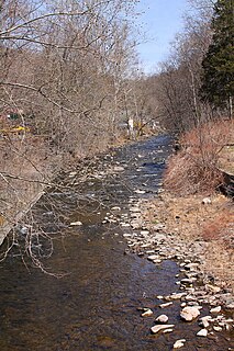
Bowman Creek is a tributary of the Susquehanna River in Luzerne County and Wyoming County, in Pennsylvania, in the United States. It is approximately 26 miles (42 km) long and flows through Ross Township and Lake Township in Luzerne County and Noxen Township, Monroe Township, and Eaton Township in Wyoming County. The watershed of the creek has an area of 120 square miles (310 km2). The creek is not designated as an impaired waterbody and its pH is close to neutral, although it has experienced some problems with acid rain. It has low concentrations of dissolved solids like calcium. The creek is relatively small in its upper reaches, but by Noxen, its width is 40 to 60 feet. It is also relatively shallow in many reaches. Rock formations in the watershed include the Catskill Formation, the Huntley Mountain Formation, Burgoon Sandstone, the Mauch Chunk Formation, the Pottsville Group, and the Pocono Formation. Soil associations in the creek's watershed include the Wellsboro-Morris-Oquaga association, the Oquaga-Lackawanna-Arnot association, the Mardin-Bath-Volusia association, and the Wyoming-Pope association.
Harveys Creek is a tributary of the Susquehanna River in Luzerne County, Pennsylvania, in the United States. It is approximately 14.5 miles (23.3 km) long and flows through Harveys Lake, Lake Township, Lehman Township, Jackson Township, and Plymouth Township. The creek's watershed has an area of 46.3 square miles (120 km2). The creek has four named tributaries, which are known as Bear Hollow Creek, Paint Spring Run, Pikes Creek, and East Fork Harveys Creek. The watershed is designated as a High-Quality Coldwater Fishery and a Migratory Fishery above Pikes Creek and as a Coldwater Fishery and a Migratory Fishery below it. The creek's source is Harveys Lake, the largest natural lake in Pennsylvania.

Black Creek is a long source tributary of Nescopeck Creek so part of the Susquehanna River drainage basin. It is also the second & longer stream of the same name recognized by the USGS GNIS system in Luzerne County, Pennsylvania, in the United States—compared to the Black Creek beyond the ridgeline of the drainage divide, so in the Lehigh River valley and Carbon County. The headwaters of both Black Creeks in Luzerne county are only a few miles apart, and both valleys were traversed by the Lausanne-Nescopeck Turnpike in the first half of the 19th-century.
Huntington Creek is a tributary of Fishing Creek in Luzerne and Columbia counties, Pennsylvania, in the United States. It is approximately 29.5 miles (47.5 km) long.

Pennsylvania Route 239 (PA 239) is a 36.84-mile-long (59.29 km) state highway located in Luzerne, Columbia and Lycoming Counties in Pennsylvania. The southern terminus is at PA 93 in Nescopeck Township. The northern terminus is at PA 42 in North Mountain. The route heads north from PA 93 and parallels the Susquehanna River between Wapwallopen and Mocanaqua before crossing the river into Shickshinny and forming a concurrency with U.S. Route 11 (US 11). Past Shickshinny, PA 239 runs west through rural areas to Benton, where it has a concurrency with PA 487. The route continues northwest and crosses PA 118 before it reaches its northern terminus.

Solomon Creek is a tributary of the Susquehanna River in Luzerne County, Pennsylvania, in the United States. It is approximately 8.8 miles (14.2 km) long and flows through Fairview Township, Hanover Township, and Wilkes-Barre. The creek is affected by acid mine drainage and has significant loads of iron, aluminum, and manganese. The creek's named tributaries are Spring Run, Sugar Notch Run, and Pine Creek. The Solomon Creek watershed is located in the Anthracite Valley section of the ridge-and-valley geographical province. Major rock formations in the watershed include the Mauch Chunk Formation, the Spechty Kopf Formation, and the Catskill Formation.
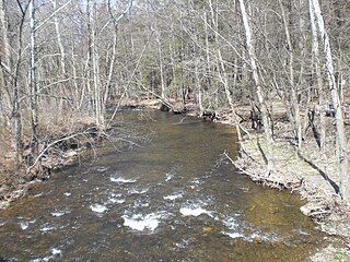
Shingle Run is a tributary of Huntington Creek in Luzerne County, Pennsylvania, in the United States. It is approximately 1.8 miles (2.9 km) long and flows through Ross Township. The watershed of the stream has an area of 1.83 square miles (4.7 km2) and it has no tributaries. The stream is considered to be Class A Wild Trout Waters for its entire length. Additionally, it is listed in the Luzerne County Natural Areas Inventory. Various species of butterfly inhabit the stream's vicinity. Trees in the area include hemlocks and yellow birches. The stream is small, but nevertheless is perennial.

Walker Run is a tributary of the Susquehanna River in Luzerne County, Pennsylvania, in the United States. It is approximately 4.4 miles (7.1 km) long and flows through Salem Township. The watershed of the stream has an area of 3.83 square miles (9.9 km2). There are three unnamed tributaries. The stream is on rock of the Mahantango Formation, the Harrell Formation, the Irish Valley Member, and the Trimmers Rock Formation. A number of roads cross the stream. It is inhabited by wild trout.
Bow Creek is a tributary of Big Wapwallopen Creek in Luzerne County, Pennsylvania, in the United States. It is approximately 4.5 miles (7.2 km) long and flows through Fairview Township and Wright Township. The watershed of the creek has an area of 4.69 square miles (12.1 km2). The creek has no named tributaries, but several unnamed ones, such as Bow Creek Tributary A. Bow Creek has been historically nearly devoid of life, but is now considered to be Class A Wild Trout Waters. There is a bridge carrying Pennsylvania Route 309 across the creek. Wisconsinan Till, alluvium, and bedrock consisting of sandstone, shale, conglomerate, and coal occur in the watershed. Several volatile organic compounds have been detected in small amounts in surface water in the watershed. The creek occasionally floods, but such flooding typically causes little damage.

Pond Creek is a tributary of Little Wapwallopen Creek in Luzerne County, Pennsylvania, in the United States. It is approximately 6.4 miles (10.3 km) long and flows through Slocum Township and Conyngham Township. The watershed of the creek has an area of 9.69 square miles (25.1 km2) and is part of the Lower North Branch Susquehanna drainage basin. A bridge was built over the creek in 1956. In the early 1900s, the Glen Brook Water Company planned to construct a dam on the creek. The surficial geology in the vicinity of Pond Creek includes Wisconsinan Till, alluvium, boulder alluvium, alluvial fan, and bedrock consisting of sandstone and shale, as well as some patches of wetland.

Nuangola Outlet is a tributary of Little Wapwallopen Creek in Luzerne County, Pennsylvania, in the United States. It is approximately 1.8 miles (2.9 km) long and flows through Rice Township. The watershed of the stream has an area of 2.35 square miles (6.1 km2). Wisconsinan Till and bedrock consisting of sandstone, shale, conglomerate, and coal occur in the watershed. There area also several lakes and patches of wetland. The stream was observed to have "excellent" water quality in the 1970s.
Rocky Run is a tributary of the Susquehanna River in Luzerne County, Pennsylvania, in the United States. It is approximately 2.3 miles (3.7 km) long and flows through Salem Township. The watershed of the stream has an area of 1.83 square miles (4.7 km2). In the early 1900s, the stream had a high level of water quality and was proposed for use as a water supply. The construction of a dam on it was proposed, but no formal plans were ever made. There are coal mines in the watershed, but they have been abandoned since the late 1800s. Wisconsinan Till, Wisconsinan Ice-Contact Stratified Drift, Boulder Colluvium, Wisconsinan Bouldery Till, coal dumps, and bedrock consisting of sandstone and shale all occur in the watershed. The drainage basin is designated as a Coldwater Fishery.

Turtle Creek is a tributary of the Susquehanna River in Luzerne County, Pennsylvania, in the United States. It is approximately 2.5 miles (4.0 km) long and flows through Conyngham Township. The watershed of the creek has an area of 1.59 square miles (4.1 km2). Wisconsinan Bouldery Till, Wisconsinan Ice-Contact Stratified Drift, Wisconsinan Outwash, alluvium, alluvial terrace, fill, and coal dumps all occur in the vicinity of the creek. The creek has been the subject of a flood protection project. Its watershed is designated as a Coldwater Fishery and a Migratory Fishery.

Hunlock Creek is a tributary of the Susquehanna River in Luzerne County, Pennsylvania, in the United States. It is approximately 7.8 miles (12.6 km) long and flows through Lehman Township and Hunlock Township. The watershed of the creek has an area of 32.5 square miles (84 km2) and is situated in northwestern Luzerne County. It has one named tributary, which is known as Roaring Brook, and a number of unnamed and unofficially named tributaries, such as "West Branch Hunlock Creek".

Toby Creek is a tributary of the Susquehanna River in Luzerne County, Pennsylvania, in the United States. It is approximately 10.5 miles (16.9 km) long and flows through Dallas Township, Dallas, Kingston Township, Courtdale, Luzerne, Pringle, Kingston, Edwardsville, and Larksville. The watershed of the creek has an area of 36.5 square miles (95 km2). The entire drainage basin is designated as a Migratory Fishery and parts are designated as either a Coldwater Fishery, a Warmwater Fishery, or a Trout Stocking Fishery. The creek has two named tributaries: Huntsville Creek and Trout Brook. It is said to show "some degraded conditions", but does not experience severe pollution and is not considered to be impaired. The creek is piped underground in Pringle, but resurfaces in Edwardsville.