Washington County, Virginia

Last updated

Washington County
WashingtonCountyVACourthouse.jpg
Washington County Courthouse
Flag of Washington County, Virginia.png
Washington County, Virginia seal.png
Map of Virginia highlighting Washington County.svg
Location within the U.S. state of Virginia
Virginia in United States.svg
Virginia's location within the U.S.
Coordinates: 36°43′N81°58′W / 36.72°N 81.96°W / 36.72; -81.96
CountryFlag of the United States.svg United States
StateFlag of Virginia.svg  Virginia
Founded1776
Named for George Washington
Seat Abingdon
Largest townAbingdon
Area
  Total566 sq mi (1,470 km2)
  Land561 sq mi (1,450 km2)
  Water5 sq mi (10 km2)  0.9%
Population
 (2020)
  Total53,935
  Density95/sq mi (37/km2)
Time zone UTC−5 (Eastern)
  Summer (DST) UTC−4 (EDT)
Congressional district 9th
Website www.washcova.com

Washington County is a county located in the Commonwealth of Virginia. As of the 2020 census, the population was 53,935. [1] Its county seat is Abingdon. [2]

Contents

Washington County is part of the KingsportBristolBristol, TN-VA Metropolitan Statistical Area, which is a component of the Johnson City–Kingsport–Bristol, TN-VA Combined Statistical Area, commonly known as the "Tri-Cities" region.

History

For thousands of years, indigenous peoples of varying cultures lived in the area. At the time of European encounter, the Chiska had a chief village near what is now Saltville, destroyed by the Spaniards in 1568. The Cherokee annexed the region from the Xualae around 1671, and ceded it to the Virginia Colony in 1770 at the Treaty of Lochaber.

The county was formed by Virginians in 1776 from Fincastle County. It was named for George Washington, who was then commander-in-chief of the Continental Army. Washington County is among the first geographical regions to be named after the president of the United States.

Washington County was raided by the Chickamauga Cherokee during the Cherokee–American wars. In July, 1776, Chief Dragging Canoe led an attack on Black's Fort (renamed Abingdon in 1778). The area remained prone to attack until after Chickamauga leader Bob Benge was finally slain by settlers in Washington County in 1794.

As with many other frontier counties, the boundaries and territory changed over the years. In 1786 the northwestern part of Washington County became Russell County. In 1814 the western part of what remained of Washington County was combined with parts of Lee and Russell counties to form Scott County. In 1832 the northeastern part of Washington was combined with part of Wythe County to form Smyth County. Finally, with the incorporation of the town of Goodson as the independent city of Bristol in 1890, Washington County assumed its present size.

A farm in Washington County, Virginia WashingtonCountyVA.jpg
A farm in Washington County, Virginia

Geography

According to the U.S. Census Bureau, the county has a total area of 566 square miles (1,470 km2), of which 561 square miles (1,450 km2) is land and 5 square miles (13 km2) (0.9%) is water. [3]

Districts

The county is divided into seven magisterial districts: Harrison, Jefferson, Madison, Monroe, Taylor, Tyler, and Wilson.

Adjacent counties

National protected areas

Major highways

Demographics

Historical population
CensusPop.Note
1790 5,625
1800 9,53669.5%
1810 12,15627.5%
1820 12,4442.4%
1830 15,61425.5%
1840 13,001−16.7%
1850 14,61212.4%
1860 16,89215.6%
1870 16,816−0.4%
1880 25,20349.9%
1890 29,02015.1%
1900 28,995−0.1%
1910 32,83013.2%
1920 32,376−1.4%
1930 33,8504.6%
1940 38,19712.8%
1950 37,536−1.7%
1960 38,0761.4%
1970 40,8357.2%
1980 46,48713.8%
1990 45,887−1.3%
2000 51,10311.4%
2010 54,8767.4%
2020 53,935−1.7%
U.S. Decennial Census [4]
1790-1960 [5] 1900-1990 [6]
2010 [7] 2020 [8]

2020 census

Washington County, Virginia - Demographic Profile
(NH = Non-Hispanic)
Race / EthnicityPop 2010 [7] Pop 2020 [8] % 2010% 2020
White alone (NH)52,79850,33896.21%93.33%
Black or African American alone (NH)6866511.25%1.21%
Native American or Alaska Native alone (NH)90910.16%0.17%
Asian alone (NH)2023340.37%0.62%
Pacific Islander alone (NH)600.01%0.00%
Some Other Race alone (NH)211340.04%0.25%
Mixed Race/Multi-Racial (NH)3491,4960.64%2.77%
Hispanic or Latino (any race)7248911.32%1.65%
Total54,87653,935100.00%100.00%

Note: the US Census treats Hispanic/Latino as an ethnic category. This table excludes Latinos from the racial categories and assigns them to a separate category. Hispanics/Latinos can be of any race.

2000 Census

As of the census [9] of 2000, there were 51,103 people, 21,056 households, and 14,949 families residing in the county. The population density was 91 inhabitants per square mile (35/km2). There were 22,985 housing units at an average density of 41 units per square mile (16 units/km2). The racial makeup of the county was 97.56% White, 1.32% Black or African American, 0.11% Native American, 0.27% Asian, 0.03% Pacific Islander, 0.14% from other races, and 0.58% from two or more races. 0.63% of the population were Hispanic or Latino of any race.

There were 21,056 households, out of which 28.10% had children under the age of 18 living with them, 59.10% were married couples living together, 8.70% had a female householder with no husband present, and 29.00% were non-families. 25.80% of all households were made up of individuals, and 10.40% had someone living alone who was 65 years of age or older. The average household size was 2.36 and the average family size was 2.84.

In the county, the population was spread out, with 20.80% under the age of 18, 8.70% from 18 to 24, 28.30% from 25 to 44, 26.90% from 45 to 64, and 15.30% who were 65 years of age or older. The median age was 40 years. For every 100 females, there were 94.20 males. For every 100 females aged 18 and over, there were 91.70 males.

The median income for a household in the county was $32,742, and the median income for a family was $40,162. Males had a median income of $30,104 versus $21,307 for females. The per capita income for the county was $18,350. About 8.10% of families and 10.90% of the population were below the poverty line, including 13.20% of those under age 18 and 14.20% of those age 65 or over.

Education

Colleges

Public high schools

Communities

Towns

Farmland in Washington County near Friendship and Wideners Valley ScenicWashingtonCoVa.jpg
Farmland in Washington County near Friendship and Wideners Valley

Census-designated places

Other unincorporated communities

Several unincorporated portions of the county have Bristol addresses.

Notable people

Politics

United States presidential election results for Washington County, Virginia [10]
Year Republican Democratic Third party
No.%No.%No.%
2020 21,67975.58%6,61723.07%3891.36%
2016 19,32074.75%5,55321.48%9733.76%
2012 18,14170.77%7,07627.61%4151.62%
2008 16,07765.62%8,06332.91%3601.47%
2004 14,74965.51%7,33932.60%4261.89%
2000 12,06459.66%7,54937.33%6093.01%
1996 9,09850.07%6,93938.19%2,13211.73%
1992 9,15048.17%7,26938.27%2,57613.56%
1988 10,72263.45%5,81934.43%3582.12%
1984 12,13268.06%5,57331.26%1210.68%
1980 8,40253.87%6,39040.97%8055.16%
1976 6,86548.98%6,54746.71%6034.30%
1972 8,80572.70%3,02825.00%2782.30%
1968 6,66551.16%3,24324.89%3,12123.95%
1964 4,14644.94%5,07054.95%100.11%
1960 4,47353.59%3,83345.92%410.49%
1956 4,65156.38%3,54742.99%520.63%
1952 3,81057.74%2,77842.10%110.17%
1948 2,97252.20%2,51044.09%2113.71%
1944 2,79249.29%2,84950.30%230.41%
1940 2,69745.13%3,24554.30%340.57%
1936 2,04743.98%2,59555.76%120.26%
1932 1,77438.34%2,78460.17%691.49%
1928 3,44956.40%2,66643.60%00.00%
1924 2,84847.30%3,08351.20%901.49%
1920 2,67254.14%2,25145.61%120.24%
1916 1,71747.84%1,86351.91%90.25%
1912 59017.80%1,72151.92%1,00430.29%

See also

Related Research Articles

<span class="mw-page-title-main">Montgomery County, Virginia</span> County in Virginia, United States

Montgomery County is a county located in the Valley and Ridge area of the U.S. state of Virginia. As population in the area increased, Montgomery County was formed in 1777 from Fincastle County, which in turn had been taken from Botetourt County. As of the 2020 census, the population was 99,721. Its county seat is Christiansburg, and Blacksburg is the largest town. Montgomery County is part of the Blacksburg-Christiansburg metropolitan area. It is dominated economically by the presence of Virginia Tech, Virginia's third largest public university, which is the county's largest employer.

<span class="mw-page-title-main">Cherokee County, Alabama</span> County in Alabama, United States

Cherokee County, Alabama is a county located in the northeastern part of the U.S. state of Alabama. As of the 2020 census, the population was 24,971. Its county seat is Centre. The county is named for the Cherokee tribe.

<span class="mw-page-title-main">Morgan County, Alabama</span> County in Alabama, United States

Morgan County is a county in the north-central part of the U.S. state of Alabama. As of the 2020 census, its population was 123,421. The county seat is Decatur. On June 14, 1821, it was renamed in honor of American Revolutionary War General Daniel Morgan of Virginia. It is a prohibition or dry county, although alcohol sales are allowed in the cities of Decatur, Hartselle, and Priceville. Morgan County is included in the Decatur, AL Metropolitan Statistical Area, which is also included in the Huntsville-Decatur-Albertville, AL Combined Statistical Area. It is a part of the North, Northwest, and North-Central regions of Alabama.

<span class="mw-page-title-main">Lawrence County, Alabama</span> County in Alabama, United States

Lawrence County is a county in the northern part of the U.S. state of Alabama. As of the 2020 census, the population was 33,073. The county seat is Moulton. The county was named after James Lawrence, a captain in the United States Navy from New Jersey.

<span class="mw-page-title-main">Smyth County, Virginia</span> County in Virginia, United States

Smyth County is a county located in the U.S. state of Virginia. As of the 2020 census, the population was 29,800. Its county seat is Marion.

<span class="mw-page-title-main">Scott County, Virginia</span> County in Virginia, United States

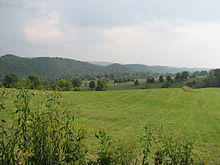
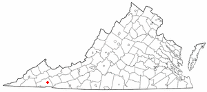
Scott County is a county located in the southwestern part of the U.S. state of Virginia. As of the 2020 census, the population was 21,576. Its county seat is Gate City. Scott County was formed by an act of the General Assembly on November 24, 1814, from parts of Washington, Lee, and Russell Counties and was named for Virginia born General Winfield Scott. Scott County is part of the Kingsport–Bristol–Bristol, TN-VA Metropolitan Statistical Area, which is a component of the Johnson City–Kingsport–Bristol, TN-VA Combined Statistical Area, commonly known as the "Tri-Cities" region. The County Administrator is Freda Russell Starnes.

<span class="mw-page-title-main">Russell County, Virginia</span> County in Virginia, United States

Russell County is a county located in the Commonwealth of Virginia. As of the 2020 census, the population was 25,781. Its county seat is Lebanon.

<span class="mw-page-title-main">Pulaski County, Virginia</span> County in Virginia, United States

Pulaski County is a county located in the southwestern part of the U.S. state of Virginia. As of the 2020 census, the population was 33,800. Its county seat is Pulaski. Pulaski County is part of the Blacksburg–Christiansburg, VA Metropolitan Statistical Area.

<span class="mw-page-title-main">Lancaster County, Virginia</span> County in Virginia, United States

Lancaster County is a county located on the Northern Neck in the Commonwealth of Virginia. As of the 2020 census, the population sits at 10,919. Its county seat is Lancaster.

<span class="mw-page-title-main">Halifax County, Virginia</span> County in Virginia, United States

Halifax County is a county located in the Commonwealth of Virginia. As of the 2020 census, the population was 34,022. Its county seat is Halifax.

<span class="mw-page-title-main">Dickenson County, Virginia</span> County in Virginia, United States

Dickenson County is a county located in the Commonwealth of Virginia. As of the 2020 census, the population was 14,124. Its county seat is Clintwood.

<span class="mw-page-title-main">Craig County, Virginia</span> County in Virginia, United States

Craig County is a county located in the Commonwealth of Virginia. As of the 2020 census, the population was 4,892. Its county seat is New Castle.

<span class="mw-page-title-main">Bland County, Virginia</span> County in Virginia, United States

Bland County is a county located in the southwestern portion of the Commonwealth of Virginia. The county seat is the unincorporated area of Bland. At the 2020 census, the population was 6,270.

<span class="mw-page-title-main">Appomattox County, Virginia</span> County in Virginia, United States

Appomattox County is a United States county located in the Piedmont region and near the center of the Commonwealth of Virginia. The county is part of the Lynchburg, VA Metropolitan Statistical Area, and its county seat is the town of Appomattox.

<span class="mw-page-title-main">Unicoi County, Tennessee</span> County in Tennessee, United States

Unicoi County is a county located in the U.S. state of Tennessee. As of the 2020 census, the population was 17,928. Its county seat is Erwin. Unicoi is a Cherokee word meaning "white," "hazy," "fog-like," or "fog draped," and refers to the mist often seen in the foothills and mountains of this far northeast county. Unicoi County is part of the Johnson City Metropolitan Statistical Area, which is a component of the Johnson City–Kingsport–Bristol, TN-VA Combined Statistical Area, commonly known as the "Tri-Cities" region.

<span class="mw-page-title-main">Abingdon, Virginia</span> Town in Virginia, United States

Abingdon is a town in Washington County, Virginia, United States, 133 miles (214 km) southwest of Roanoke. The population was 8,376 at the 2020 census. It is the county seat of Washington County. The town encompasses several historically significant sites and features a fine arts and crafts scene centered on the galleries and museums along Main Street.

<span class="mw-page-title-main">Emory-Meadowview, Virginia</span> Former CDP in Virginia, United States

Emory-Meadowview was a census-designated place (CDP) in Washington County, Virginia, United States. The population was 2,266 at the 2000 census. It is part of the Kingsport–Bristol (TN)–Bristol (VA) Metropolitan Statistical Area, which is a component of the Johnson City–Kingsport–Bristol, TN-VA Combined Statistical Area – commonly known as the "Tri-Cities" region. As of the 2010 census it was split into Emory and Meadow View CDPs.

<span class="mw-page-title-main">Glade Spring, Virginia</span> Town in Virginia, United States

Glade Spring is a town in Washington County, Virginia, United States. The population was 1,456 at the 2010 census. It is part of the Kingsport–Bristol (TN)–Bristol (VA) Metropolitan Statistical Area, which is a component of the Johnson City–Kingsport–Bristol, TN-VA Combined Statistical Area – commonly known as the "Tri-Cities" region. I-81 runs through Glade Spring. It is located at exit 29.

<span class="mw-page-title-main">Saltville, Virginia</span> Town in Virginia, United States

Saltville is a town in Smyth and Washington counties in the U.S. state of Virginia. The population was 2,077 at the 2010 census. It is part of the Kingsport–Bristol (TN)–Bristol (VA) Metropolitan Statistical Area, which is a component of the Johnson City–Kingsport–Bristol, TN-VA Combined Statistical Area – commonly known as the "Tri-Cities" region.

<span class="mw-page-title-main">Carroll County, Virginia</span> County in Virginia, United States

Carroll County is a United States county located in the southwestern part of the Commonwealth of Virginia. Roughly one fifth of the county lies in the Virginia Piedmont region, while the rest is part of the Appalachian Mountains. The county seat and largest town is Hillsville.

References

  1. "Washington County, Virginia". United States Census Bureau . Retrieved January 30, 2022.
  2. "Find a County". National Association of Counties. Retrieved June 7, 2011.
  3. "US Gazetteer files: 2010, 2000, and 1990". United States Census Bureau. February 12, 2011. Retrieved April 23, 2011.
  4. "Census of Population and Housing from 1790-2000". US Census Bureau . Retrieved January 24, 2022.
  5. "Historical Census Browser". University of Virginia Library. Retrieved January 5, 2014.
  6. "Population of Counties by Decennial Census: 1900 to 1990". United States Census Bureau. Retrieved January 5, 2014.
  7. 1 2 "P2 HISPANIC OR LATINO, AND NOT HISPANIC OR LATINO BY RACE - 2010: DEC Redistricting Data (PL 94-171) - Washington County, Virginia". United States Census Bureau .
  8. 1 2 "P2 HISPANIC OR LATINO, AND NOT HISPANIC OR LATINO BY RACE - 2020: DEC Redistricting Data (PL 94-171) - Washington County, Virginia". United States Census Bureau .
  9. "U.S. Census website". United States Census Bureau . Retrieved May 14, 2011.
  10. Leip, David. "Dave Leip's Atlas of U.S. Presidential Elections". uselectionatlas.org. Retrieved December 9, 2020.

36°43′N81°58′W / 36.72°N 81.96°W / 36.72; -81.96