A ZIP Code is a postal code used by the United States Postal Service (USPS) in a system it introduced in 1963. The term ZIP is an acronym for Zone Improvement Plan; it was chosen to suggest that the mail travels more efficiently and quickly when senders use the code in the postal address. The basic format consists of five digits. An extended ZIP+4 code was introduced in 1983 which includes the five digits of the ZIP Code, followed by a hyphen and four additional digits that reference a more specific location.

Arcola is an unincorporated community in Upper Providence Township, Montgomery County, Pennsylvania, United States. Arcola is located on Perkiomen Creek 6.5 miles (10.5 km) west-northwest of Norristown. Arcola has a post office with ZIP code 19420, which opened on June 4, 1889.

Yolyn is an unincorporated community in Logan County, West Virginia, United States. Yolyn is 7 miles (11 km) east-southeast of Logan. Yolyn had a post office, which closed on March 3, 2007.

Church View is an unincorporated community in Middlesex County, Virginia, United States. Church View is located on U.S. Route 17 6.3 miles (10.1 km) west-northwest of Urbanna. Church View has a post office with ZIP code 23032, which opened on May 20, 1852.
Blackwater is an unincorporated community in Lee County, Virginia, United States. Blackwater is located along Virginia State Route 70 5.4 miles (8.7 km) southeast of Jonesville. Blackwater has a post office with ZIP code 24221.
East Stone Gap is an unincorporated community in Wise County, Virginia, United States. East Stone Gap is an eastern suburb of Big Stone Gap; U.S. Route 23 separates the two settlements. East Stone Gap has a post office with ZIP code 24246.
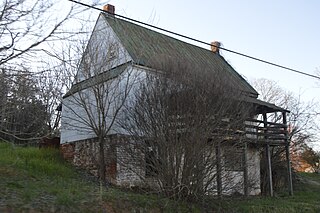
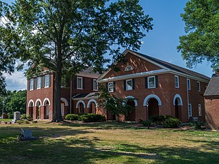
Clifford is an unincorporated community in Amherst County, Virginia, United States. Clifford is located on Virginia State Route 151 4.3 miles (6.9 km) north-northeast of Amherst. Clifford has a post office with ZIP code 24533, which opened on March 23, 1883. Five sites in the vicinity of Clifford are listed on the National Register of Historic Places: Brick House, Clifford-New Glasgow Historic District, Geddes, Mountain View Farm, and Winton.

Big Creek is an unincorporated community in Clay County, Kentucky, United States. Big Creek is located on U.S. Route 421, 10.7 miles (17.2 km) east of Manchester. Big Creek has a post office with ZIP code 40914.

Laughlintown is an unincorporated community in Ligonier Township, Westmoreland County, Pennsylvania, United States. Laughlintown is located on U.S. Route 30 3 miles (4.8 km) southeast of Ligonier. Laughlintown has a post office with ZIP code 15655, which opened on May 16, 1825.

Abernant is an unincorporated community in Tuscaloosa County, Alabama, United States. Abernant is located along Alabama State Route 216, 3.6 miles (5.8 km) west of Lake View. Abernant has a post office with ZIP code 35440.
Alton is an unincorporated community in Jefferson County, Alabama, United States. Alton is located along Interstate 459, 10 miles (16 km) east-northeast of downtown Birmingham. Alton has a post office with ZIP code 35015.
Sayre is an unincorporated community in Jefferson County, Alabama, United States. Sayre is 16.5 miles (26.6 km) northwest of downtown Birmingham. Sayre had a post office from October 4, 1904, to November 5, 2011; it still has its own ZIP code, 35139.
Steele is an unincorporated community in Pike County, Kentucky. Steele is 18.2 miles (29.3 km) east-southeast of Pikeville. Steele has a post office with ZIP code 41566, which opened on February 5, 1906.

Little York is an unincorporated community located along the border of Alexandria and Holland townships in Hunterdon County, New Jersey, United States. Little York is located on County Route 614 3.1 miles (5.0 km) north-northeast of Milford. Little York has a post office with ZIP code 08834.

Grenloch is an unincorporated community located within Washington Township, Gloucester County, New Jersey, United States. Grenloch is located along New Jersey Route 168 10.25 miles (16.50 km) south-southeast of Camden. Grenloch has a post office with ZIP code 08032.

South Seaville is an unincorporated community located within Dennis Township in Cape May County, New Jersey, United States. South Seaville is 4 miles (6.4 km) northwest of Sea Isle City. South Seaville has a post office with ZIP code 08246.

Pray is a census-designated place and unincorporated community in Park County, Montana, in the Paradise Valley. The town was founded in 1907 by Valentine Eggar, an entrepreneur. He named it after Congressman Charles Nelson Pray. Its population was 681 as of the 2010 census. Pray has a post office with ZIP code 59065, which opened on December 8, 1909.

Coyote is a census-designated place in Rio Arriba County, New Mexico, United States. Its population was 128 as of the 2010 census. Coyote has a post office with ZIP code 87012. New Mexico State Road 96 passes through the community.
Los Ojos is a census-designated place in Rio Arriba County, New Mexico, United States. Its population was 125 as of the 2010 census. Los Ojos has a post office with ZIP code 87551, which opened on February 7, 1877. The community is near U.S. Route 64 and U.S. Route 84.
Morning View is an unincorporated community in Kenton County, Kentucky, United States. The community is located along the Licking River at the intersection of Kentucky Route 14 and Kentucky Route 177, 9 miles (14 km) south-southeast of Independence. Morning View has a post office with ZIP code 41063.