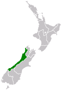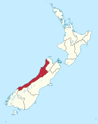
The West Coast is a region of New Zealand on the west coast of the South Island that is administered by the West Coast Regional Council, and is known co-officially as Te Tai Poutini. It comprises the territorial authorities of Buller District, Grey District and Westland District. The principal towns are Westport, Greymouth and Hokitika. The region, one of the more remote areas of the country, is also the most sparsely populated. With a population of just 32,000 people, the West Coast is the least populous region in New Zealand, and it is the only region where the population is declining.

A septic tank is an underground chamber made of concrete, fiberglass, or plastic through which domestic wastewater (sewage) flows for basic sewage treatment. Settling and anaerobic digestion processes reduce solids and organics, but the treatment efficiency is only moderate. Septic tank systems are a type of simple onsite sewage facility. They can be used in areas that are not connected to a sewerage system, such as rural areas. The treated liquid effluent is commonly disposed in a septic drain field, which provides further treatment. Nonetheless, groundwater pollution may occur and can be a problem.

Wastewater treatment is a process which removes and eliminates contaminants from wastewater and converts this into an effluent that can be returned to the water cycle. Once returned to the water cycle, the effluent creates an acceptable impact on the environment or is reused for various purposes. The treatment process takes place in a wastewater treatment plant. There are several kinds of wastewater which are treated at the appropriate type of wastewater treatment plant. For domestic wastewater, the treatment plant is called a Sewage Treatment. For industrial wastewater, treatment either takes place in a separate Industrial wastewater treatment, or in a sewage treatment plant. Further types of wastewater treatment plants include Agricultural wastewater treatment and leachate treatment plants.

The Clean Water Act (CWA) is the primary federal law in the United States governing water pollution. Its objective is to restore and maintain the chemical, physical, and biological integrity of the nation's waters; recognizing the responsibilities of the states in addressing pollution and providing assistance to states to do so, including funding for publicly owned treatment works for the improvement of wastewater treatment; and maintaining the integrity of wetlands.
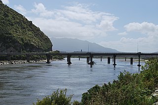
The Grey River / Māwheranui is located in the northwest of the South Island of New Zealand. It rises 12 kilometres southwest of the Lewis Pass in Lake Christabel, one of numerous small lakes on the western side of the Southern Alps, and runs westward for 120 kilometres before draining into the Tasman Sea at Greymouth. Thomas Brunner, who explored the area in the late 1840s, named the river in honour of Sir George Grey, who first served as Governor of New Zealand from 1845 to 1854. The Ngāi Tahu Claims Settlement Act 1998 changed the official name of the river to Grey River / Māwheranui in 1998. The Māori name for the river system and surrounding area is Māwhera, with Māwheranui being distinguished from the northern branch Little Grey River / Māwheraiti.
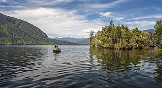
Lake Brunner is the largest lake in the West Coast Region of New Zealand, located 31 km (19 mi) southeast of Greymouth. The main settlement, Moana, is on its northern shore. It is an important settlement and waystation for local Māori. The first Europeans in the area were loggers, and sawmills were an important early industry. Being several kilometres inland from the coast road, it is less frequently visited by tourists than many of the West Coast's scenic highlights, but it is becoming increasingly popular, in part due to its reputation for fishing.

Agricultural wastewater treatment is a farm management agenda for controlling pollution from confined animal operations and from surface runoff that may be contaminated by chemicals in fertilizer, pesticides, animal slurry, crop residues or irrigation water. Agricultural wastewater treatment is required for continuous confined animal operations like milk and egg production. It may be performed in plants using mechanized treatment units similar to those used for industrial wastewater. Where land is available for ponds, settling basins and facultative lagoons may have lower operational costs for seasonal use conditions from breeding or harvest cycles. Animal slurries are usually treated by containment in anaerobic lagoons before disposal by spray or trickle application to grassland. Constructed wetlands are sometimes used to facilitate treatment of animal wastes.

The River Perry is a river in Shropshire, England. It rises near Oswestry and flows south to meet the River Severn above Shrewsbury. Along its 24 miles (39 km) length, its level drops by some 320 feet (95 m). The channel has been heavily engineered, both to enable water mills to be powered by it, and to improve the drainage of the surrounding land. There were at least seven corn mills in the 1880s, and the last one remained operational until 1966. The middle section of the river crosses Baggy Moor, where major improvements were made in 1777 to drain the moor. The scheme was one of the largest to enclose and improve land in North Shropshire, and the quality of the reclaimed land justified the high cost. A section of the river bed was lowered in the 1980s, to continue the process.
The Western Treatment Plant is a 110 km2 (42 sq mi) sewage treatment plant in Cocoroc, Victoria, Australia, 30 km (19 mi) west of Melbourne's central business district, on the coast of Port Phillip Bay. It was completed in 1897 by the Melbourne and Metropolitan Board of Works (MMBW), and is currently operated by Melbourne Water. The plant's land is bordered by the Werribee River to the east, the Princes Freeway to the north, and Avalon Airport to the west. It forms part of the Port Phillip Bay and Bellarine Peninsula Ramsar Site as a wetland of international importance. The Western Treatment Plant treats around fifty percent of Melbourne's sewage — about 485 megalitres or 393 acre-feet per day — and generates almost 40,000 megalitres or 32,000 acre-feet of recycled water a year.
The Dairying and Clean Streams Accord is an agreement signed in 2003 in New Zealand between Fonterra, Ministry for the Environment, Ministry of Agriculture and Forestry and regional councils. The Accord was prompted by the high-profile "dirty dairying" campaign by Fish and Game New Zealand which highlighted water pollution of lakes, rivers and streams due to the intensification of dairy farming in parts of New Zealand.
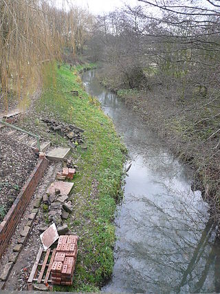
The River Doe Lea is a river which flows near Glapwell and Doe Lea in Derbyshire, England. The river eventually joins the River Rother near Renishaw. The river contained 1,000 times the safe level of dioxins in 1991, according to a statement made by Dennis Skinner, (MP) in the House of Commons in 1992. The river flows through the site of the former Coalite plant near Bolsover, where coke, tar and industrial chemicals were manufactured until the plant closed in 2004.
In New Zealand "dirty dairying" refers to damage to the ecological health of New Zealand's freshwater environment by the intensification of dairy farming, and also to the high profile campaign begun in 2002 by the Fish and Game Council to highlight and combat this.

The Waitetuna River is a river of the Waikato Region of New Zealand's North Island. It flows generally northwest from its sources southwest of Whatawhata to reach the southeastern coast of the Raglan Harbour.

Water pollution in New Zealand is an increasing concern for those who use and care for waterways and for New Zealand regulatory bodies. An increase in population is linked to an increase in water pollution, due to a range of causes such as rural land use, industrial use and urban development. Fresh water quality is under pressure from agriculture, hydropower, urban development, pest invasions and climate change. While pollution from point sources has been reduced, diffuse pollution such as nutrients, pathogens and sediments development and from stormwater in towns is not under control. There are more than 800 water quality monitoring sites around New Zealand that are regularly sampled.
A regional water authority, commonly known as a water board, was one of a group of public bodies that came into existence in England and Wales in April 1974, as a result of the Water Act 1973 coming into force. This brought together in ten regional units a diverse range of bodies involved in water treatment and supply, sewage disposal, land drainage, river pollution and fisheries. They lasted until 1989, when the water industry was privatised and the water supply and sewerage and sewage disposal parts became companies and the regulatory arm formed the National Rivers Authority. Regional water authorities were also part of the Scottish water industry when three bodies covering the North, West and East of Scotland were created in 1996, to take over responsibilities for water supply and sewage treatment from the regional councils, but they only lasted until 2002, when they were replaced by the publicly owned Scottish Water.

Water pollution in Canterbury, New Zealand has become a major environmental issue, largely due to pollution from agricultural sources, but also industrial and urban sources.

Water pollution in the United States is a growing problem that became critical in the 19th century with the development of mechanized agriculture, mining, and industry, although laws and regulations introduced in the late 20th century have improved water quality in many water bodies. Extensive industrialization and rapid urban growth exacerbated water pollution as a lack of regulation allowed for discharges of sewage, toxic chemicals, nutrients and other pollutants into surface water.

Mogden Sewage Treatment Works is a sewage treatment plant in the Ivybridge section of Isleworth, West London, formerly known as Mogden. Built in 1931–36 by Middlesex County Council and now operated by Thames Water, it is the third largest sewage works in the United Kingdom. It treats the waste water from about 1.9 million people served by three main sewers serving more than the northwest quarter of Outer London and two further main sewers from the south and south-west. The plant has been extended and is constantly being upgraded with new process, most recently in OfWat Amp6 by the Costain Atkins Joint venture who delivered 6MW of Combined Heat and Power (CHP) generation, New process air blowers for Batteries A & B and six gravity sludge thickening streams. The site covers 55 hectares.
Water quality in Taranaki is a notable environmental issue for many stakeholders with concerns about the potential impact from dairy farming in New Zealand and petrochemical industries.
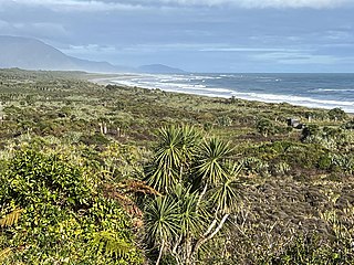
The Barrytown Flats are a 17 km (11 mi) coastal plain north of Greymouth on the West Coast of New Zealand's South Island. A series of postglacial shorelines and dunes backed by a former sea cliff, they was originally covered with wetland and lowland forest, including numerous nīkau palms. The sands were extensively sluiced and dredged for gold from the 1860s, centred on the small settlement of Barrytown. The drier areas of the flats have been converted into pasture, but significant areas of forest remain, including Nikau Scenic Reserve. The flats are bordered by Paparoa National Park and the only breeding site of the Westland petrel. There are significant deposits of ilmenite in the Barrytown sands, and there have been several mining proposals, but the possible environmental consequences have been contentious.