Waterman Mountain

Last updated
Waterman Mountain
Relief map of California.png
Red triangle with thick white border.svg
Waterman Mountain
Location in California
Usa edcp relief location map.png
Red triangle with thick white border.svg
Waterman Mountain
Waterman Mountain (the US)
Highest point
Elevation 8,041 ft (2,451 m)  NAVD 88 [1]
Listing Hundred Peaks Section [2]
Coordinates 34°20′10″N117°56′11″W / 34.3361112°N 117.9364538°W / 34.3361112; -117.9364538 Coordinates: 34°20′10″N117°56′11″W / 34.3361112°N 117.9364538°W / 34.3361112; -117.9364538 [3]
Geography
Location Los Angeles County, California, U.S.
Parent range San Gabriel Mountains
Topo map USGS Waterman Mountain
Climbing
Easiest route Waterman Loop, Trail hike class 1

Waterman Mountain, at 8,041 feet (2,451 m), is a prominent peak in the San Gabriel Mountains of Los Angeles County, California, within the Angeles National Forest and San Gabriel Mountains National Monument.

San Gabriel Mountains mountain range in Los Angeles and San Bernardino Counties, California

The San Gabriel Mountains are a mountain range located in northern Los Angeles County and western San Bernardino County, California, United States. The mountain range is part of the Transverse Ranges and lies between the Los Angeles Basin and the Mojave Desert, with Interstate 5 to the west and Interstate 15 to the east. This range lies in, and is surrounded by, the Angeles National Forest, with the San Andreas Fault as the northern border of the range.

Los Angeles County, California County in California, United States

Los Angeles County, officially the County of Los Angeles, in the Los Angeles metropolitan area of the U.S. state of California, is the most populous county in the United States, with more than 10 million inhabitants as of 2017. As such, it is the largest non–state level government entity in the United States. Its population is larger than that of 41 individual U.S. states. It is the third-largest metropolitan economy in the world, with a Nominal GDP of over $700 billion—larger than the GDPs of Belgium, Norway, and Taiwan. It has 88 incorporated cities and many unincorporated areas and, at 4,083 square miles (10,570 km2), it is larger than the combined areas of Delaware and Rhode Island. The county is home to more than one-quarter of California residents and is one of the most ethnically diverse counties in the U.S. Its county seat, Los Angeles, is also California's most populous city and the nation's second largest city with about 4 million people.

Angeles National Forest

The Angeles National Forest (ANF) of the U.S. Forest Service is located in the San Gabriel Mountains and Sierra Pelona Mountains, primarily within Los Angeles County in southern California. The ANF manages a majority of the San Gabriel Mountains National Monument.

Contents

The summit of Waterman Mountain marks the northern boundary of the San Gabriel Wilderness and it is the highest point in the wilderness. [1] [4]

San Gabriel Wilderness

The San Gabriel Wilderness is a wilderness area created in 1968 of more than 36,118 acres (150 km2) within the Angeles National Forest and San Gabriel Mountains National Monument.

Ecology

During winter and early spring this mountain is packed with snow. Snow may even be found in September lying on Waterman mountain. Spring brings a lot of rain and makes Waterman covered in wildflowers. Summers are hot and dry. The climate here is Highlands/Mediterranean. Partly due to this climate, mixed conifer forests are found on Waterman Mountain, Fauna is greatly influenced because of this climate.

Recreation

Several small ski areas are located on its north side: Mount Waterman, Kratka Ridge, and Buckhorn Ski Club.

Mount Waterman

Mount Waterman is a ski area on Waterman Mountain in the San Gabriel Mountains of the Angeles National Forest in Los Angeles County, California. The area is located on California State Route 2, the Angeles Crest Highway, and reaches a height of 8,030 ft (2,450 m) with an overall vertical drop of 1,030 ft (310 m). Mount Waterman is leased under a special use permit from the United States Forest Service. Skiable terrain is distributed as: 20% beginner, 20% intermediate, and 60% advanced.

Kratka Ridge or Snowcrest is a skiable area on Waterman Mountain in the San Gabriel Mountains of Los Angeles County, California. Located 36 miles northeast of La Cañada and Pasadena along the Angeles Crest Highway, it reaches a height of 7515 feet.

Buckhorn Ski Club

Buckhorn Ski and Snowboard Club is located roughly 40 mi (64 km) north of Los Angeles in the Angeles National Forest. The U.S. Department of Agriculture owns the land and the United States Forest Service administers the area. It is a cooperative club with nominal dues but all members are expected to contribute time to maintenance.

The Buckhorn and Cooper Campgrounds are below the peak on the Angeles Crest Highway.

Angeles Crest Highway highway in California

The Angeles Crest Highway is a two-lane highway over the San Gabriel Mountains, in Los Angeles County, California. Its route is to/through the San Gabriel Mountains National Monument and the Angeles National Forest. With the exception of a 1,000 feet (300 m)-long section in La Cañada Flintridge, the entire route is part of California State Route 2.

History

Robert B. Waterman was a pioneer mountain man and a ranger in the San Gabriel Forest Reserve. He, with his wife Liz and their friend Perry Switzer, completed a three-week journey from La Cañada to the Antelope Valley and back in May 1889. With this accomplishment, Liz became the first non-indigenous woman known to have crossed the San Gabriel Mountains. It is said that she placed a cairn on this summit and so it was named Lady Waterman's Peak. However, with prevailing attitudes toward the "weaker sex" the name was not accepted and it became known as simply Waterman Mountain. [5]

La Cañada Flintridge, California City in California, United States

La Cañada Flintridge is a city in Los Angeles County, California, with a population of 20,246 in 2010. It is located in the Crescenta Valley and far western end of the San Gabriel Valley, to the northwest of Pasadena. It is the home of NASA's Jet Propulsion Laboratory.

Antelope Valley

Antelope Valley is located in northern Los Angeles County, California, and the southeast portion of Kern County, California, and constitutes the western tip of the Mojave Desert. It is situated between the Tehachapi and the San Gabriel Mountains. The valley was named for the pronghorns that roamed there until they were all but eliminated in the 1880s, mostly by hunting, or resettled in other areas. The principal cities in the Antelope Valley are Palmdale and Lancaster.

The area was severely impacted by the Station fire in 2009. [6]

Related Research Articles

Mount Charleston mountain

Mount Charleston, including Charleston Peak at 11,916 feet (3,632 m), is the highest mountain in both the Spring Mountains and Clark County, in Nevada, United States. It is the eighth-highest mountain in the state. Well separated from higher peaks by large, low basins, Charleston Peak is the most topographically prominent peak in Nevada, and the eighth-most-prominent peak in the contiguous United States. It is one of eight ultra-prominent peaks in Nevada. It is located about 35 miles (56 km) northwest of Las Vegas within the Mount Charleston Wilderness, which is within the Spring Mountains National Recreation Area of the Humboldt–Toiyabe National Forest.

Mount San Antonio mountain

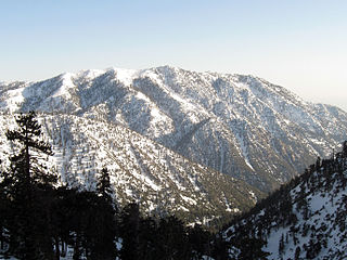
Mount San Antonio, colloquially referred to as Mount Baldy, is the highest peak of the San Gabriel Mountains, and the highest point in Los Angeles County, California. The peak is within the San Gabriel Mountains National Monument and Angeles National Forest. It is the tallest mountain in the Los Angeles metropolitan area. Mount San Antonio's sometimes snow-capped peaks are visible on clear days and dominate the view of the Los Angeles Basin skyline. The peak is pyramid shaped, with a steep south face and a shallower north face. The summit is accessible via a number of connecting ridges along hiking trails from the north, east, south and southwest.

Mount Tom (California) mountain in eastern California

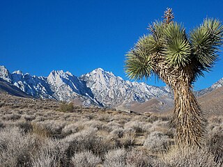
Mount Tom is a large and prominent peak near the city of Bishop in Inyo County of eastern California. It is in the Sierra Nevada and east of the Sierra Crest. The mountain is also in the John Muir Wilderness.

Cucamonga Peak mountain in United States of America

Cucamonga Peak, at 8,862 feet (2,701 m) is one of the highest peaks of the San Gabriel Mountains, and is located in San Bernardino County, California. It is within the Cucamonga Wilderness of the San Bernardino National Forest.

Owens Peak mountain in United States of America

Owens Peak is the highest point in the southern Sierra Nevada Mountains at more than 8,400 feet. The peak stands near the center of the Owens Peak Wilderness which was designated by United States Congress in 1994, and it now has a total of 74,060 acres (299.7 km2). The eastern watershed of Owens Peak is composed of three main canyons: Grapevine Canyon, Short Canyon, and Indian Wells Canyon. The Sierra Nevada meets the Great Basin and the Mojave Desert here, creating an unusual ecosystem.

Iron Mountain (Los Angeles County) peak in the San Gabriel Mountains, Los Angeles County, California

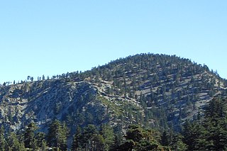
Iron Mountain is a mountain in the San Gabriel Mountains of Los Angeles County, California. It is within the San Gabriel Mountains National Monument, in the section managed by the Angeles National Forest.

Mount Burnham peak in the San Gabriel Mountains

Mount Burnham is one of the highest peaks in the San Gabriel Mountains. It is in the Sheep Mountain Wilderness. It is named for Frederick Russell Burnham the famous American military scout who taught Scoutcraft to Robert Baden-Powell and became one of the inspirations for the founding of the Boy Scouts. Mount Burnham was officially recognized by the USGS at a dedication ceremony in 1951. It was original known as "North Baldy Mountain". The peak is within Los Angeles County, about 16 miles (26 km) north of Glendora, and 66 miles (106 km) from Los Angeles. In 1956, Mount Burnham was added to the list of Signature Summits by the Hundred Peaks Section of the Sierra Club.

Mount Tallac mountain peak southwest of Lake Tahoe, California, United States of America

Mount Tallac is a mountain peak southwest of Lake Tahoe, in El Dorado County, California. The peak lies within the Desolation Wilderness in the Eldorado National Forest. It is quite visible from State Routes 89 and 28, and U.S. Route 50. A "cross of snow" is clearly visible on the mountain's face during the winter, spring, and early summer months.

Mount Harwood mountain in California, United States

Mount Harwood is the first summit east of Mount San Antonio. The United States Geological Survey recognized the name to honor California educator and conservationist Aurelia Squire Harwood in 1965. Prior to this, the peak now known as Thunder Mountain was also referred to as Mount Harwood. Mount Harwood is located on the East side of the San Gabriel Mountains in the Angeles National Forest near the San Bernardino-Los Angeles county border. In this area of the San Gabriel Mountains the peaks are the highest. Because of the elevation Mount Harwood turns out to be ranked the 4th highest peak in the San Gabriel mountains after Dawson Peak, Mount San Antonio or "Old Baldy" being the highest at 10,064 feet. The only way for hikers or tourists to access Mount Harwood is to take Mt. Baldy Road off I-210. A National Forest Adventure pass/ National Park access pass must be displayed on a vehicle to access Mount Harwood.

Telegraph Peak (California) mountain in California, United States of America

Telegraph Peak, is a peak of the San Gabriel Mountains, in the San Gabriel Mountains National Monument and San Bernardino County, California.

Anderson Peak (San Bernardino Mountains) mountain in California, United States of America

Anderson Peak is a mountain on the Mount San Gorgonio crestline in Southern California's San Gorgonio Wilderness, which is part of the San Bernardino National Forest. It is 3.2 miles (5.1 km) from Jepson Peak. Although not above the tree line, snow tends to cover the crest from early winter until late spring.

Big Pine Mountain is a mountain located in the San Rafael Mountains of the California Transverse Ranges. High enough to receive snowfall during the winter, The summit, at 6820+ feet (2,073+ m), is the highest point in the San Rafael Mountains, the Dick Smith Wilderness, and Santa Barbara County.

Mount Rose (Nevada) mountain in United States of America

Mount Rose is the highest mountain in Washoe County, within the Carson Range of Nevada, United States. It ranks thirty-seventh among the most topographically prominent peaks in the state. It is also both the highest and most topographically prominent peak of the greater Sierra Nevada range within the state of Nevada, and the third most topographically prominent peak in the Sierra Nevada overall. It is located in the Mount Rose Wilderness of the Humboldt-Toiyabe National Forest. An extinct volcano, the mountain is in between Lake Tahoe and Reno. State Route 431 traverses Mount Rose Summit southeast of Mount Rose. Due to the high elevation, most of the precipitation that falls on the mountain is snow. The view from Mount Rose, facing east is the Truckee Meadows area is the second largest population center in Nevada.

Florence Peak (California) mountain in United States of America

Florence Peak is a mountain located on the Great Western Divide, a sub-range of the southern Sierra Nevada of California. It is located about 6 miles (9.7 km) southeast of the community of Silver City and 4.5 miles (7.2 km) from the roads end at Mineral King. It marks the southern boundary of Sequoia National Park. On the summit the Sequoia-Kings Canyon Wilderness, the John Krebs Wilderness and Golden Trout Wilderness meet.

Ontario Peak mountain in United States of America

Ontario Peak, at 8,696 ft, is a high peak in the San Gabriel Mountains of California. Like its neighbor Cucamonga Peak, it is in the San Bernardino National Forest, and in the Cucamonga Wilderness. The peak is named for the nearby city of Ontario about 12 miles (19 km) due south, and first appeared in the General Land Office Forest Atlas in 1908.

Strawberry Peak mountain in United States of America

Strawberry Peak is a prominent peak in the San Gabriel Mountains of Los Angeles County, California. It is located about 10 miles (16 km) north of Pasadena, and 28 miles (45 km) from Los Angeles, along the Angeles Crest Highway. Strawberry Peak is the tallest of the front range peaks, being three feet higher than nearby San Gabriel Peak. Both can be widely seen from greater Los Angeles and the San Gabriel Valley, and are popular with hikers. Other prominent nearby peaks include Josephine Peak and Mount Wilson. Strawberry Peak was named by mountaineers over a century ago, who felt the peak resembled an enormous upside-down strawberry.

Throop Peak mountain in United States of America

Throop Peak is a 9,142 feet (2,786 m) peak of the San Gabriel Mountains, in the San Gabriel Mountains National Monument and Angeles National Forest, in Los Angeles County, California.

Mount Lukens mountain in United States of America

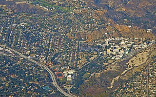
Mount Lukens is a mountain peak of the San Gabriel Mountains, in Los Angeles County, Southern California.

Timber Mountain (San Bernardino County, California)

Timber Mountain is a peak of the San Gabriel Mountains, located in the Cucamonga Wilderness, Angeles National Forest, San Bernardino County, California.

References

  1. 1 2 "Waterman Mountain, California". Peakbagger.com. Retrieved 2009-03-06.
  2. "Waterman Mountain". Hundred Peaks Section List. Angeles Chapter, Sierra Club . Retrieved 2014-03-08.
  3. "Waterman Mountain". Geographic Names Information System . United States Geological Survey . Retrieved 2009-03-06.
  4. "San Gabriel Wilderness". Angeles National Forest, U.S. Forest Service. Retrieved 2014-03-08.
  5. "Summit Signature: 14A Waterman Mountain". Hundred Peaks Section, Angeles Chapter of the Sierra Club. Retrieved 2014-03-08.
  6. "After the Station Fire: Three Points - Mt. Waterman Loop". Photography on the Run. Retrieved 2014-03-08.