Waun Garnedd-y-filiast | |
---|---|
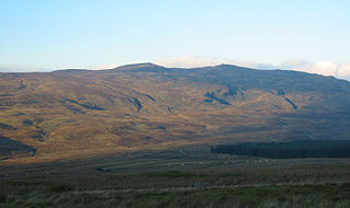
Waun Garnedd-y-filiast (left) and Carnedd y Filiast (right) from the summit of Carnedd Llechwedd-llyfn | |
Highest point | |
Elevation | 651 m (2,136 ft) |
Prominence | 15 m (49 ft) |
Parent peak | Carnedd y Filiast |
Listing | Nuttall |
Geography | |
Location | Gwynedd, Wales |
Parent range | Snowdonia |
Topo map | OS Landranger 115 |
Waun Garnedd-y-filiast is a top of Carnedd y Filiast on the border of the Snowdonia National park near Cerrigydrudion in North Wales. It is part of the Arenig mountain range. It is also a peak in an area of moorland known as the Migneint.
Carnedd y Filiast is a mountain near Cerrigydrudion on the border of the Snowdonia National Park, North Wales and is 669 metres (2,195 ft) high.
Snowdonia is a mountainous region in northwestern Wales and a national park of 823 square miles (2,130 km2) in area. It was the first to be designated of the three national parks in Wales, in 1951. It contains the highest peaks in the United Kingdom outside of Scotland.
Cerrigydrudion, sometimes spelt Cerrig-y-drudion, is a village and community in Conwy, Wales. Until 1974 it was part of the historic county Denbighshire, when it became part of the newly formed county of Clwyd. When the county of Clwyd was abolished in 1996, the village was transferred to the new Conwy County Borough. The village formerly lay on the A5, but a short by-pass now takes the road along the south-western edge of the village. Prior to the by-pass being built, Cerrigydrudion was the highest village on the A5 between London and Holyhead. The community includes the hamlets of Cefn Brith, Glasfryn and Pentre-Llyn-Cymmer with the village having a population of around 289.
The summit is marked by a few stones in an area of peat hags on a small plateau of bog. Foel Goch (Arenigs), Carnedd Llechwedd-llyfn and Mwdwl-eithin can be seen.
Foel Goch is a mountain in north-east Wales, and forms part of the Arenig mountain range. It is the only member of the Arenig group that lies outside of the Snowdonia National Park.
Carnedd Llechwedd-llyfn is a subsidiary summit of Carnedd y Filiast on the border of Snowdonia National Park in Llandderfel, in Gwynedd. The northern slopes of the peak lie in Ysbyty Ifan, in Conwy. It is part of the Arenig mountain range, and rises from the shore of Llyn Celyn.
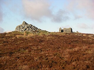
Mwdwl-eithin is the highest point on the Denbigh Moors of North Wales. This gently rising mountain lies about 10 miles (16 km) east of Betws-y-Coed. On its summit is a trig point and a ruined building which still provides shelter against a storm. A few metres away is a large raised stone cairn.
The top was not included in the Nuttall's original list. However, in 1999 it was surveyed to have the following re-ascent 15.1295 m (49 ft 7.5in). Controversy arose due to it not being quite 50 ft. Some walkers choose only to include it in a Metric list along with 600–608 m sub Hewitt summits. However, most walkers regard it as a full Nuttall by now since it rounds up to 50 ft. [1]
Carnedd Llewelyn, usually spelt Carnedd Llywelyn in Welsh, is a mountain massif in the Carneddau range in Snowdonia, north-west Wales. It is the highest point of the Carneddau and the second highest peak by relative height in Wales, 49th in the British Isles and lies on the border between Gwynedd and Conwy.
Tal y Fan is an outlying peak of the Carneddau mountains in North Wales. It is one of the four Marilyns that make up the Carneddau, the others being Carnedd Llywelyn, Pen Llithrig y Wrach and Creigiau Gleision.
Carnedd y Ddelw is a summit in the Carneddau mountains in north Wales, north-east of Foel-fras. It is the Nuttall top of Drum (Wales). Its eastern slopes are drained by the Afon Tafolog, a tributary of Afon Roe that flows through the village of Rowen before joining the River Conwy. It is also the final top on Carnedd Llewelyn's long northern spur. To the north-west is Tal y Fan, the most northerly 2000 foot tall mountain in the Carneddau and Wales. The summit has two large shelter cairns, hollowed out from a large Bronze Age burial cairn.
Carnedd y Filiast is a mountain in Snowdonia, Wales, forming part of the Glyderau. It, along with its top Y Fronllwyd, forms the most northerly summit in the Glyderau. The average annual temperature on Carnedd y Filiast is estimated to be around 4 Celsius.
Mynydd Perfedd is a mountain in Snowdonia, Wales, forming part of the Glyderau. The summit has a shelter cairn, offering good views of Foel-goch's north-eastern face, and the Carneddau.
Arenig Fach is a mountain in southern Snowdonia, north Wales. It is a peak in the Arenig range and lies to the north of its parent peak Arenig Fawr.
Moel Llyfnant is a mountain in the southern portion of the Snowdonia National Park in Gwynedd, Wales. It is a peak in the Arenig mountain range. It lies to the west of Arenig Fawr. It has one notable top, the twin peaked Gallt y Daren, being at the end of its west ridge.
Gallt y Daren is a peak in the southern half of the Snowdonia National Park in Gwynedd, North Wales, and forms part of the Arenig mountain range. It is a top of Moel Llyfnant, and is twin peaked. It lies to the west of Moel Llyfnant.
Foel y Geifr is a subsidiary summit of Esgeiriau Gwynion, and included in a group of hills known as the Hirnantau. These hills rise from the south east shores of Llyn Tegid. Confusion arises when trying to establish to which mountain range these belong to. Since, Foel y Geifr forms part of the Hirnant horseshoe, many consider it to be a Berwyn peak. However, geographically it belong to the Aran Fawddwy group, its parent peak being Esgeiriau Gwynion. It is the eastern outpost of the Arans.
Foel Goch is a subsidiary summit of Esgeiriau Gwynion, and is included in a group of hills known as the Hirnantau. These hills rise from the south east shores of Llyn Tegid.
Trum y Gwragedd is a top of Foel y Geifr in the Hirnantau. These hills rise from the south east shores of Llyn Tegid.
Y Fronllwyd, also known as Carnedd y Filiast North Top, is a top of Carnedd y Filiast in Snowdonia, Wales forming part of the Glyderau. It is the northern end of the Glyder mountain range. The summit has good views of Bethesda, the Penrhyn Quarry, the Carneddau, Elidir Fawr and the Menai Strait. The summit was included on the original Nuttall's list, subsequently deleted and then re-included after detailed re-surveying.
Arenig Fawr South Top is the twin top of Arenig Fawr in southern Snowdonia, North Wales. It is the second highest member of the Arenig range, being 18 m less than its twin. From here the south ridge continues into an area of rocky knolls and small tarns, where Arenig Fawr South Ridge Top can be found.
Arenig Fawr South Ridge Top is a top of Arenig Fawr in southern Snowdonia, North Wales. It lies in area of rocky knolls and small tarns, found on the broad south ridge of Arenig Fawr.
Foel Boeth is the twin top of Gallt y Daren in the southern half of the Snowdonia National Park in Gwynedd, North Wales, and forms part of the Arenig mountain range. Its parent peak is Moel Llyfnant.
Y Gamallt is a mountain located in the Migneint in Snowdonia, North Wales. It forms part of the Arenig mountain range being separated from the Moelwynion range at the head of Cwm Teigl.
Coordinates: 52°59′N3°41′W / 52.983°N 3.683°W
A geographic coordinate system is a coordinate system that enables every location on Earth to be specified by a set of numbers, letters or symbols. The coordinates are often chosen such that one of the numbers represents a vertical position and two or three of the numbers represent a horizontal position; alternatively, a geographic position may be expressed in a combined three-dimensional Cartesian vector. A common choice of coordinates is latitude, longitude and elevation. To specify a location on a plane requires a map projection.
This Gwynedd location article is a stub. You can help Wikipedia by expanding it. |