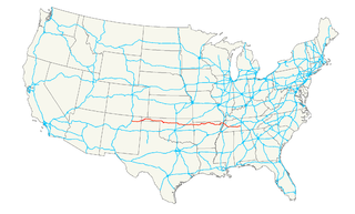
U.S. Route 412 is an east–west United States highway, first commissioned in 1982. Its route number is a "violation" of the usual AASHTO numbering scheme, as it comes nowhere near its implied "parent", US 12. U.S. 412 overlaps expressway-grade Cimarron Turnpike from Tulsa west to Interstate 35 and the Cherokee Turnpike from 5 miles (8.0 km) east of Chouteau, Oklahoma, to 8 miles (13 km) west of the Arkansas state line. A curiosity of this highway is that it runs the entire length of the Oklahoma Panhandle and traverses the Missouri Bootheel.
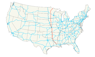
U.S. Route 71 is a major north–south United States highway that extends for over 1500 miles in the central United States. This original 1926 route has remained largely unchanged by encroaching Interstate highways. Currently, the highway's northern terminus is in International Falls, Minnesota at the Canada–US border, at the southern end of the Fort Frances-International Falls International Bridge to Fort Frances, Ontario. U.S. Route 53 also ends here. On the other side of the bridge, Trans-Canada Highway 11 is an east–west route. US 71's southern terminus is between Port Barre and Krotz Springs, Louisiana at an intersection with U.S. Route 190.
U.S. Route 371 is a north–south United States highway in the U.S. states of Arkansas and Louisiana. The highway's northern terminus is in De Queen, Arkansas at an intersection with U.S. Highway 70. It is co-signed for its last 13 miles (21 km) between Lockesburg, Arkansas and DeQueen with U.S. Highway 59 and U.S. Highway 71. Its southern terminus is 5 miles (8.0 km) west of Coushatta, Louisiana at an intersection with Interstate 49.
Interstate 540 (I-540) is a freeway spur route of I-40 in the US state of Arkansas in Fort Smith. The total length is 14.71 miles (23.67 km). At first, I-540 was a short spur connecting Fort Smith and Van Buren to I-40 as one of the original five Arkansas Interstates. The route ran just over 14 miles (23 km) to US 271 near the Oklahoma state line. The growing Northwest Arkansas area and the University of Arkansas needed an Interstate connection to Little Rock, and through traffic north to Kansas City had also outgrown the winding US 71 north from I-40. The route was extended north to Mountainburg in the late 1990s on an all-new alignment with the route being completed to Bella Vista in January 1999. However, the segment north of I-40 became a part of Interstate 49 in 2014.
The Loop is a 21.4-mile-long (34.4 km) beltway around Texarkana, TX and Texarkana, AR, which are twin cities in the U.S. states of Arkansas and Texas. Consisting of a section of Interstate 49 (I-49) in Arkansas, and Loop 151 and a section of I-369 and U.S. Route 59 (US 59) in Texas, it forms a three-quarter loop around the east, south and west sides of the city. The Loop is built to Interstate Highway standards.

Arkansas Highway 367 is a designation for two north–south state highways in Arkansas. A southern route of 15.03 miles (24.19 km) travels north from U.S. Route 167 (US 167) in East End north to US 70 in Little Rock. A northern route of 81.52 miles (131.19 km) begins in Cabot at US 67/AR 5/AR 321 and travels northeast to US 412 in Walnut Ridge.

Highway 72 is a designation for two east–west state highways in Benton County, Arkansas. A western route of 26.32 miles (42.36 km) runs east from Highway 43 at Maysville to U.S. Route 71B (US 71B) in Bentonville. A second route of 12.67 miles (20.39 km) begins at Interstate 49/US Route 71 (I-49/US 71) in Bentonville and runs northeast to US 62 near Avoca. The route is one of the original Arkansas state highways.

Arkansas Highway 265 is a designation for three state highways in Northwest Arkansas. The southern segment of 19.70 miles (31.70 km) runs from Arkansas Highway 170 near Strickler north to I-49/US 71/AR 112 north in south Fayetteville. A more northern segment of 12.07 miles (19.42 km) runs north through east Fayetteville from Arkansas Highway 16 to Arkansas Highway 264 in Springdale. Further north, a third segment of 3.33 miles (5.36 km) runs from Arkansas Highway 94 in Pea Ridge north to the Missouri state line.
Highway 170 is a designation for two state highways in Washington County, Arkansas. The main segment of 17.31 miles (27.86 km) runs from Devil's Den State Park to West Fork. A shorter segment of 5.44 miles (8.75 km) runs from US Route 62 through Appleby before reconnecting with US 62.

Crowley's Ridge Parkway is a 212.0-mile-long (341.2 km) National Scenic Byway in northeast Arkansas and the Missouri Bootheel along Crowley's Ridge in the United States. Motorists can access the parkway from US Route 49 (US 49) at its southern terminus near the Helena Bridge over the Mississippi River outside Helena-West Helena, Arkansas, or from Missouri Route 25 (Route 25) near Kennett, Missouri. The parkway runs along Crowley's Ridge, a unique geological formation, and also parts of the St. Francis National Forest, the Mississippi River and the Mississippi Alluvial Plain. Along the route are many National Register of Historic Places properties, Civil War battlefields, parks, and other archeological and culturally significant points.
Highway 351 is a designation for two state highways in Northeast Arkansas. One route 0.92 miles (1.48 km) in Jonesboro begins at the Interstate 555/US Highway 63 (I-555/US 63) frontage road and runs north to Highway 18 as Industrial Drive. A second route of 13.87 miles (22.32 km) begins at Airport Road and runs north to Highway 358. Between Jonesboro and the northern terminus, the route is designated as part of the Crowley's Ridge Parkway, a National Scenic Byway, and two Civil War trails under the Arkansas Heritage Trails System. Both routes are maintained by the Arkansas State Highway and Transportation Department (AHTD).
Arkansas Highway 226 is a designation for two state highways in northeast Arkansas. The main segment of 25.28 miles (40.68 km) runs east from an intersection of U.S. Route 67/Arkansas Highway 367 to I-555/US 63/AR 18 in Jonesboro. A short route of 2.38 miles (3.83 km) runs in rural Jackson County west of Tuckerman.

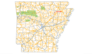
Arkansas Highway 151 is a designation for two north–south state highways in Mississippi County, Arkansas. An eastern route of 5.75 miles (9.25 km) runs from Highway 148 north to Highway 18. A second route of 6.65 miles (10.70 km) begins at Highway 18 in Blytheville and runs north to Missouri supplemental route TT (SSR-TT) at the Missouri state line. A third route was dedicated in May 2013 and begins at State Line Avenue in Texarkana and continues east to Interstate 49/U.S. Route 71.

Highway 38 is a designation for three state highways in Arkansas. One route of 49.58 miles (79.79 km) runs east from Highway 367 at Cabot to US Route 49 (US 49) near Hunter. A second route of 21.43 miles (34.49 km) begins at Interstate 40/US 63 (I-40/US 63) and runs east to Highway 147 near Horseshoe Lake. A third route of 0.10 miles (0.16 km) runs in West Memphis as Martin Luther King Jr. Drive from US 70 north to I-55/US 61/US 64/US 79. All routes are maintained by the Arkansas State Highway and Transportation Department (AHTD).
Interstate 49 (I-49) is an Interstate Highway in the U.S. state of Missouri that was designated on December 12, 2012. It overlaps U.S. Route 71 (US 71) in the western part of the state, beginning at Pineville, just a few miles north of the Arkansas state line, and ending at I-435 and I-470 on the southeast side of Kansas City.
Highway 284 is an east–west state highway in Arkansas Delta. The route of 34.83 miles (56.05 km) runs from U.S. Route 49 (US 49) near Fair Oaks east to Highway 1 Business (AR 1B) in Forrest City.

U.S. Highway 71 is a U.S. highway that runs from Krotz Springs, LA to the Fort Frances–International Falls International Bridge at the Canadian border. In Arkansas, the highway runs from the Louisiana state line near Doddridge to the Missouri state line near Bella Vista. In Texarkana, the highway runs along State Line Avenue with US 59 and partially runs in Texas. Other areas served by the highway include Fort Smith and Northwest Arkansas.
Highway 549, known as the Bella Vista Bypass, is the temporary designation of Future Interstate 49 (I-49) near Bella Vista in the U.S. state of Arkansas. It currently consists of a two-lane freeway from a temporary roundabout interchange with I-49 and US 71 near Bentonville to an incomplete interchange with County Road 34 near Hiwasse.

