The Wicomico River is a 24.4-mile-long (39.3 km) tributary of the Chesapeake Bay on the eastern shore of Maryland. It drains an area of low marshlands and farming country in the middle Delmarva Peninsula. The name "Wicomico" derives from the words wicko mekee, meaning "a place where houses are built," apparently referring to an Indian town on the banks. The river is one of two in Maryland with this same name, along with the Wicomico River in south central Maryland.

The Severn River is a tidal estuary 14 miles (23 km) long, located in Anne Arundel County in the U.S. state of Maryland, south of the Magothy River and north of the South River.
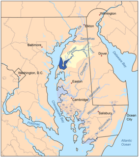
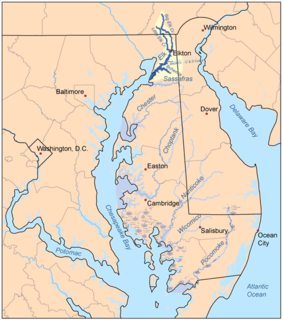
The Chester River is a major tributary of the Chesapeake Bay on the Delmarva Peninsula. It is about 43 miles (69 km) long, and its watershed encompasses 368 sq mi (950 km2), which includes 295 sq mi (760 km2) of land. Thus the total watershed area is 20% water. It forms the border between Kent County and Queen Anne's County, Maryland, with its headwaters extending into New Castle County and Kent County, Delaware. Chestertown, the seat of Maryland's Kent County, is located on its north shore. It is located south of the Sassafras River and north of Eastern Bay, and is connected with Eastern Bay through Kent Narrows.
Maryland's Western Shore is an area of Maryland west of the Chesapeake Bay. Originally, it included all areas not on the Eastern Shore and some colonial and later state government functions were administered separately for each region. The term no longer identifies an official region of Maryland and is used in contrast to the "Eastern Shore", also known as the "Delmarva" peninsula separated from the Maryland northeast corner of mainland with northern Delaware in the north by the Chesapeake and Delaware Canal, heavily used by transiting cargo ships along the major East Coast port cities.
The Yeocomico River is a 1.1-mile-long (1.8 km) tidal tributary of the southern portion of the Potomac River in Virginia's Northern Neck. The Yeocomico forms the boundary between Westmoreland and Northumberland counties. Yeocomico is a Native American name roughly translated as "tossed to and fro by the waters." Others suggest it is an Algonquian word that means "four dwelling places" since the river has a branch on either side with each dividing into two large forks.
The Wicomico River is a 13.0-mile-long (20.9 km) tributary of the lower tidal portion of the Potomac River located in the U.S. state of Maryland south of Washington, DC. The river empties into the Potomac at Cobb Island and St. Margaret's Island. Its watershed area is 77 square miles (200 km2), with 2% impervious surface in 1994. in Charles, St. Mary's, and southern Prince George's counties. The lower section of the river forms part of the boundary between Charles and St. Mary's counties. The Wicomico River was designated a Scenic River under the Maryland Scenic River Act in 1968, and there are Scenic River Commissions for it in both Charles and St. Mary's counties.

Alloway Creek is a 23.2-mile-long (37.3 km) tributary of the Delaware River in Salem County, New Jersey in the United States. The name is a derivative of Allowas, an Indian chief. It has also been known by other names: Aloes River, Aloes Creek, Cotton River, Korten River, Short River, Monmouth River, Munmouth River, and Roiter's River.

Mattawoman Creek is a 30.0-mile-long (48.3 km) coastal-plain tributary to the tidal Potomac River with a mouth at Indian Head, Maryland, 20 miles (32 km) downstream of Washington, D.C. It comprises a 23-mile (37 km) river flowing through Prince George's and Charles counties and a 7-mile (11 km) tidal-freshwater estuary in Charles County. About three-fourths of its 94-square-mile (240 km2) watershed lies in Charles County, with the remainder in Prince George's County immediately to the north.
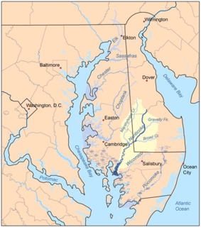
The Nanticoke River is a tributary of the Chesapeake Bay on the Delmarva Peninsula. It rises in southern Kent County, Delaware, flows through Sussex County, Delaware, and forms the boundary between Dorchester County, Maryland and Wicomico County, Maryland. The tidal river course proceeds southwest into the Tangier Sound, Chesapeake Bay. The river is 64.3 miles (103.5 km) long. A 26-mile ecotourism water trail running along the River was set aside in July 2011 by Delaware state and federal officials, contiguous with a 37-mile water-trail extending through Maryland to the Chesapeake Bay.
The Elk River is a tidal tributary of the Chesapeake Bay on the Eastern Shore of Maryland and on the northern edge of the Delmarva Peninsula. It is about 15 miles (24 km) long. As the most northeastern extension of the Chesapeake Bay estuary, it has served as one entrance to the Chesapeake & Delaware Canal since the 19th century. The canal and river now serve as one boundary of the Elk Neck Peninsula. The river flows through Cecil County, Maryland, with its watershed extending into New Castle County, Delaware and Chester County, Pennsylvania. Elkton, the county seat of Cecil County, is located at its head. Its total watershed area is 143 square miles (370 km2), with 21 square miles (54 km2) of open water, so its watershed is 15% open water. It is south and east of the North East River, and north of the Sassafras River.
The South River is a 10-mile-long (16 km) tributary of the Chesapeake Bay in Anne Arundel County, Maryland in the United States. It lies south of the Severn River, east of the Patuxent River, and north of the West River and Rhode River, and drains to the Chesapeake Bay.

Conewago Creek is an 80.2-mile-long (129.1 km) tributary of the Susquehanna River in Adams and York counties in Pennsylvania in the United States, with its watershed also draining a small portion of Carroll County, Maryland. The source is at an elevation of 1,440 feet (440 m), east of Caledonia State Park, in Franklin Township in Adams County. The mouth is the confluence with the Susquehanna River at York Haven in York County at an elevation of 259 feet (79 m).

Paint Branch is a 14.0-mile-long (22.5 km) stream that flows through Montgomery County and Prince George's County, Maryland. It is a tributary of the Northeast Branch, which flows to the Anacostia River, Potomac River and the Chesapeake Bay.
Pomonkey Creek is a 1.8-mile-long (2.9 km) tidal tributary of the Potomac River, near Bryans Road, Maryland. It is named for the Pamunkey tribe of Native Americans that lived in the area.
The Little Magothy River runs 2.5 miles (4.0 km) through Anne Arundel County in the U.S. state of Maryland. It is located southeast of the Magothy River, just outside its mouth and north of the Severn River.
The St. Martin River is a tributary of Isle of Wight Bay in Worcester County, Maryland. Approximately 4.4 miles (7.1 km) long, it drains the northernmost part of Worcester County.

Bush River is a tidal estuary in Harford County, Maryland, located about 15 mi (24 km) northeast of Baltimore. The estuary extends from the community of Riverside, south for about 9 mi (14 km), to the Chesapeake Bay. The watershed area of tidal Bush River is 125 mi2 (320 km2), and includes Aberdeen Proving Ground, a military facility.
Manokin River is a river in Somerset County, Maryland, that flows into Tangier Sound, an arm of the Chesapeake Bay. The Manokin rises east of Princess Anne, Maryland, flows through the town, then widens into a tidal estuary. Tributaries along the river's 17-mile (27 km) length are Kings Creek, Back Creek, St. Peters Creek, Broad Creek, and Fishing Creek. During the colonial period, the Manokin was navigable as far as Princess Anne.
The Green Branch of the Patuxent River in Prince George's County, Maryland is part of the Upper Patuxent Watershead. The stream passes centrally through the Governor Bridge Natural Area / Patuxent River Park and joins the Patuxent, just south of Governor's Bridge.

