
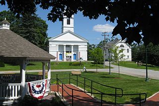
The North Attleborough Town Center Historic District encompasses the most historic elements of the central business district of North Attleborough, Massachusetts. The area was developed between about 1860 and 1830 as a center serving the community and the surrounding jewelry manufacturing businesses for which the town was well known. The district, extending along Washington Street between Fisher Street and Bruce Avenue, was added to the National Register of Historic Places in 1985.
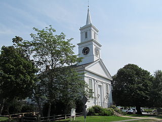
The Centerville Historic District is a historic district encompassing the heart of the village of Centerville in Barnstable, Massachusetts. The district extends along Main Street from a point north of its junction with Old Stage Road and Park Avenue, south to the junction with Church Hill Road. Most of the buildings in the district were built in the middle decades of the 19th century, although its oldest building, the Austin Bearse House, was built c. 1690. The area's growth was spurred by the relocation in 1826 of the Congregational Church building to its present location. The district was listed on the National Register of Historic Places in 1987.

The Cotuit Historic District is a historic district encompassing the heart of the village of Cotuit in Barnstable, Massachusetts. It extends along Main Street from Lowell Street in the north to Sea Street in the south, and includes portions of Ocean View Avenue and properties on adjacent roads. The oldest properties date to the late 18th century, but saw its greatest development during the height of the area's maritime industry in the mid 19th century. In the late 19th and early 20th century the area saw new development as a summer resort area. The district was listed on the National Register of Historic Places in 1987.

The South Yarmouth/Bass River Historic District is a historic district in the southeastern part of Yarmouth, Massachusetts. It encompasses a predominantly residential area centered on a portion of Old Main Street and South Street between the villages of South Yarmouth and Bass River. The area's history is one of maritime-related industry from the late 18th to late 19th century, and then its growth as a tourist resort community. The district was listed on the National Register of Historic Places in 1990.

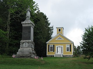
North Becket Village Historic District is a historic district encompassing the historic village of North Becket in the Berkshire hill town of Becket, Massachusetts. The village developed rapidly as the main economic and civic center of the town in a 20-year period beginning in 1841 with the arrival of the Western Railroad, and retains many fine examples of Greek Revival architecture. It was listed on the National Register of Historic Places in 1988.

The Charlemont Village Historic District is a historic district on Massachusetts Route 2 between South Street and Harmony Lane, encompassing much of the village center of Charlemont, Massachusetts, United States. The district's properties represent the growth of the village center from its rural origin through a period of 19th century industrialization, including 18th and 19th century farmsteads, Greek Revival buildings of the mid 19th century, and later 19th century Victorian architectural styles. The district was added to the National Register of Historic Places in 1988.

The Bradstreet Historic District encompasses the rural 19th-century village of Bradstreet in Hatfield, Massachusetts. It is centered at the junction of Depot Road and Main Street, and includes properties lining those two streets and Old Farm Road. Most of the buildings in the area date to the second half of the 19th century, featuring architectural styles typical of the period, including Queen Anne, Second Empire, Italianate, and Colonial Revival. The village grew on land that was originally granted to colonial governor Simon Bradstreet and divided in 1682, and has remained largely agricultural since then. The district was listed on the National Register of Historic Places in 1997.

The Memorial Square District encompasses the historic heart of the Memorial Square neighborhood of Springfield, Massachusetts. Arrayed around the Memorial Square at the junction of Main and Plainfield Streets are seven buildings of architectural and/or historic significance, including the Memorial Church, and the former Memorial Square Branch Library, now a Greek cultural center. It was added to the National Register of Historic Places in 1977.

The Beverly Center Business District encompasses much of the historic 19th century commercial heart of Beverly, Massachusetts. Centered on Cabot and Church Streets between Central Street and the Beverly Common, its architecture reflects the city's growth over 150 years. The district was added to the National Register of Historic Places in 1984.

The Compo–Owenoke Historic District encompasses an early 20th-century summer resort beach community in Westport, Connecticut. Developed between 1910 and 1940, the Compo Beach area contains one of the largest assemblages of period resort architecture in Westport, and one of the best such collections in the region. The district, covering 154 acres (62 ha) south of Compo Road South, was listed on the National Register of Historic Places in 1991.
The Kings Highway North Historic District is a predominantly residential 58-acre (23 ha) historic district in Westport, Connecticut. Located on the hillside west of the Saugatuck River, this area encapsulates architecturally several major stages in the community's development, from colonial days to the 20th century. It was listed on the National Register of Historic Places in 1998.
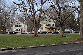
The Washington Street Historic District encompasses a residential area of Middletown, Connecticut that has a long history as a fashionable and desirable neighborhood. Extending along Washington Street and Washington Terrace between Main and Jackson Streets, the area has a broad diversity of residential architecture dating from 1752 to 1931, reflecting the city's patterns of growth. The district was listed on the National Register of Historic Places in 1985.

The Jewell Town District of South Hampton, New Hampshire, encompasses a colonial-era industrial village with a history dating to 1687. It is centered at the junction of West Whitehall and Jewell Streets, which is just south of a bend in the Powwow River, the source of the power for the mills that were built here. The area was settled in 1687 by Thomas Jewell, and by the early 19th century included a variety of mills as well as a bog iron works. The district now includes only remnants of its industrial past, and features a collection of 18th and early-19th century residential architecture. The district was listed on the National Register of Historic Places in 1983.
The Dennysville Historic District encompasses the historic town center of Dennysville, Maine. Located near the southern end of the large rural community, its architecture covers more than 100 years of community history, from the early 19th to early 20th centuries. The district extends along Main Street between Maine State Route 86 and Bunker Hill Road, on the west bank of the Dennys River. It was listed on the National Register of Historic Places in 1982.
The Federal Street Historic District of Brunswick, Maine encompasses a part of the town whose development was influenced by its 18th-century success as a shipping center, and by the presence of Bowdoin College, whose historic central campus is part of the district. In addition to the campus, the district includes a series of relatively high-style Federal and later-period houses along Federal Street and Maine Street, which join the campus to downtown Brunswick. The district was listed on the National Register of Historic Places in 1976.

The Grafton Village Historic District encompasses the historic village center of the town of Grafton, Vermont. The village was developed in the early-to-mid 19th century, and has retained the character of that period better than many small communities in the state. The district was listed on the National Register of Historic Places in 2010.

The Plainfield Village Historic District encompasses a significant portion of the village of Plainfield, Vermont. Located in northernmost Plainfield on United States Route 2, the village grew in the 19th century as a mill town and service community for the surround agricultural areas, and has a well-preserved collection of Greek Revival and Italianate architecture. It was listed on the National Register of Historic Places in 1983.

The Cove Street Historic District encompasses a small 19th-century neighborhood area of Duxbury, Massachusetts. Located along Cove Street north of the town center, it was developed in the early 19th century to provide housing for workers in nearby shipyards. The architecture of the district includes a variety of single-family housing styles common to the region and time period. The district was added to the National Register of Historic Places in 2019.
The Oakham Center Historic District encompasses a portion of the historic town center of Oakham, Massachusetts. Roughly bounded by Coldbrook Rd., Maple St., Barre Rd., and Deacon Allen Drive, the area was formed as a civic center about 1770, with town incorporation following in 1775. It includes a well-preserved variety of early 19th-century residential architecture, as well as the town's Greek Revival Congregational church, and its 1908 library. The district was listed on the National Register of Historic Places in 2020.
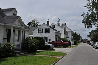
The South Chatham Village Historic District is a historic district encompassing much of the linear village of South Chatham in Chatham, Massachusetts. Extending eastward from the Harwich town line along Main Street, the district developed in the 18th and 19th centuries as a maritime and farming village. The district was listed on the National Register of Historic Places in 2022.


