
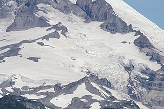
Emmons Glacier is on the northeast flank of Mount Rainier, in Washington. At 4.3 sq mi (11 km2), it has the largest surface area of any glacier in the contiguous United States. The glacier was named after the geologist Samuel Franklin Emmons after his involvement in a survey of Mount Rainier in 1870.

Boulder Glacier is located on the southeast slope of Mount Baker, a stratovolcano near the Pacific coast of North America in the Cascade Range of Washington. Boulder Glacier is the sixth largest on Mount Baker with an area of 1.3 square miles (3.4 km2). It flows from the summit crater between Grant Peak and Sherman Peak to about 5,000 ft (1,500 m). It is noteworthy for retreating 1,610 ft (490 m) between 1987 and 2008, leaving newly exposed rock and soil behind.

Maclure Glacier is on Mount Maclure in the Sierra Nevada crest of Yosemite National Park in Tuolumne County, California, United States. The glacier is named after William Maclure. Like most glaciers in the Sierra Nevada, Maclure Glacier is a small cirque glacier that is .20 mi (0.32 km) long and covers an area of only .08 sq mi (0.21 km2). The mean elevation of the glacier is around 11,400 ft (3,500 m). Both the Maclure Glacier and the Lyell Glacier, located nearby on Mount Lyell, have retreated since their first discovery.

Fryingpan Glacier is on the eastern face of the 11,138-foot (3,395 m) Little Tahoma Peak, just to the east of Mount Rainier in the U.S. state of Washington. The glacier is located on top of a cliff from the Emmons Glacier to the north and a small ridge separates this glacier from the Whitman Glacier to the south, except for a small snowfield in which these two glaciers are connected. Most of the ice is located on a broad plateau at an elevation of 8,000 to 8,600 feet. The head of the Fryingpan Glacier is located to the northeast of the ridge and at the foothill of Little Tahoma Peak at around 9,100 to 9,800 feet. The glacier flows downhill eastward and the uneven topography causes the glacier surface to be crevassed The glacier ends on shallow to steep slopes at about 7,100 to 7,500 feet. Numerous snowfields and alpine meadows are located near the bottom and east of the glacier. Meltwater from the glacier drains into the White River.
The Cowlitz Glacier is on the southeast flank of Mount Rainier in the U.S. state of Washington. The body of ice covers 1.3 square miles (3.4 km2) and has a volume of 6 billion ft3. The glacier starts at an elevation of 10,700 feet (3,300 m) and flows southeast. An adjacent glacier, the Paradise Glacier, is connected to this glacier on its southwest margin. As it flows down the slopes of Mount Rainier it nearly meets up with the Ingraham Glacier and during the Little Ice Age, which ended around the year 1850, the two glaciers shared a common terminus. Meltwater from the glacier drains into the Cowlitz River.
Flett Glacier refers to two glaciers on the northwestern flank of Mount Rainier in the U.S. state of Washington. The glaciers lie on a subsidiary peak of Rainier, the 8,364 feet (2,549 m) Observation Rock. There are two sections of glacial ice, an eastern lobe at about 7,600 ft (2,300 m) to 7,300 ft (2,200 m) in elevation, a smaller western lobe at about 7,200 ft (2,200 m) in elevation. Meltwater from the glacier flows into the Puyallup River.

Adams Glacier is situated on the northwest flank of Mount Adams, a 12,281-foot (3,743 m) stratovolcano in the U.S. state of Washington. Much of it becomes the source of Adams Creek, a tributary of the Cispus River. It is the largest glacier on Mount Adams, and the second largest in the contiguous United States, flowing down from the summit ice cap at over 12,000 feet (3,700 m) for over 2.5 miles (4.0 km) to a terminus near 7,000 feet (2,100 m).

Rusk Glacier is located on the eastern face of Mount Adams in the U.S. state of Washington. Starting at an elevation of over 10,200 ft (3,100 m) at just below The Castle, the glacier flows eastward down slope. A significant portion of the glacier is covered by rock debris and in the middle of the glacier, at about 9,200 ft (2,800 m), there is a small ice-free island of rock. The glacier terminates at about 7,500 ft (2,300 m) at its rock-covered moraine. The glacier has decreased in surface area by 23 percent between 1904 and 2006.
Crescent Glacier is located on the southeast slopes of Mount Adams in the U.S. state of Washington in Gifford Pinchot National Forest. A small subpeak of Mount Adams, named South Butte, rises nearby. Crescent Glacier is close to the Gotchen Glacier which is located just to the east. Crescent Glacier lies in a small south-facing cirque with a steep headwall. The glacier ranges in elevation from 8,400 ft (2,600 m) at the foot of the steep cliff to 7,900 ft (2,400 m) at the moraine. One arm of the glacier extends south down to 7,600 ft (2,300 m). Between 1904 and 2006, Crescent Glacier lost 6 percent of its surface area.
Blue Glacier is a large glacier located to the north of Mount Olympus in the Olympic Mountains of Washington. The glacier covers an area of 1.7 sq mi (4.4 km2) and contains 580,000,000 cu ft (16,000,000 m3) of ice and snow in spite of its low terminus elevation. The glacier length has decreased from about 3.4 mi (5.5 km) in 1800 to 2.7 mi (4.3 km) in the year 2000. Just in the period from 1995 and 2006, Blue Glacier retreated 325 ft (99 m). Blue Glacier is also thinning as it retreats and between 1987 and 2009 the glacier lost 178 ft (54 m) of its depth near its terminus and between 32 and 48 ft in the uppermost sections of the glacier known as the accumulation zone.
Ice River Glacier is located 2.4 miles (3.9 km) northeast of Mount Olympus in the Olympic Mountains of Olympic National Park in the U.S. state of Washington. Starting at an elevation of 6,400 feet (2,000 m) on the northern slope of a subpeak of Mount Olympus known as Mercury, the glacier flows northwest as it descends. The glacier reaches as low as 5,200 ft (1,600 m) before terminating. Though the glacier lies adjacent to the much larger Blue Glacier, an arête separates the two glaciers.
Queets Glacier is located in the Olympic Mountains in Olympic National Park in the U.S. state of Washington. The glacier lies on the northwest side of Mount Queets at an elevation of about 5,564 feet (1,696 m), the glacier descends northwest, bounded by two arêtes on either side. The ice reaches as low as 5,000 ft (1,500 m) before terminating and giving rise to the headwaters of the Queets River.
Gotchen Glacier is located on the south slopes of Mount Adams a stratovolcano in the Gifford Pinchot National Forest in the U.S. state of Washington. The glacier descends from approximately 8,200 ft (2,500 m) to a terminus near 7,400 ft (2,300 m) below which an old terminal moraine and proglacial lake exist. Gotchen Glacier has been in a general state of retreat for over 100 years and lost 78 percent of its surface area between 1904 and 2006.
Klickitat Glacier is located on the east slopes of Mount Adams a stratovolcano in the U.S. state of Washington. Though within the Mount Adams Wilderness, the glacier is situated within the boundaries of the Yakama Indian Reservation. The glacier descends from approximately 12,000 ft (3,700 m) to a terminus near 7,200 ft (2,200 m) below which an old lateral moraine once was the northern margin of the glacier. Klickitat Glacier has been in a general state of retreat for over 100 years and lost 46 percent of its surface area between 1904 and 2006.
Lava Glacier is located on the north slopes of Mount Adams a stratovolcano in Gifford Pinchot National Forest in the U.S. state of Washington. The glacier descends from approximately 10,000 ft (3,000 m) to a terminus near 7,800 ft (2,400 m). Lava Glacier has been in a general state of retreat for over 100 years and lost 74 percent of its surface area between 1904 and 2006.

Lyman Glacier is located on the north slopes of Mount Adams a stratovolcano in Gifford Pinchot National Forest in the U.S. state of Washington. The glacier is also within the Yakama Indian Reservation and descends from near the summit of Mount Adams at approximately 11,400 ft (3,500 m) to a terminus near 7,800 ft (2,400 m). Below 9,000 ft (2,700 m) the glacier splits into three distinct lobes. Lyman Glacier has been in a general state of retreat for over 100 years and lost 34 percent of its surface area between 1904 and 2006.

Mazama Glacier is located on the southeast slopes of Mount Adams a stratovolcano in the U.S. state of Washington. Mazama Glacier is in the Yakama Indian Reservation. The glacier descends from approximately 10,800 ft (3,300 m) to a terminus near 7,600 ft (2,300 m). Mazama Glacier has been in a general state of retreat for over 100 years and lost 46 percent of its surface area between 1904 and 2006.

Pinnacle Glacier is located on the west slopes of Mount Adams a stratovolcano in Gifford Pinchot National Forest in the U.S. state of Washington. The glacier descends from approximately 10,000 ft (3,000 m) to a terminus near 7,200 ft (2,200 m). Pinnacle Glacier lost 7 percent of its surface area between 1904 and 2006.
Wilson Glacier is located on the east slopes of Mount Adams a stratovolcano in the U.S. state of Washington. The glacier is within the Yakama Indian Reservation. The glacier descends from approximately 10,600 ft (3,200 m) to a terminus near 7,400 ft (2,300 m). Wilson Glacier has been in a general state of retreat for over 100 years and lost 14 percent of its surface area between 1904 and 2006.


