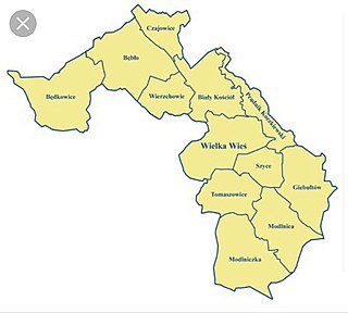
Gmina Wielka Wieś is a rural gmina in Kraków County, Lesser Poland Voivodeship, in southern Poland. Its seat is the village of Wielka Wieś, which lies approximately 13 kilometres (8 mi) north-west of the regional capital Kraków.
Gmina Zielonki is a rural gmina in Kraków County, Lesser Poland Voivodeship, in southern Poland. Its seat is the village of Zielonki, which lies approximately 7 kilometres (4 mi) north of the regional capital Kraków.
Gmina Książ Wielki is a rural gmina in Miechów County, Lesser Poland Voivodeship, in southern Poland. Its seat is the village of Książ Wielki, which lies approximately 13 kilometres (8 mi) north-east of Miechów and 45 km (28 mi) north of the regional capital Kraków.
Gmina Łabowa is a rural gmina in Nowy Sącz County, Lesser Poland Voivodeship, in southern Poland. Its seat is the village of Łabowa, which lies approximately 16 kilometres (10 mi) south-east of Nowy Sącz and 89 km (55 mi) south-east of the regional capital Kraków.

Kraków Valleys Landscape Park is a protected area in southern Poland, covering an area of 197.77 square kilometres (76.36 sq mi). Within the Landscape Park are five nature reserves.

Tenczynek Landscape Park is a protected area in southern Poland, established in 1981, and covering an area of 117.47 square kilometres (45.36 sq mi).
Wielka Wieś may refer to the following places:

Rawałowice is a village in the administrative district of Gmina Kocmyrzów-Luborzyca, within Kraków County, Lesser Poland Voivodeship, in southern Poland. It lies approximately 20 km (12 mi) north-east of the regional capital Kraków.
Bębło is a village in the administrative district of Gmina Wielka Wieś, within Kraków County, Lesser Poland Voivodeship, in southern Poland. It lies approximately 18 km (11 mi) north-west of the regional capital Kraków.
Będkowice is a village in the administrative district of Gmina Wielka Wieś, within Kraków County, Lesser Poland Voivodeship, in southern Poland. It lies approximately 18 km (11 mi) north-west of the regional capital Kraków.
Biały Kościół is a village in the administrative district of Gmina Wielka Wieś, within Kraków County, Lesser Poland Voivodeship, in southern Poland. It lies approximately 15 km (9 mi) north-west of the regional capital Kraków.
Czajowice is a village in the administrative district of Gmina Wielka Wieś, within Kraków County, Lesser Poland Voivodeship, in southern Poland. It lies approximately 19 km (12 mi) north-west of the regional capital Kraków.
Giebułtów is a village in the administrative district of Gmina Wielka Wieś, within Kraków County, Lesser Poland Voivodeship, in southern Poland. It lies approximately 10 km (6 mi) north-west of the regional capital Kraków. The village is located in the historical region Galicia.
Modlnica is a village in the administrative district of Gmina Wielka Wieś, within Kraków County, Lesser Poland Voivodeship, in southern Poland. It lies approximately 10 km (6 mi) north-west of the regional capital Kraków.
Modlniczka is a village in the administrative district of Gmina Wielka Wieś, within Kraków County, Lesser Poland Voivodeship, in southern Poland. It lies approximately 9 km (6 mi) north-west of the regional capital Kraków.
Prądnik Korzkiewski is a village in the administrative district of Gmina Wielka Wieś, within Kraków County, Lesser Poland Voivodeship, in southern Poland.
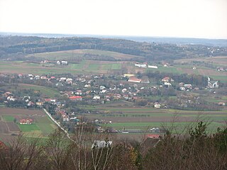
Tomaszowice is a village in the administrative district of Gmina Wielka Wieś, within Kraków County, Lesser Poland Voivodeship, in southern Poland. It lies approximately 3 kilometres (2 mi) south of Wielka Wieś and 11 km (7 mi) north-west of the regional capital Kraków. The village is located in the historical region Galicia.
Wierzchowie is a village in the administrative district of Gmina Wielka Wieś, within Kraków County, Lesser Poland Voivodeship, in southern Poland. It lies approximately 16 km (10 mi) north-west of the regional capital Kraków.
Wielka Wieś is a village in the administrative district of Gmina Książ Wielki, within Miechów County, Lesser Poland Voivodeship, in southern Poland. It lies approximately 2 kilometres (1 mi) east of Książ Wielki, 14 km (9 mi) north-east of Miechów, and 46 km (29 mi) north of the regional capital Kraków.
Wielka Wieś is a village in the administrative district of Gmina Wojnicz, within Tarnów County, Lesser Poland Voivodeship, in southern Poland. It lies approximately 4 kilometres (2 mi) south of Wojnicz, 18 km (11 mi) south-west of Tarnów, and 65 km (40 mi) east of the regional capital Kraków.


