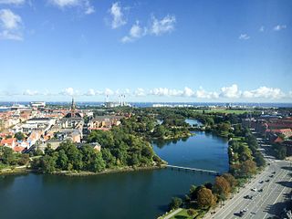
Stadsgraven is the canal which separates Christianshavn from the rest of Amager in Copenhagen, Denmark. It was originally a moat located in front of the Christianshavn Rampart as part of the city's Bastioned Ring Fortifications.

Holmens Kanal is a short street in central Copenhagen. Part of the main thoroughfare of the city centre, it extends from Kongens Nytorv for one block to a junction with a statue of Niels Juel where it turns right towards Holmens Bro while the through traffic continues straight along Niels Juels Gade. The street was originally a canal, hence the name, but was filled in the 1860s. Today it is dominated by bank and government buildings.

The Royal Horse Guards Barracks, at 26 Frederiksholms Kanal in Copenhagen, Denmark, served as barracks for the Royal Horse Guards from 1792 until 1866. The building is located along the south side of a gated alleyway which connects Frederiksholm Canal to Vester Voldgade. Together with Civiletatens Materialgård and Fæstningens Materialgård, it forms a cluster of low, yellow-washed buildings all of which are listed, on the Zealand side of the canal, opposite the small island Slotsholmen with Christiansborg Palace. The Hay Storage Building at the end of the barracks building, facing Vester Voldgade, originally stored hay for the King's horses at the Royal Stables but later also served the Royal Horse Guards. Both the Royal Horse Guards Barracks and the Hay Storage building are now used by the Ministry of Education.

Stanley House is a Rococo mansion overlooking Christianshavn Canal in the Christianshavn neighbourhood of Copenhagen, Denmark. The house takes its name after its founder, Simon Carl Stanley, and was possibly built to his own design.

Steinfass House is a listed house overlooking Christianshavn Canal in the Christianshavn neighbourhood of Copenhagen, Denmark. It is now part of the Sofiegården hall of residence.
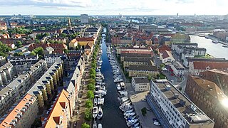
Christianshavns Torv is the central public square of the Christianshavn neighborhood in Copenhagen, Denmark. It is situated at the intersection of Torvegade and Christianshavn Canal, roughly at the center of the area.

Applebyes Plads is a triangular area located between Langebro Bridge and the southernmost portion of Christianshavn Canal at the southern tip of the Christianshavn neighbourhood in Copenhagen, Denmark. The area takes its name from Peter Applebye, Christian VI's rope maker, who ran his manufactury from the site in the late 18th century, although no buildings remain from that time. The Danish Sugar Factories' building along the waterfront dates from 1912 while the rest of the grounds have undergone residential redevelopment in later years.

Sankt Annæ Gade is a street in the Christianshavn district of Copenhagen, Denmark. It connects the main harbourfront at Asiatisk Plads in the west to Christianshavn Rampart in the east by of the Snorrebroen bridge. Church of Our Saviour is located in the street.

Torvegade is the central thorughfare of Christianshavn in Copenhagen, Denmark, linking the city centre by way of Knippel Vridge with Amagerside Copenhagen at Christmas Møllers Plads. The street crosses Christianshavn Canal at Christianshavns Torv, the central square of the neighbourhood. The last section of the street runs on the embankment that across Stadsgraven.

Treschows Stiftelse is a listed, philanthropical housing complex in the Christianshavn district of Copenhagen, Denmark.

Wildersgade Barracks was a barracks which existed from 1802 until 1822 in the Christianshavn district of Copenhagen, Denmark. Its former premises, which include a purpose-built main building on Wildersgade and converted warehouses, two of them facing Christianshavn Canal, are now listed. They surround a central courtyard which has been converted into a community garden.

Dronningensgade is a street in the Christianshavn district of Copenhagen, Denmark, running parallel to Christianshavn Canal one block to the east, from Christianshavn Rampart in the south to Bådsmandsstræde in the north.

Strandgade is one of the principal streets in the Christianshavn district of Copenhagen, Denmark. It runs along the full length of the neighbourhood, following the harbourfront, from Christian's Church in the south-west to Grønlandske Handels Plads in the north

Stormgade is a street in central Copenhagen, Denmark. It runs from Frederiksholm Canal to H. C. Andersens Boulevard where it turns into Tietgensgade before continuing along the rear side of Tivoli Gardens and Copenhagen Central Station. In the opposite direction, Storm Bridge connects it to Slotsholmen where traffic may continue across Holmen's Bridge to Holmens Kanal, part of Ring 2, or across Knippel's Bridge to Christianshavn and Amager. The name of the street refers to the Swedish Storm of Copenhagen in 1659.
Sofiegade is a street in the Christianshavn neighbourhood of central Copenhagen, Denmark. It runs from Christianshavns Kanal in the northwest to Christianshavns Voldgade and Christianshavns Vold in the southeast, passing Dronningensgade and Prinsessegade on the way.

Bodenhodds Plads is an area located in the north-eastern part of Christianshavn, Copenhagen, Denmark. The site is separated from Grønlandske Handels Plads to the west by Christianshavns Kanal and by Trangraven from Holmen to the north. It is connected to both areas by the three-way footbridge Trangravsbroen.

The Andreas Bjørn House is a historic property located at the corner of Strandgade and Bådsmandsstræde in the Christianshavn neighbourhood of Copenhagen, Denmark. It was built for Andreas Bjørn in 1734 and listed on the Danish registry of protected buildings and places in 1918. A sufar refinery named Union House was from 1771 to 1811 licated in a now demolished warehouse afjacent to the building by a group of British merchants and plantation owners from St. Croix in the Danish West Indies.