This page is based on this
Wikipedia article Text is available under the
CC BY-SA 4.0 license; additional terms may apply.
Images, videos and audio are available under their respective licenses.

The Reclamation Act of 1902 is a United States federal law that funded irrigation projects for the arid lands of 20 states in the American West.
Jamestown often refers to:

Yankton County is a county in the U.S. state of South Dakota. As of the 2010 United States Census, the population was 22,438. Its county seat is Yankton. Yankton County comprises the Yankton, SD Micropolitan Statistical Area.

The Dolores River is a tributary of the Colorado River, approximately 241 miles (388 km) long, in the U.S. states of Colorado and Utah. The river drains a rugged and arid region of the Colorado Plateau west of the San Juan Mountains. Its name derives from the Spanish El Rio de Nuestra Señora de Dolores, River of Our Lady of Sorrows. The river was explored and possibly named by Juan Maria Antonio Rivera during a 1765 expedition from Santa Fe.

Horsetooth Reservoir is a large reservoir in southern Larimer County, Colorado, just west of the city of Fort Collins, Colorado. The reservoir sits in the foothills above the town on the western side of the Dakota Hogback, which contains the reservoir along its eastern side. The reservoir runs north-south for approximately 6.5 miles (10 km) and is approximately one-half mile (1 km) wide. It was constructed in 1949 by the Bureau of Reclamation as part of its federal Colorado-Big Thompson Project or "C-BT". Water distribution is currently managed by Reclamation and operated by the Northern Colorado Water Conservancy District. Horsetooth and Carter Lake serve as the two principal reservoirs for water diverted eastward under the continental divide via the C-BT.

The National Register of Historic Places in the United States is a register including buildings, sites, structures, districts, and objects. The Register automatically includes all National Historic Landmarks as well as all historic areas administered by the U.S. National Park Service. Since its introduction in 1966, more than 90,000 separate listings have been added to the register.
After a 1944 United States Mexico Treaty the Morelos Dam was built in 1950 across the Colorado River. It is located about 1 mile (1.6 km) below the junction of the California border and the Colorado River between the town of Los Algodones, Baja California, in northwestern Mexico and Yuma County, Arizona in the southwestern United States. The eastern half of the dam lies inside United States territory; but Mexico is responsible for all maintenance. The dam allows Mexico to divert its allotted water from the Colorado River to highly developed crop lands in the Mexicali, Mexico Valley. The Morelos Dam is the final dam on the Colorado River. It is run by the International Boundary and Water Commission (IBWC).

The Dakota Formation is a geologic formation composed of sedimentary rocks deposited in the late-Early to early-Late Creteceous Western Interior Seaway. F.B. Meek and F.V. Hayden first applied the name to red sandstone exposures along the Missouri River near Dakota City, Nebraska. Dakota Formation is a primary usage in the Great Plains, while Dakota or Dakota Sandstone is used in the context of the Mancos Shale members of the Southwest. The Dakota Group classification is employed along the territory of the Dakota Hogback in Colorado and Wyoming, but includes additional older ages of formations than are usually included elsewhere under the Dakota name.
Sand County Foundation is a non-profit private land conservation organization located in Madison, Wisconsin, United States. Founded in 1965, its work is inspired by world-renowned conservationist Aldo Leopold’s land ethic.

The Lower Colorado River Valley ("LCRV") is the river region of the lower Colorado River of the southwestern United States in North America that rises in the Rocky Mountains and has its outlet at the Colorado River Delta in the northern Gulf of California in northwestern Mexico, between the states of Baja California and Sonora. This north–south stretch of the Colorado River forms the border between the U.S. states of California/Arizona and Nevada/Arizona, and between the Mexican states of Baja California/Sonora.
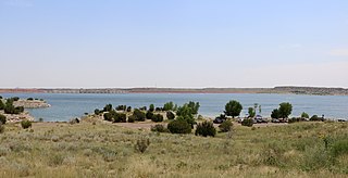
Lake Pueblo State Park is a state park located in Pueblo County, Colorado. It includes 60 miles (97 km) of shoreline and 10,000 acres (40 km2) of land. Activities it offers include two full-service marinas, recreational fishing, hiking, camping and swimming at a special swim beach.
Dakota Lake National Wildlife Refuge is a National Wildlife Refuge in North Dakota. It is managed under Kulm Wetland Management District.

Lake San Cristobal is a lake in the U.S. state of Colorado. Located in the San Juan Mountains at an elevation of 9,003 feet (2,744 m), the freshwater lake is 2.1 miles (3.4 km) long, up to 89 feet (27 m) deep, has a surface area of 0.52 square miles (1.3 km2), and holds about 11,000 acre feet (14,000,000 m3) of water. The town of Lake City, a few miles to the north, is named after Lake San Cristobal. The name San Cristóbal means Saint Christopher in the Spanish language. Many old silver mines are near the lake and it is very clean and well kept, and stocked with Rainbow Trout.