Wind shear

Last updated
Cirrus uncinus ice crystal plumes showing high-level wind shear, with changes in wind speed and direction Cirrus clouds2.jpg
Cirrus uncinus ice crystal plumes showing high-level wind shear, with changes in wind speed and direction

Wind shear (or windshear), sometimes referred to as wind gradient, is a difference in wind speed and/or direction over a relatively short distance in the atmosphere. Atmospheric wind shear is normally described as either vertical or horizontal wind shear. Vertical wind shear is a change in wind speed or direction with a change in altitude. Horizontal wind shear is a change in wind speed with a change in lateral position for a given altitude. [1]

Contents

Wind shear is a microscale meteorological phenomenon occurring over a very small distance, but it can be associated with mesoscale or synoptic scale weather features such as squall lines and cold fronts. It is commonly observed near microbursts and downbursts caused by thunderstorms, fronts, areas of locally higher low-level winds referred to as low-level jets, near mountains, radiation inversions that occur due to clear skies and calm winds, buildings, wind turbines, and sailboats. Wind shear has significant effects on the control of an aircraft, and it has been the sole or a contributing cause of many aircraft accidents.

Sound movement through the atmosphere is affected by wind shear, which can bend the wave front, causing sounds to be heard where they normally would not. Strong vertical wind shear within the troposphere also inhibits tropical cyclone development but helps to organize individual thunderstorms into longer life cycles which can then produce severe weather. The thermal wind concept explains how differences in wind speed at different heights are dependent on horizontal temperature differences and explains the existence of the jet stream. [2]

Down draft winds with associated virga allow these clouds in the eastern sky at civil twilight to mimic aurora borealis in the Mojave desert. Downdraft Wind shear-2.jpg
Down draft winds with associated virga allow these clouds in the eastern sky at civil twilight to mimic aurora borealis in the Mojave desert.

Definition

Wind shear refers to the variation of wind velocity over either horizontal or vertical distances. Airplane pilots generally regard significant wind shear to be a horizontal change in airspeed of 30 knots (15 m/s) for light aircraft, and near 45 knots (23 m/s) for airliners at flight altitude. [3] Vertical speed changes greater than 4.9 knots (2.5 m/s) also qualify as significant wind shear for aircraft. Low-level wind shear can affect aircraft airspeed during takeoff and landing in disastrous ways, and airliner pilots are trained to avoid all microburst wind shear (headwind loss in excess of 30 knots [15 m/s]). [4] The rationale for this additional caution includes:[ citation needed ]

Wind shear is also a key factor in the formation of severe thunderstorms. The additional hazard of turbulence is often associated with wind shear.[ citation needed ]

Occurrence

Microburst schematic from NASA. The direction of travel is downward until the air current hits ground level, at which point it spreads outward in all directions. The wind regime in a microburst is completely opposite to a tornado. Microburstnasa.JPG
Microburst schematic from NASA. The direction of travel is downward until the air current hits ground level, at which point it spreads outward in all directions. The wind regime in a microburst is completely opposite to a tornado.

Weather situations where shear is observed include:

Horizontal component

Weather fronts

Weather fronts are boundaries between two masses of air of different densities, or different temperature and moisture properties, which normally are convergence zones in the wind field and are the principal cause of significant weather. Within surface weather analyses, they are depicted using various colored lines and symbols. The air masses usually differ in temperature and may also differ in humidity. Wind shear in the horizontal occurs near these boundaries. Cold fronts feature narrow bands of thunderstorms and severe weather and may be preceded by squall lines and dry lines. Cold fronts are sharper surface boundaries with more significant horizontal wind shear than warm fronts. When a front becomes stationary, it can degenerate into a line that separates regions of differing wind speed, known as a shear line, though the wind direction across the front normally remains constant. In the tropics, tropical waves move from east to west across the Atlantic and eastern Pacific basins. Directional and speed shear can occur across the axis of stronger tropical waves, as northerly winds precede the wave axis and southeast winds are seen behind the wave axis. Horizontal wind shear can also occur along the local land breeze and sea breeze boundaries. [10]

Near coastlines

Wind shear along the coast with low-level clouds moving towards the east and higher-level clouds moving towards the south-west

The magnitude of winds offshore is nearly double the wind speed observed onshore. This is attributed to the differences in friction between landmasses and offshore waters. Sometimes, there are even directional differences, particularly if local sea breezes change the wind on shore during daylight hours. [11]

Vertical component

Thermal wind

Thermal wind is a meteorological term not referring to an actual wind, but a difference in the geostrophic wind between two pressure levels p1 and p0, with p1 < p0; in essence, wind shear. It is only present in an atmosphere with horizontal changes in temperature (or in an ocean with horizontal gradients of density), i.e., baroclinicity. In a barotropic atmosphere, where temperature is uniform, the geostrophic wind is independent of height. The name stems from the fact that this wind flows around areas of low (and high) temperature in the same manner as the geostrophic wind flows around areas of low (and high) pressure. [12]

The thermal wind equation is

where the φ are geopotential height fields with φ1 > φ0, f is the Coriolis parameter, and k is the upward-pointing unit vector in the vertical direction. The thermal wind equation does not determine the wind in the tropics. Since f is small or zero, such as near the equator, the equation reduces to stating that ∇(φ1φ0) is small. [12]

This equation basically describes the existence of the jet stream, a westerly current of air with maximum wind speeds close to the tropopause which is (even though other factors are also important) the result of the temperature contrast between equator and pole.[ citation needed ]

Effects on tropical cyclones

Strong wind shear in the high troposphere forms the anvil-shaped top of this mature cumulonimbus cloud, or thunderstorm. Thunderhead.anvil.jpg
Strong wind shear in the high troposphere forms the anvil-shaped top of this mature cumulonimbus cloud, or thunderstorm.

Tropical cyclones are, in essence, heat engines that are fueled by the temperature gradient between the warm tropical ocean surface and the colder upper atmosphere. Tropical cyclone development requires relatively low values of vertical wind shear so that their warm core can remain above their surface circulation center, thereby promoting intensification. Strongly sheared tropical cyclones weaken as the upper circulation is blown away from the low-level center.[ citation needed ]

Effects on thunderstorms and severe weather

Severe thunderstorms, which can spawn tornadoes and hailstorms, require wind shear to organize the storm in such a way as to maintain the thunderstorm for a longer period. This occurs as the storm's inflow becomes separated from its rain-cooled outflow. An increasing nocturnal, or overnight, low-level jet can increase the severe weather potential by increasing the vertical wind shear through the troposphere. Thunderstorms in an atmosphere with virtually no vertical wind shear weaken as soon as they send out an outflow boundary in all directions, which then quickly cuts off its inflow of relatively warm, moist air and causes the thunderstorm to dissipate. [14]

Planetary boundary layer

Depiction of where the planetary boundary layer lies on a sunny day PBLimage.jpg
Depiction of where the planetary boundary layer lies on a sunny day

The atmospheric effect of surface friction with winds aloft forces surface winds to slow and back counterclockwise near the surface of Earth blowing inward across isobars (lines of equal pressure) when compared to the winds in frictionless flow well above Earth's surface. [15] [ failed verification ] This layer where friction slows and changes the wind is known as the planetary boundary layer, sometimes the Ekman layer, and it is thickest during the day and thinnest at night. Daytime heating thickens the boundary layer as winds at the surface become increasingly mixed with winds aloft due to insolation, or solar heating. Radiative cooling overnight further enhances wind decoupling between the winds at the surface and the winds above the boundary layer by calming the surface wind which increases wind shear. These wind changes force wind shear between the boundary layer and the wind aloft and are most emphasized at night.[ citation needed ]

Effects on flight

Gliding
Glider ground launch affected by wind shear FAA-8083-13 Fig 7-20.PNG
Glider ground launch affected by wind shear

In gliding, wind gradients just above the surface affect the takeoff and landing phases of the flight of a glider. Wind gradient can have a noticeable effect on ground launches, also known as winch launches or wire launches. If the wind gradient is significant or sudden, or both, and the pilot maintains the same pitch attitude, the indicated airspeed will increase, possibly exceeding the maximum ground launch tow speed. The pilot must adjust the airspeed to deal with the effect of the gradient. [16]

When landing, wind shear is also a hazard, particularly when the winds are strong. As the glider descends through the wind gradient on final approach to landing, airspeed decreases while sink rate increases, and there is insufficient time to accelerate prior to ground contact. The pilot must anticipate the wind gradient and use a higher approach speed to compensate for it. [17]

Wind shear is also a hazard for aircraft making steep turns near the ground. It is a particular problem for gliders which have a relatively long wingspan, which exposes them to a greater wind speed difference for a given bank angle. The different airspeed experienced by each wing tip can result in an aerodynamic stall on one wing, causing a loss of control accident. [17] [18]

Parachuting

Wind shear or wind gradients are a threat to parachutists, particularly to BASE jumping and wingsuit flying. Skydivers have been pushed off of their course by sudden shifts in wind direction and speed, and have collided with bridges, cliffsides, trees, other skydivers, the ground, and other obstacles.[ citation needed ] Skydivers routinely make adjustments to the position of their open canopies to compensate for changes in direction while making landings to prevent accidents such as canopy collisions and canopy inversion.[ citation needed ]

Soaring

Soaring related to wind shear, also called dynamic soaring, is a technique used by soaring birds like albatrosses, who can maintain flight without wing flapping. If the wind shear is of sufficient magnitude, a bird can climb into the wind gradient, trading ground speed for height, while maintaining airspeed. [19] By then turning downwind, and diving through the wind gradient, they can also gain energy. [20] It has also been used by glider pilots on rare occasions.

Wind shear can also produce wave. This occurs when an atmospheric inversion separates two layers with a marked difference in wind direction. If the wind encounters distortions in the inversion layer caused by thermals coming up from below, it will produce significant shear waves that can be used for soaring. [21]

Impact on passenger aircraft
Effect of wind shear on aircraft trajectory. Note how merely correcting for the initial gust front can have dire consequences. Windshearaircraftnasa.gif
Effect of wind shear on aircraft trajectory. Note how merely correcting for the initial gust front can have dire consequences.
Wreckage of Delta Air Lines Flight 191 tail section after a microburst slammed the aircraft into the ground. Another aircraft can be seen flying in the background past the crash scene. Delta 191 wreckage.jpg
Wreckage of Delta Air Lines Flight 191 tail section after a microburst slammed the aircraft into the ground. Another aircraft can be seen flying in the background past the crash scene.

Windshear can be extremely dangerous for aircraft, especially during takeoff and landing. Sudden changes in wind velocity can cause rapid decreases in airspeed, leading to the aircraft being unable to maintain altitude. Windshear has been responsible for several deadly accidents, including Eastern Air Lines Flight 66, Pan Am Flight 759, Delta Air Lines Flight 191, and USAir Flight 1016.[ citation needed ]

Windshear can be detected using Doppler radar. [22] [23] [24] Airports can be fitted with low-level windshear alert systems or Terminal Doppler Weather Radar, and aircraft can be fitted with airborne wind shear detection and alert systems. Following the 1985 crash of Delta Air Lines Flight 191, in 1988 the U.S. Federal Aviation Administration mandated that all commercial aircraft have airborne wind shear detection and alert systems by 1993. The installation of high-resolution Terminal Doppler Weather Radar stations at many U.S. airports that are commonly affected by windshear has further aided the ability of pilots and ground controllers to avoid wind shear conditions. [25]

Sailing

Wind shear affects sailboats in motion by presenting a different wind speed and direction at different heights along the mast. The effect of low-level wind shear can be factored into the selection of sail twist in the sail design, but this can be difficult to predict since wind shear may vary widely in different weather conditions. Sailors may also adjust the trim of the sail to account for low-level wind shear, for example using a boom vang. [26]

Sound propagation

Wind shear can have a pronounced effect upon sound propagation in the lower atmosphere, where waves can be "bent" by refraction phenomenon. The audibility of sounds from distant sources, such as thunder or gunshots, is very dependent on the amount of shear. The result of these differing sound levels is key in noise pollution considerations, for example from roadway noise and aircraft noise, and must be considered in the design of noise barriers. [27] This phenomenon was first applied to the field of noise pollution study in the 1960s, contributing to the design of urban highways as well as noise barriers. [28]

Hodograph plot of wind vectors at various heights in the troposphere. Meteorologists can use this plot to evaluate vertical wind shear in weather forecasting. (Source: NOAA) Hodographe NOAA.PNG
Hodograph plot of wind vectors at various heights in the troposphere. Meteorologists can use this plot to evaluate vertical wind shear in weather forecasting. (Source: NOAA)

The speed of sound varies with temperature. Since temperature and sound velocity normally decrease with increasing altitude, sound is refracted upward, away from listeners on the ground, producing an acoustic shadow at some distance from the source. [29] In 1862, during the American Civil War Battle of Iuka, an acoustic shadow, believed to have been enhanced by a northeast wind, kept two divisions of Union soldiers out of the battle, [30] because they could not hear the sounds of battle only six miles downwind. [31]

Effects on architecture

Wind engineering is a field of engineering devoted to the analysis of wind effects on the natural and built environment. It includes strong winds which may cause discomfort as well as extreme winds such as tornadoes, hurricanes, and storms which may cause widespread destruction. Wind engineering draws upon meteorology, aerodynamics, and several specialist engineering disciplines. The tools used include climate models, atmospheric boundary layer wind tunnels, and numerical models. It involves, among other topics, how wind impacting buildings must be accounted for in engineering. [32]

Wind turbines are affected by wind shear. Vertical wind-speed profiles result in different wind speeds at the blades nearest to the ground level compared to those at the top of blade travel, and this, in turn, affects the turbine operation. [33] This low-level wind shear can cause a large bending moment in the shaft of a two-bladed turbine when the blades are vertical. [34] The reduced wind shear over water means shorter and less expensive wind turbine towers can be used in shallow seas. [35]

See also

Related Research Articles

<span class="mw-page-title-main">Cumulonimbus cloud</span> Genus of dense, towering vertical clouds

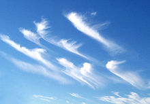
Cumulonimbus is a dense, towering vertical cloud, typically forming from water vapor condensing in the lower troposphere that builds upward carried by powerful buoyant air currents. Above the lower portions of the cumulonimbus the water vapor becomes ice crystals, such as snow and graupel, the interaction of which can lead to hail and to lightning formation, respectively. When occurring as a thunderstorm these clouds may be referred to as thunderheads. Cumulonimbus can form alone, in clusters, or along squall lines. These clouds are capable of producing lightning and other dangerous severe weather, such as tornadoes, hazardous winds, and large hailstones. Cumulonimbus progress from overdeveloped cumulus congestus clouds and may further develop as part of a supercell. Cumulonimbus is abbreviated Cb.

<span class="mw-page-title-main">Inversion (meteorology)</span> Deviation from the normal change of an atmospheric property with altitude

In meteorology, an inversion is a deviation from the normal change of an atmospheric property with altitude. It almost always refers to an inversion of the air temperature lapse rate, in which case it is called a temperature inversion. Normally, air temperature decreases with an increase in altitude, but during an inversion warmer air is held above cooler air.

<span class="mw-page-title-main">Surface weather analysis</span> Type of weather map

Surface weather analysis is a special type of weather map that provides a view of weather elements over a geographical area at a specified time based on information from ground-based weather stations.

<span class="mw-page-title-main">Squall</span> Short, sharp increase in wind speed

A squall is a sudden, sharp increase in wind speed lasting minutes, as opposed to a wind gust, which lasts for only seconds. They are usually associated with active weather, such as rain showers, thunderstorms, or heavy snow. Squalls refer to the increase of the sustained winds over that time interval, as there may be higher gusts during a squall event. They usually occur in a region of strong sinking air or cooling in the mid-atmosphere. These force strong localized upward motions at the leading edge of the region of cooling, which then enhances local downward motions just in its wake.

Dynamic soaring is a flying technique used to gain energy by repeatedly crossing the boundary between air masses of different velocity. Such zones of wind gradient are generally found close to obstacles and close to the surface, so the technique is mainly of use to birds and operators of radio-controlled gliders, but glider pilots are sometimes able to soar dynamically in meteorological wind shears at higher altitudes.

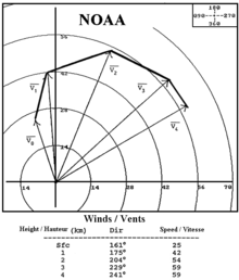
In common usage, wind gradient, more specifically wind speed gradient or wind velocity gradient, or alternatively shear wind, is the vertical component of the gradient of the mean horizontal wind speed in the lower atmosphere. It is the rate of increase of wind strength with unit increase in height above ground level. In metric units, it is often measured in units of meters per second of speed, per kilometer of height (m/s/km), which reduces inverse milliseconds (ms−1), a unit also used for shear rate.

<span class="mw-page-title-main">Downburst</span> Strong surface-level winds that radiate from a single point

In meteorology, a downburst is a strong downward and outward gushing wind system that emanates from a point source above and blows radially, that is, in straight lines in all directions from the area of impact at surface level. Capable of producing damaging winds, it may sometimes be confused with a tornado, where high-velocity winds circle a central area, and air moves inward and upward. These usually last for seconds to minutes. Downbursts are particularly strong downdrafts within thunderstorms.

<span class="mw-page-title-main">Planetary boundary layer</span> Lowest part of the atmosphere directly influenced by contact with the planetary surface

In meteorology, the planetary boundary layer (PBL), also known as the atmospheric boundary layer (ABL) or peplosphere, is the lowest part of the atmosphere and its behaviour is directly influenced by its contact with a planetary surface. On Earth it usually responds to changes in surface radiative forcing in an hour or less. In this layer physical quantities such as flow velocity, temperature, and moisture display rapid fluctuations (turbulence) and vertical mixing is strong. Above the PBL is the "free atmosphere", where the wind is approximately geostrophic, while within the PBL the wind is affected by surface drag and turns across the isobars.

<span class="mw-page-title-main">Cyclogenesis</span> The development or strengthening of cyclonic circulation in the atmosphere

Cyclogenesis is the development or strengthening of cyclonic circulation in the atmosphere. Cyclogenesis is an umbrella term for at least three different processes, all of which result in the development of some sort of cyclone, and at any size from the microscale to the synoptic scale.

<span class="mw-page-title-main">Thermal wind</span> Vector difference of geostrophic wind movement at high and low altitudes

In atmospheric science, the thermal wind is the vector difference between the geostrophic wind at upper altitudes minus that at lower altitudes in the atmosphere. It is the hypothetical vertical wind shear that would exist if the winds obey geostrophic balance in the horizontal, while pressure obeys hydrostatic balance in the vertical. The combination of these two force balances is called thermal wind balance, a term generalizable also to more complicated horizontal flow balances such as gradient wind balance.

<span class="mw-page-title-main">Outflow boundary</span> Mesoscale boundary separating outflow from the surrounding air

An outflow boundary, also known as a gust front, is a storm-scale or mesoscale boundary separating thunderstorm-cooled air (outflow) from the surrounding air; similar in effect to a cold front, with passage marked by a wind shift and usually a drop in temperature and a related pressure jump. Outflow boundaries can persist for 24 hours or more after the thunderstorms that generated them dissipate, and can travel hundreds of kilometers from their area of origin. New thunderstorms often develop along outflow boundaries, especially near the point of intersection with another boundary. Outflow boundaries can be seen either as fine lines on weather radar imagery or else as arcs of low clouds on weather satellite imagery. From the ground, outflow boundaries can be co-located with the appearance of roll clouds and shelf clouds.

In meteorology, clear-air turbulence (CAT) is the turbulent movement of air masses in the absence of any visual clues, such as clouds, and is caused when bodies of air moving at widely different speeds meet.

<span class="mw-page-title-main">Vertical draft</span> Small-scale current of rising air

In meteorology, an updraft is a small-scale current of rising air, often within a cloud.

<span class="mw-page-title-main">Air-mass thunderstorm</span> Thunderstorm that is generally weak and usually not severe

An air-mass thunderstorm, also called an "ordinary", "single cell", "isolated" or "garden variety" thunderstorm, is a thunderstorm that is generally weak and usually not severe. These storms form in environments where at least some amount of Convective Available Potential Energy (CAPE) is present, but with very low levels of wind shear and helicity. The lifting source, which is a crucial factor in thunderstorm development, is usually the result of uneven heating of the surface, though they can be induced by weather fronts and other low-level boundaries associated with wind convergence. The energy needed for these storms to form comes in the form of insolation, or solar radiation. Air-mass thunderstorms do not move quickly, last no longer than an hour, and have the threats of lightning, as well as showery light, moderate, or heavy rainfall. Heavy rainfall can interfere with microwave transmissions within the atmosphere.

<span class="mw-page-title-main">Low-level windshear alert system</span>

A low-level windshear alert system (LLWAS) measures average surface wind speed and direction using a network of remote sensor stations, situated near runways and along approach or departure corridors at an airport. Wind shear is the generic term for wind differences over an operationally short distance which encompass meteorological phenomena including gust fronts, microbursts, vertical shear, and derechos.

<span class="mw-page-title-main">Atmospheric convection</span> Atmospheric phenomenon

Atmospheric convection is the result of a parcel-environment instability in the atmosphere. Different lapse rates within dry and moist air masses lead to instability. Mixing of air during the day expands the height of the planetary boundary layer, leading to increased winds, cumulus cloud development, and decreased surface dew points. Convection involving moist air masses leads to thunderstorm development, which is often responsible for severe weather throughout the world. Special threats from thunderstorms include hail, downbursts, and tornadoes.

<span class="mw-page-title-main">Wind</span> Natural movement of air or other gases relative to a planets surface

Wind is the natural movement of air or other gases relative to a planet's surface. Winds occur on a range of scales, from thunderstorm flows lasting tens of minutes, to local breezes generated by heating of land surfaces and lasting a few hours, to global winds resulting from the difference in absorption of solar energy between the climate zones on Earth. The two main causes of large-scale atmospheric circulation are the differential heating between the equator and the poles, and the rotation of the planet. Within the tropics and subtropics, thermal low circulations over terrain and high plateaus can drive monsoon circulations. In coastal areas the sea breeze/land breeze cycle can define local winds; in areas that have variable terrain, mountain and valley breezes can prevail.

The airborne wind shear detection and alert system, fitted in an aircraft, detects and alerts the pilot both visually and aurally of a wind shear condition. A reactive wind shear detection system is activated by the aircraft flying into an area with a wind shear condition of sufficient force to pose a hazard to the aircraft. A predictive wind shear detection system is activated by the presence of a wind shear condition ahead of the aircraft. In 1988, the U.S. Federal Aviation Administration (FAA) mandated that all turbine-powered commercial aircraft must have on-board wind shear detection systems by 1993. Airlines successfully lobbied to have commercial turbo-prop aircraft exempted from this requirement.

The following is a glossary of tornado terms. It includes scientific as well as selected informal terminology.

<span class="mw-page-title-main">Glossary of meteorology</span> List of definitions of terms and concepts commonly used in meteorology

This glossary of meteorology is a list of terms and concepts relevant to meteorology and atmospheric science, their sub-disciplines, and related fields.

References

  1. "Vertical wind shear. Retrieved on 2015-10-24".
  2. 1 2 3 4 "Low-Level Wind Shear". Integrated Publishing. Retrieved 2007-11-25.
  3. FAA FAA Advisory Circular Pilot Wind Shear Guide. Archived 2006-10-14 at the Wayback Machine Retrieved on 2007-12-15.
  4. "Wind Shear". NASA. Archived from the original on 2007-10-09. Retrieved 2007-10-09.
  5. "Jet Streams in the UK". BBC. Archived from the original on January 18, 2008. Retrieved 2008-05-08.
  6. Knox, John A. (1997). "Possible Mechanisms of Clear-Air Turbulence in Strongly Anticyclonic Flows". Monthly Weather Review. 125 (6): 1251–1259. Bibcode:1997MWRv..125.1251K. doi: 10.1175/1520-0493(1997)125<1251:PMOCAT>2.0.CO;2 . ISSN   1520-0493.
  7. Clark, Terry L.; Hall, William D.; Kerr, Robert M.; Middleton, Don; Radke, Larry; Ralph, F. Martin; Neiman, Paul J.; Levinson, David (2000-04-01). "Origins of Aircraft-Damaging Clear-Air Turbulence during the 9 December 1992 Colorado Downslope Windstorm: Numerical Simulations and Comparison with Observations". Journal of the Atmospheric Sciences. 57 (8): 1105–1131. Bibcode:2000JAtS...57.1105C. doi: 10.1175/1520-0469(2000)057<1105:OOADCA>2.0.CO;2 . ISSN   0022-4928.
  8. National Center for Atmospheric Research. T-REX: Catching the Sierra’s waves and rotors Archived 2006-11-21 at the Wayback Machine Retrieved on 2006-10-21.
  9. Fujita, Tetsuya Theodore (1985). ""The Downburst, Microburst, and Macroburst," by Fujita, T. Theodore, SMRP Research Paper Number 210, 1985". swco-ir.tdl.org. Retrieved 2023-10-30.
  10. David M. Roth. Hydrometeorological Prediction Center. Unified Surface Analysis Manual. Retrieved on 2006-10-22.
  11. Franklin B. Schwing and Jackson O. Blanton. The Use of Land and Sea Based Wind Data in a Simple Circulation Model. Retrieved on 2007-10-03.
  12. 1 2 James R. Holton (2004). An Introduction to Dynamic Meteorology. ISBN   0-12-354015-1
  13. McIlveen, J. (1992). Fundamentals of Weather and Climate. London: Chapman & Hall. pp.  339. ISBN   0-412-41160-1.
  14. University of Illinois. Vertical Wind Shear Retrieved on 2006-10-21.
  15. "AMS Glossary of Meteorology, Ekman layer". American Meteorological Association . Retrieved 2015-02-15.
  16. Glider Flying Handbook. U.S. Government Printing Office, Washington D.C.: U.S. Federal Aviation Administration. 2003. pp. 7–16. FAA-8083-13_GFH.
  17. 1 2 Piggott, Derek (1997). Gliding: a Handbook on Soaring Flight. Knauff & Grove. pp. 85–86, 130–132. ISBN   978-0-9605676-4-5.
  18. Knauff, Thomas (1984). Glider Basics from First Flight to Solo. Thomas Knauff. ISBN   0-9605676-3-1.
  19. Alexander, R. (2002). Principles of Animal Locomotion. Princeton: Princeton University Press. p. 206. ISBN   0-691-08678-8.
  20. Alerstam, Thomas (1990). Bird Migration. Cambridge: Cambridge University Press. p. 275. ISBN   0-521-44822-0.
  21. Eckey, Bernard (2007). Advanced Soaring Made Easy. Eqip Verbung & Verlag GmbH. ISBN   978-3-9808838-2-5.
  22. Airborne Wind Shear Detection and Warning Systems. NASA Conference Publication 10050, Part 1. July 1990. p. 214. Retrieved 20 November 2022.
  23. Windshear Training Aid: 4.0 - Windshear Substantiating Data. Federal Aviation Administration. February 1987. p. 4.2–95. Retrieved 20 November 2022.
  24. Ryan, Muhammad (21 October 2020). "Detecting Wind Shear Using Radial Velocity of Doppler Radar". Medium. Retrieved 19 November 2022.
  25. "Terminal Doppler Weather Radar Information". National Weather Service. Retrieved 4 August 2009.
  26. Garrett, Ross (1996). The Symmetry of Sailing . Dobbs Ferry: Sheridan House. pp.  97–99. ISBN   1-57409-000-3.
  27. Foss, Rene N. (June 1978). "Ground Plane Wind Shear Interaction on Acoustic Transmission". WA-RD 033.1. Washington State Department of Transportation. Retrieved 2007-05-30.{{cite journal}}: Cite journal requires |journal= (help)
  28. Hogan, C. Michael (1973). "Analysis of highway noise". Water, Air, and Soil Pollution. 2 (3): 387–392. Bibcode:1973WASP....2..387H. doi:10.1007/BF00159677. ISSN   0049-6979. S2CID   109914430.
  29. Everest, F. (2001). The Master Handbook of Acoustics. New York: McGraw-Hill. pp. 262–263. ISBN   0-07-136097-2.
  30. Cornwall, Sir (1996). Grant as Military Commander. Barnes & Noble Inc. p. 92. ISBN   1-56619-913-1.
  31. Cozzens, Peter (2006). The Darkest Days of the War: the Battles of Iuka and Corinth. Chapel Hill: The University of North Carolina Press. ISBN   0-8078-5783-1.
  32. Professor John Twidell. Wind Engineering. Archived 2007-10-25 at the Wayback Machine Retrieved on 2007-11-25.
  33. Heier, Siegfried (2005). Grid Integration of Wind Energy Conversion Systems. Chichester: John Wiley & Sons. p. 45. ISBN   0-470-86899-6.
  34. Harrison, Robert (2001). Large Wind Turbines. Chichester: John Wiley & Sons. p. 30. ISBN   0-471-49456-9.
  35. Lubosny, Zbigniew (2003). Wind Turbine Operation in Electric Power Systems: Advanced Modeling. Berlin: Springer. p. 17. ISBN   3-540-40340-X.