
The Fichtel Mountains, form a small horseshoe-shaped mountain range in northeastern Bavaria, Germany. They extend from the valley of the Red Main River to the Czech border, a few foothills spilling over into the Czech Republic. They continue in a northeasterly direction as the Elster Mountains, and in a southeasterly direction as the Upper Palatine Forest. The Fichtel Mountains contain an important nature park, the Fichtel Mountain Nature Park, with an area of 1,020 square kilometres (390 sq mi).

Saxon Switzerland is a hilly climbing area and national park around the Elbe valley south-east of Dresden in Saxony, Germany. Together with the Bohemian Switzerland in the Czech Republic it forms the Elbe Sandstone Mountains.

The Elbe Sandstone Mountains, also called the Elbe Sandstone Highlands is a mountain range straddling the border between the state of Saxony in southeastern Germany and the North Bohemian region of the Czech Republic, with about three-quarters of the area lying on the German side. In both countries, core parts of the mountain range have been declared a national park. The name derives from the sandstone which was carved by erosion. The river Elbe breaks through the mountain range in a steep and narrow valley.

Franconian Switzerland is an upland in Upper Franconia, Bavaria, Germany and a popular tourist retreat. Located between the River Pegnitz in the east and the south, the River Regnitz in the west and the River Main in the north, its relief, which reaches 600 metres in height, forms the northern part of the Franconian Jura (Frankenjura). Like several other mountainous landscapes in the German-speaking lands, e.g. Holstein Switzerland, Märkische Schweiz, or Pommersche Schweiz, Franconian Switzerland was given its name by Romantic artists and poets in the 19th century who compared the landscape to Switzerland. Franconian Switzerland is famous for its high density of traditional breweries.

The Bastei is a rock formation rising 194 metres above the Elbe River in the Elbe Sandstone Mountains of Germany. Reaching a height of 305 metres above sea level, the jagged rocks of the Bastei were formed by water erosion over one million years ago. They are situated near Rathen, not far from Pirna southeast of the city of Dresden, and are the major landmark of the Saxon Switzerland National Park. They are also part of a climbing and hiking area that extends over the borders into the Bohemian Switzerland.
Saxon Switzerland National Park, is a National Park in the German Free State of Saxony, near the Saxon capital Dresden. It covers two areas of 93.5 km² (36.1 mi²) in the heart of the German part of the Elbe Sandstone Mountains, which is often called (the) Saxon Switzerland.

The Dunantspitze, formerly called Ostspitze, is a peak of the Monte Rosa Massif in the Pennine Alps in Switzerland. It is the second highest peak of the massif, after the Dufourspitze (4,634 m) and the second highest summit in Switzerland, but its prominence is only about 15 metres. At the time of its first ascent it was unclear which of the summits was the higher.

The Steinkopf near Ober-Rosbach in the county of Wetteraukreis and Pfaffenwiesbach in the county of Hochtaunuskreis in the German state of Hesse is a hill, 518 m above sea level (NHN), in the eastern Taunus and the easternmost Taunus eminence over 300 m. It has an isolation of 10.170 km and a prominence of 173 m and is thus one of the five independent summits in the Taunus. The Steinkopf is a landmark visible from a long distance especially for the immediately adjacent region of Wetterau to the east.

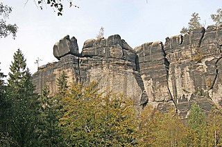
The Schrammsteine are a long, strung-out, very jagged group of rocks in the Elbe Sandstone Mountains located east of Bad Schandau in Saxon Switzerland in East Germany. To the north they are bordered by the Kirnitzsch valley, to the south by the Elbe valley and to the east by the Affensteine rocks. The high point of the chain lies at over 400 m above sea level (HN). The viewing point on the Schrammsteine lies at a height of 417.2 m above HN.

The Barbarine is the best-known, free-standing rock formation in the German part of the Elbe Sandstone Mountains. It is a rock pinnacle, 42.7 metres (140 ft) high, and is the symbol of Saxon Switzerland. It was first climbed on 19 September 1905.

The Pfaffenstein, formerly called the Jungfernstein, is a table hill, 434.6 m (1,426 ft) above sea level, in the Elbe Sandstone Mountains in Saxony. It lies west of the River Elbe near Königstein and is also referred to as "Saxon Switzerland in miniature" on account of its diverse structure.
Saxon Switzerland is the largest and one of the best-known climbing regions in Germany, located in the Free State of Saxony. The region is largely coterminous with the natural region of the same name, Saxon Switzerland, but extends well beyond the territory of the National Park within it. It includes the western part of the Elbe Sandstone Mountains and is the oldest non-Alpine climbing region in Germany. Its history of climbing dates back to the first ascent in modern times of the Falkenstein by Bad Schandau gymnasts in 1864. Currently, there are over 1,100 summits with more than 17,000 climbing routes in the Saxon Switzerland area.
The Frienstein, also called the Vorderes Raubschloss, is a rock formation, about 130 metres high, in Saxon Switzerland. It lies on the northern slopes of the Großer Winterberg in the Affensteine rocks. On the rock there was once a watchtower of the Barony of Wildenstein. Today the Frienstein is a popular climbing peak.

The Teufelsturm is a prominent rock tower and climbing rock formed of Elbe Sandstone, about forty metres high in Saxon Switzerland in East Germany. It is located east of the River Elbe on the upper edge of the valley between Schmilka and Bad Schandau in the Schrammsteinen. The Teufelsturm is also referred to as the "Symbol of Saxon Climbing".
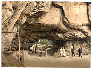
The Kuhstall is the second largest natural arch in the Elbe Sandstone Mountains after the Pravčická brána. It is located on the Neuer Wildenstein, a 337 m high rock outcrop in the hinterland of Saxon Switzerland, south of the Lichtenhain Waterfall and above the Kirnitzsch valley. It is crowned by the 15th-century castle of Wildenstein. The arch is 11 metres high, 17 metres wide and 24 metres deep.

Neurathen Castle, which was first mentioned by this name in 1755, is located near the famous Bastei rocks near Rathen in Saxon Switzerland in the German Free State of Saxony. This was once the largest rock castle in the region, but today only the rooms carved out of the rock, passages, the cistern and rebates for the timber of the former wooden superstructure have survived. In the years 1982–1984 parts of the extensive castle were used to build the open-air museum.

The Großer Bärenstein is a 327 metres high table hill in the German region of Saxon Switzerland in the Free State of Saxony. Close by is the Kleiner Bärenstein which, together with the Großer Bärenstein, forms the massif known as the Bärensteine.

The Großer Widderstein is a mountain, 2,533 m (AA), in the west Austrian state of Vorarlberg. Topographically it belongs to the Allgäu Alps. It is the highest peak in the subgroup of the Southeastern Walsertal Mountains.
Winterstein may refer to:

The Schwedenlöcher is a gorge-like side valley of the Amselgrund near Rathen in Saxon Switzerland.


