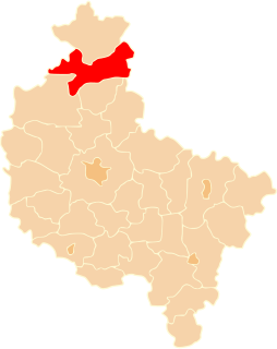
Gmina Kuczbork-Osada is a rural gmina in Żuromin County, Masovian Voivodeship, in east-central Poland. Its seat is the village of Kuczbork-Osada, which lies approximately 9 kilometres north-east of Żuromin and 115 km north-west of Warsaw.

Bolumin is a village in the administrative district of Gmina Dąbrowa Chełmińska, within Bydgoszcz County, Kuyavian-Pomeranian Voivodeship, in north-central Poland. It lies approximately 5 kilometres (3 mi) south of Dąbrowa Chełmińska, 20 km (12 mi) east of Bydgoszcz, and 26 km (16 mi) north-west of Toruń.
Zakrzewska Osada is a village in the administrative district of Gmina Więcbork, within Sępólno County, Kuyavian-Pomeranian Voivodeship, in north-central Poland. It lies approximately 6 kilometres (4 mi) west of Więcbork, 12 km (7 mi) south-west of Sępólno Krajeńskie, and 48 km (30 mi) north-west of Bydgoszcz.
Chylin is a village in the administrative district of Gmina Wierzbica, within Chełm County, Lublin Voivodeship, in eastern Poland. It lies approximately 3 kilometres (2 mi) north of Wierzbica, 19 km (12 mi) north-west of Chełm, and 54 km (34 mi) east of the regional capital Lublin.
Smolniki is a village in the administrative district of Gmina Rutka-Tartak, within Suwałki County, Podlaskie Voivodeship, in north-eastern Poland, close to the border with Lithuania. It lies approximately 12 kilometres (7 mi) south of Wiżajny, 23 km (14 mi) north of Suwałki, and 132 km (82 mi) north of the regional capital Białystok.
Chruścinek is a village in the administrative district of Gmina Łanięta, within Kutno County, Łódź Voivodeship, in central Poland.
Szyjki is a village in the administrative district of Gmina Glinojeck, within Ciechanów County, Masovian Voivodeship, in east-central Poland. It lies approximately 4 kilometres (2 mi) north of Glinojeck, 24 km (15 mi) west of Ciechanów, and 86 km (53 mi) north-west of Warsaw.
Łążek is a village in the administrative district of Gmina Kuczbork-Osada, within Żuromin County, Masovian Voivodeship, in east-central Poland. It lies approximately 9 kilometres (6 mi) north-east of Kuczbork-Osada, 17 km (11 mi) north-east of Żuromin, and 121 km (75 mi) north-west of Warsaw.
Daniel is a part of Pośrednik village in the administrative district of Gmina Szczytniki, within Kalisz County, Greater Poland Voivodeship, in west-central Poland. It lies approximately 19 kilometres (12 mi) south-east of Kalisz and 125 km (78 mi) south-east of the regional capital Poznań.
Nowa Święta-Osada is a settlement in the administrative district of Gmina Złotów, within Złotów County, Greater Poland Voivodeship, in west-central Poland.
Ostrowiec-Osada is a settlement in the administrative district of Gmina Dobiegniew, within Strzelce-Drezdenko County, Lubusz Voivodeship, in western Poland.
Iłowo-Osadapronounced [iˈwɔvɔ - ɔˈsada] is a village in Działdowo County, Warmian-Masurian Voivodeship, in northern Poland. It is the seat of the gmina called Gmina Iłowo-Osada. It lies approximately 11 kilometres (7 mi) south-east of Działdowo and 70 km (43 mi) south of the regional capital Olsztyn.
Iłowo-Wieś is a village in the administrative district of Gmina Iłowo-Osada, within Działdowo County, Warmian-Masurian Voivodeship, in northern Poland. It lies approximately 2 kilometres (1 mi) north of Iłowo-Osada, 10 km (6 mi) south-east of Działdowo, and 69 km (43 mi) south of the regional capital Olsztyn.
Krajewo is a village in the administrative district of Gmina Iłowo-Osada, within Działdowo County, Warmian-Masurian Voivodeship, in northern Poland. It lies approximately 7 kilometres (4 mi) east of Iłowo-Osada, 17 km (11 mi) south-east of Działdowo, and 71 km (44 mi) south of the regional capital Olsztyn.
Staświny-Osada is a settlement in the administrative district of Gmina Miłki, within Giżycko County, Warmian-Masurian Voivodeship, in northern Poland.
Grabowo-Osada is a settlement in the administrative district of Gmina Lubawa, within Iława County, Warmian-Masurian Voivodeship, in northern Poland.
Krajewo-Kawęczyno is a settlement in the administrative district of Gmina Janowiec Kościelny, within Nidzica County, Warmian-Masurian Voivodeship, in northern Poland.
Mikosze-Osada is a settlement in the administrative district of Gmina Orzysz, within Pisz County, Warmian-Masurian Voivodeship, in northern Poland.
Skowrony is a village in the administrative district of Gmina Gryfice, within Gryfice County, West Pomeranian Voivodeship, in north-western Poland. It lies approximately 6 kilometres (4 mi) east of Gryfice and 72 km (45 mi) north-east of the regional capital Szczecin.
Radzim is a village in the administrative district of Gmina Radowo Małe, within Łobez County, West Pomeranian Voivodeship, in north-western Poland. It lies approximately 11 kilometres (7 mi) west of Radowo Małe, 22 km (14 mi) west of Łobez, and 55 km (34 mi) north-east of the regional capital Szczecin.