Mickledore is a narrow ridge, 840 metres (2755 ft) high, connecting the mountains of Sca Fell and Scafell Pike in the English Lake District. It is also a pass between the valleys of Wasdale and Eskdale.

Bowfell is a pyramid-shaped mountain lying at the heart of the English Lake District, in the Southern Fells area. It is the sixth-highest mountain in the Lake District and one of the most popular of the Lake District fells for walkers. It is listed in Alfred Wainwright's 'best half dozen' Lake District fells.
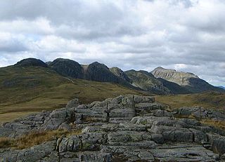
Crinkle Crags is a fell in the English Lake District in the county of Cumbria. It forms part of two major rings of mountains, surrounding the valleys of Great Langdale and Upper Eskdale. The name reflects the fell's physical appearance as its summit ridge is a series of five rises and depressions (crinkles) that are very distinctive from the valley floor. In Old English, cringol means twisted or wrinkled.
Hard Knott is a fell in the English Lake District, at the head of Eskdale.

Harter Fell is a mountain in the western part of the English Lake District, located between the Eskdale and Duddon valleys. Its height is 649 m (2128 ft). There are several walking routes to the summit.

The Duddon Valley is a valley in the Lake District National Park in Cumbria, England. The River Duddon flows through the valley, rising in the mountains between Eskdale and Langdale, before flowing into the Irish Sea near Broughton in Furness. In its lower reaches it is bounded by the Furness Fells and Harter Fell.

Great Langdale is a valley in the Lake District National Park in North West England, the epithet Great distinguishing it from the neighbouring valley of Little Langdale.
Fairfield Horseshoe is a classic circular hillwalking ridge walk route starting from Rydal or Ambleside in the English Lake District that takes in all the fells that surround the valley of the Rydal Beck.

Esk Hause is a mountain pass in the English Lake District, England. It is where the paths from Eskdale, Borrowdale, Langdale and Wasdale all meet. Esk Hause is a first step to reaching higher summits, such as Scafell Pike, Great End, Esk Pike and Allen Crags, which are all nearby. This can be a confusing place for walkers, especially in mist. This is because two paths cross at right angles on a tilted grass plateau, but not at the summit of the plateau. The popular Great Langdale-Wasdale path crosses at the height of 2386ft at the wall shelter; this is the lower of the two passes known as Esk Hause, but is, in fact, not the true pass, which is 100ft higher and 300 yards distant, a less-used pass between Eskdale and Borrowdale that occupies the depression between Great End (2984ft) and Esk Pike (2903ft). The 'true' Esk Hause is the highest pass in the Lake District, but Sticks Pass is commonly named as Lakeland's highest pass, most probably because fellwalkers equate 'Esk Hause' with the lower of the two passes.

Helm Crag is a fell in the English Lake District situated in the Central Fells to the north of Grasmere. Despite its low height it sits prominently at the end of a ridge, easily seen from the village. This, combined with the distinctive summit rocks which provide the alternative name 'The Lion and the Lamb', makes it one of the most recognised hills in the District.

Boot is a small village in Eskdale, Cumbria, in the Lake District of England. It forms part of the Borough of Copeland.

The Southern Fells are a group of hills in the English Lake District. Including Scafell Pike, the highest peak in England, they occupy a broad area to the south of Great Langdale, Borrowdale and Wasdale. High and rocky towards the centre of the Lake District, the Southern Fells progressively take on a moorland character toward the south west. In the south east are the well known Furness Fells, their heavily quarried flanks rising above Coniston Water.

The Bannisdale Horseshoe is an upland area near the eastern boundary of the Lake District National Park, surrounding the valley of Bannisdale Beck, a tributary of the River Mint. It is described in the final chapter of Wainwright's book The Outlying Fells of Lakeland. It describes

Hesk Fell is a hill in the south-west of the English Lake District, between the Duddon Valley and Eskdale near Ulpha, Cumbria. It is the subject of a chapter of Wainwright's book The Outlying Fells of Lakeland. It reaches 1,566 feet (477 m) and Wainwright's route, an anticlockwise circuit from the Birker Fell road, also visits The Pike at 1,214 feet (370 m). Wainwright admits that the fell "has many shortcomings" and that the view of Scafell Pike and its neighbours is "the only reward for the ascent".

The Naddle Horseshoe is a group of summits in the English Lake District, south of Mardale valley, Cumbria. It is the subject of a chapter of Wainwright's book The Outlying Fells of Lakeland.

Great Worm Crag is a hill in south west of the English Lake District, north of Ulpha, Cumbria. It is the subject of a chapter of Wainwright's book The Outlying Fells of Lakeland. It reaches 1,400 feet (430 m) and Wainwright's route is a clockwise circuit from the fell road between Ulpha and Eskdale Green.

Irton Pike is a hill in the west of the English Lake District, near Santon Bridge, Cumbria. It is the subject of a chapter of Wainwright's book The Outlying Fells of Lakeland. It reaches 751 feet (229 m) and Wainwright's walk is an anticlockwise circuit from Irton Road station on the Ravenglass and Eskdale Railway, near Eskdale Green. He describes "this tiny top" as "a near-perfect solace for reminscences of past happy days on the higher fells", adding "Climb Irton Pike while ye may!"