
Wrightwood is a census-designated place in San Bernardino County, California. It sits at an elevation of 5,935 feet (1,809 m). The population was 4,525 at the 2010 census, up from the population of 3,837 at the 2000 census. Wrightwood is located 77 miles northeast of Los Angeles.

Lincoln Park is a designated community area on the North Side of Chicago, Illinois. Lying to the west of Lincoln Park, Chicago's largest park, it is one of the most affluent neighborhoods in Chicago.

The Angeles National Forest (ANF) of the U.S. Forest Service is located in the San Gabriel Mountains and Sierra Pelona Mountains, primarily within Los Angeles County in southern California. The ANF manages a majority of the San Gabriel Mountains National Monument.

Logan Square is an official community area, historical neighborhood, and public square located on the northwest side of the City of Chicago. The Logan Square community area is one of the 77 city-designated community areas established for planning purposes. The Logan Square neighborhood, located within the Logan Square community area, is centered on the public square that serves as its namesake, located at the three-way intersection of Milwaukee Avenue, Logan Boulevard and Kedzie Boulevard.
Ashburn, one of Chicago's 77 community areas, is located on the southwest side of the city. Greater Ashburn covers nearly five square miles. The approximate boundaries of Ashburn are 75th Street (N), Western Avenue (E), 87th Street (S) and Cicero Avenue (W).

The Angeles Crest Highway is a two-lane highway over the San Gabriel Mountains, in Los Angeles County, California. Its route is to/through the San Gabriel Mountains National Monument and the Angeles National Forest. With the exception of a 1,000 feet (300 m)-long section in La Cañada Flintridge, the entire route is part of California State Route 2.

Harry and the Hendersons is a 1987 American fantasy comedy film directed and produced by William Dear and starring John Lithgow, Melinda Dillon, Don Ameche, David Suchet, Margaret Langrick, Joshua Rudoy, Lainie Kazan, and Kevin Peter Hall. Steven Spielberg served as its uncredited executive producer, while Rick Baker provided the makeup and the creature designs for Harry. It is the story of a Seattle family's encounter with the cryptozoological creature Bigfoot, partially inspired by the numerous claims of sightings in the Pacific Northwest, California, and other parts of both the United States and Canada since the late 1960s. The film won an Oscar for Best Makeup, and inspired a follow-up TV series of the same name. In the United Kingdom, the film was originally released as Bigfoot and the Hendersons, though the TV series retained the American title. The DVD and all current showings of the movie in the UK now refer to the movie by its original title.
The Chicago Gaylords, also known as the Almighty Gaylords, is a Chicago street gang which was most active during the mid and late 20th century. It originated in the neighborhood of Grand and Noble. The original president of the Gaylords selected the name after reading about the Gaylords in the public library. They were a part of the People Nation alliance.

The Harquahala Mountains are the highest mountain range in southwestern Arizona, United States and are located southwest of the towns of Aguila and Wenden. The name originated from the Yavapai 'ʼHakhe:la", which means "running water". The range is oriented from northeast to southwest and is approximately 32 km long and 20 km at its widest point. At the northeast are two prominent peaks, Eagle Eye Peak and Eagle Eye Mountain. One has a natural opening or bridge through it appearing as an eye high up, and is the namesake for the peaks and Aguila. The highest point, Harquahala Peak, rises to 5,681 ft. Socorro Peak, 3270 ft, is at the southwest end of the range.
Big Pines is an unincorporated community in Los Angeles County, California, United States. It is in the Angeles National Forest, San Gabriel Mountains.

Lincoln Avenue is a street of the north side of city of Chicago. It runs from Clark Street on the western border of Lincoln Park largely to the northwest, ending in Morton Grove, Illinois. It leaves the city limits of Chicago at Devon Avenue, through the village of Lincolnwood, curves through the village of Skokie and ends at Dempster Street in Morton Grove. In total distance it is about 13 miles (21 km) long, although it is not completely continuous. Between Foster Avenue and Skokie Boulevard U.S. Route 41 runs on Lincoln Avenue.
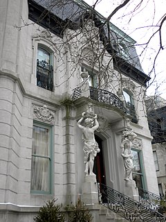
The Francis J. Dewes House is a house located at 503 West Wrightwood Avenue in Chicago, Illinois, United States. The house was built in 1896 by Adolph Cudell and Arthur Hercz for brewer Francis J. Dewes. It was designated a Chicago Landmark on June 12, 1974. It was added to the National Register of Historic Places on August 14, 1973
The Clinton B. Ford Observatory (Wrightwood) is an astronomical observatory that is associated historically with the American Association of Variable Star Observers (AAVSO). The observatory is located near the border of the Angeles National Forest and the San Bernardino National Forest near Wrightwood, California. It was founded by the late astronomer Clinton B. Ford.

Kelvyn Park is located at 4438 W. Wrightwood Avenue in the Hermosa neighborhood of North Side, Chicago, Illinois. It is part of the Chicago Park District.

Wiggly Field is a dog park on the north side of Chicago, Illinois. It was established in 1997 and was Chicago's "first official dog exercise and play area". The informal name Wiggly Field is a play on words for the nearby historic baseball stadium, Wrigley Field.
Chicago International Charter School (CICS) is a charter school with 14 campuses in Chicago, Illinois. CICS has a student population composed of 96% ethnic minorities. Of the population, 66% are African American, 25% are Hispanic, 4% are Caucasian, 2% are Asian/Pacific Islander and 1% are multi-racial, with 86% coming from low income households.
Francis Joseph Dewes (1845–1922) was a Chicago brewer and millionaire. Born in Losheim, near Trier in Prussia, he was the son of Peter Dewes, a brewer and member of the German parliament. Francis Dewes emigrated to the United States of America in 1868 and settled in Chicago. There he found employment as a bookkeeper for established brewing companies such as Rehm and Bartholomae and the Busch and Brand Brewing Company. After rising through the ranks, he founded his own successful brewing firm in 1882.

The Snowline Joint Unified School District (SJUSD) is the school district for part of the Victor Valley in the Mojave Desert and northeastern San Gabriel Mountains, located within San Bernardino County, California.

