Rymanów-Zdrój is a village and a spa in southern Poland, in Subcarpathian Voivodeship, in Krosno County.

Sulistrowa is a village in the administrative district of Gmina Chorkówka, within Krosno County, Subcarpathian Voivodeship, in south-eastern Poland. It lies approximately 7 kilometres (4 mi) south-west of Chorkówka, 13 km (8 mi) south-west of Krosno, and 55 km (34 mi) south-west of the regional capital Rzeszów.
Podniebyle is a village in the administrative district of Gmina Jedlicze, within Krosno County, Subcarpathian Voivodeship, in south-eastern Poland. It lies approximately 5 kilometres (3 mi) south-west of Jedlicze, 10 km (6 mi) west of Krosno, and 48 km (30 mi) south-west of the regional capital Rzeszów.
Niżna Łąka is a village in the administrative district of Gmina Miejsce Piastowe, within Krosno County, Subcarpathian Voivodeship, in south-eastern Poland. It lies approximately 8 kilometres (5 mi) south of Krosno and 51 km (32 mi) south-west of the regional capital Rzeszów.

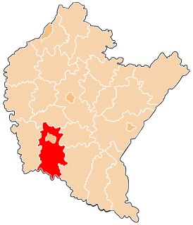
Bałucianka is a village in the administrative district of Gmina Rymanów, within Krosno County, Subcarpathian Voivodeship, in south-eastern Poland. It lies approximately 8 kilometres (5 mi) south-west of Rymanów, 18 km (11 mi) south of Krosno, and 58 km (36 mi) south of the regional capital Rzeszów.
Bzianka is a village in the administrative district of Gmina Rymanów, within Krosno County, Subcarpathian Voivodeship, in south-eastern Poland. It lies approximately 9 kilometres (6 mi) north-east of Rymanów, 15 km (9 mi) south-east of Krosno, and 45 km (28 mi) south of the regional capital Rzeszów.

Głębokie is a village in the administrative district of Gmina Rymanów, within Krosno County, Subcarpathian Voivodeship, in south-eastern Poland. It lies approximately 4 kilometres (2 mi) south-east of Rymanów, 20 km (12 mi) south-east of Krosno, and 55 km (34 mi) south of the regional capital Rzeszów.

Klimkówka is a village in the administrative district of Gmina Rymanów, within Krosno County, Subcarpathian Voivodeship, in south-eastern Poland. It lies approximately 5 kilometres (3 mi) north-west of Rymanów, 13 km (8 mi) south-east of Krosno, and 52 km (32 mi) south of the regional capital Rzeszów.

Królik Polski is a village in the administrative district of Gmina Rymanów, within Krosno County, Subcarpathian Voivodeship, in south-eastern Poland. It lies approximately 8 kilometres (5 mi) south-west of Rymanów, 20 km (12 mi) south of Krosno, and 59 km (37 mi) south of the regional capital Rzeszów.
Ladzin is a village in the administrative district of Gmina Rymanów, within Krosno County, Subcarpathian Voivodeship, in south-eastern Poland. It lies approximately 5 kilometres (3 mi) north of Rymanów, 13 km (8 mi) south-east of Krosno, and 49 km (30 mi) south of the regional capital Rzeszów.
Łazy is a village in the administrative district of Gmina Rymanów, within Krosno County, Subcarpathian Voivodeship, in south-eastern Poland. It lies approximately 3 kilometres (2 mi) north-east of Rymanów, 16 km (10 mi) south-east of Krosno, and 51 km (32 mi) south of the regional capital Rzeszów.

Milcza is a village in the administrative district of Gmina Rymanów, within Krosno County, Subcarpathian Voivodeship, in south-eastern Poland. It lies approximately 7 kilometres (4 mi) north-east of Rymanów, 15 km (9 mi) south-east of Krosno, and 47 km (29 mi) south of the regional capital Rzeszów.
Posada Górna is a village in the administrative district of Gmina Rymanów, within Krosno County, Subcarpathian Voivodeship, in south-eastern Poland. It lies approximately 2 kilometres (1 mi) west of Rymanów, 16 km (10 mi) south-east of Krosno, and 53 km (33 mi) south of the regional capital Rzeszów.

Rudawka Rymanowska is a village in the administrative district of Gmina Rymanów, within Krosno County, Subcarpathian Voivodeship, in south-eastern Poland. It lies approximately 7 kilometres (4 mi) south-east of Rymanów, 23 km (14 mi) south-east of Krosno, and 58 km (36 mi) south of the regional capital Rzeszów.

Sieniawa is a village in the administrative district of Gmina Rymanów, within Krosno County, Podkarpackie Province, in south-eastern Poland. It lies approximately 4 kilometres (2 mi) south-east of Rymanów, 20 km (12 mi) south-east of Krosno, and 54 km (34 mi) south of the regional capital Rzeszów.
Wisłoczek is a village in the administrative district of Gmina Rymanów, within Krosno County, Subcarpathian Voivodeship, in south-eastern Poland. It lies approximately 6 km (4 mi) south of Rymanów, 21 km (13 mi) south-east of Krosno, and 59 km (37 mi) south of the regional capital Rzeszów.
Wróblik Królewski is a village in the administrative district of Gmina Rymanów, within Krosno County, Subcarpathian Voivodeship, in south-eastern Poland. It lies approximately 6 kilometres (4 mi) north of Rymanów, 12 km (7 mi) south-east of Krosno, and 48 km (30 mi) south of the regional capital Rzeszów.
Pstrągówka is a village in the administrative district of Gmina Wiśniowa, within Strzyżów County, Subcarpathian Voivodeship, in south-eastern Poland. It lies approximately 12 kilometres (7 mi) west of Strzyżów and 33 km (21 mi) south-west of the regional capital Rzeszów.
Chociejów is a village in the administrative district of Gmina Gubin, within Krosno Odrzańskie County, Lubusz Voivodeship, in western Poland, close to the German border. It lies approximately 10 kilometres (6 mi) south-east of Gubin, 27 km (17 mi) south-west of Krosno Odrzańskie, and 49 km (30 mi) west of Zielona Góra.
Strzegów is a village in the administrative district of Gmina Gubin, within Krosno Odrzańskie County, Lubusz Voivodeship, in western Poland, close to the German border. It lies approximately 17 kilometres (11 mi) south-west of Gubin, 41 km (25 mi) south-west of Krosno Odrzańskie, and 63 km (39 mi) west of Zielona Góra.