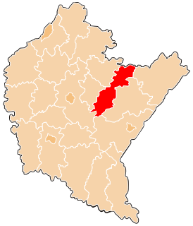
Przeworsk County is a unit of territorial administration and local government (powiat) in Subcarpathian Voivodeship, south-eastern Poland. It came into being on January 1, 1999, as a result of the Polish local government reforms passed in 1998. Its administrative seat and largest town is Przeworsk, which lies 36 kilometres (22 mi) east of the regional capital Rzeszów. The county also contains the towns of Kańczuga, lying 11 km (7 mi) south-west of Przeworsk, and Sieniawa, 15 km (9 mi) north-east of Przeworsk.
Gmina Adamówka is a rural gmina in Przeworsk County, Subcarpathian Voivodeship, in south-eastern Poland. Its seat is the village of Adamówka, which lies approximately 26 kilometres (16 mi) north-east of Przeworsk and 56 km (35 mi) north-east of the regional capital Rzeszów.
Gmina Tryńcza is a rural gmina in Przeworsk County, Subcarpathian Voivodeship, in south-eastern Poland. Its seat is the village of Tryńcza, which lies approximately 13 kilometres (8 mi) north-east of Przeworsk and 43 km (27 mi) east of the regional capital Rzeszów.

Dobcza is a village in the administrative district of Gmina Adamówka, within Przeworsk County, Subcarpathian Voivodeship, in south-eastern Poland. It lies approximately 5 kilometres (3 mi) south-east of Adamówka, 26 km (16 mi) north-east of Przeworsk, and 58 km (36 mi) north-east of the regional capital Rzeszów.
Krasne is a village in the administrative district of Gmina Adamówka, within Przeworsk County, Subcarpathian Voivodeship, in south-eastern Poland. It lies approximately 3 kilometres (2 mi) east of Adamówka, 27 km (17 mi) north-east of Przeworsk, and 58 km (36 mi) north-east of the regional capital Rzeszów.
Majdan Sieniawski is a village in the administrative district of Gmina Adamówka, within Przeworsk County, Subcarpathian Voivodeship, in south-eastern Poland. It lies approximately 4 kilometres (2 mi) north-east of Adamówka, 29 km (18 mi) north-east of Przeworsk, and 58 km (36 mi) north-east of the regional capital Rzeszów.
Szegdy is a village in the administrative district of Gmina Adamówka, within Przeworsk County, Subcarpathian Voivodeship, in south-eastern Poland. It lies approximately 4 kilometres (2 mi) north-east of Adamówka, 29 km (18 mi) north-east of Przeworsk, and 58 km (36 mi) north-east of the regional capital Rzeszów.
Gorzyce is a village in the administrative district of Gmina Tryńcza, within Przeworsk County, Subcarpathian Voivodeship, in south-eastern Poland. It lies approximately 5 kilometres (3 mi) south of Tryńcza, 9 km (6 mi) north-east of Przeworsk, and 43 km (27 mi) east of the regional capital Rzeszów.
Jagiełła is a village in the administrative district of Gmina Tryńcza, within Przeworsk County, Subcarpathian Voivodeship, in south-eastern Poland. It lies approximately 8 kilometres (5 mi) south of Tryńcza, 7 km (4 mi) north-east of Przeworsk, and 41 km (25 mi) east of the regional capital Rzeszów.
Wólka Ogryzkowa is a village in the administrative district of Gmina Tryńcza, within Przeworsk County, Subcarpathian Voivodeship, in south-eastern Poland. It lies approximately 4 kilometres (2 mi) south of Tryńcza, 9 km (6 mi) north-east of Przeworsk, and 42 km (26 mi) east of the regional capital Rzeszów.
Łapajówka is a village in the administrative district of Gmina Zarzecze, within Przeworsk County, Subcarpathian Voivodeship, in south-eastern Poland. It lies approximately 3 kilometres (2 mi) north-west of Zarzecze, 8 km (5 mi) south of Przeworsk, and 37 km (23 mi) east of the regional capital Rzeszów.
Gorliczyna is a village in the administrative district of Gmina Przeworsk, within Przeworsk County, Subcarpathian Voivodeship, in south-eastern Poland. It lies approximately 3 kilometres (2 mi) north-west of Przeworsk and 35 km (22 mi) east of the regional capital Rzeszów.
Rozbórz is a village in the administrative district of Gmina Przeworsk, within Przeworsk County, Subcarpathian Voivodeship, in south-eastern Poland. It lies approximately 5 kilometres (3 mi) south-east of Przeworsk and 40 km (25 mi) east of the regional capital Rzeszów.
Czerce is a village in the administrative district of Gmina Sieniawa, within Przeworsk County, Subcarpathian Voivodeship, in south-eastern Poland. It lies approximately 6 kilometres (4 mi) south-east of Sieniawa, 16 km (10 mi) north-east of Przeworsk, and 50 km (31 mi) east of the regional capital Rzeszów.
Czerwona Wola is a village in the administrative district of Gmina Sieniawa, within Przeworsk County, Subcarpathian Voivodeship, in south-eastern Poland. It lies approximately 9 kilometres (6 mi) east of Sieniawa, 19 km (12 mi) north-east of Przeworsk, and 53 km (33 mi) east of the regional capital Rzeszów.
Dybków is a village in the administrative district of Gmina Sieniawa, within Przeworsk County, Subcarpathian Voivodeship, in south-eastern Poland. It lies approximately 2 kilometres (1 mi) south of Sieniawa, 14 km (9 mi) north-east of Przeworsk, and 47 km (29 mi) east of the regional capital Rzeszów.
Leżachów is a village in the administrative district of Gmina Sieniawa, within Przeworsk County, Subcarpathian Voivodeship, in south-eastern Poland. It lies approximately 4 kilometres (2 mi) south of Sieniawa, 13 km (8 mi) north-east of Przeworsk, and 46 km (29 mi) east of the regional capital Rzeszów.
Pigany is a village in the administrative district of Gmina Sieniawa, within Przeworsk County, Subcarpathian Voivodeship, in south-eastern Poland. It lies approximately 4 kilometres (2 mi) north-west of Sieniawa, 16 km (10 mi) north of Przeworsk, and 46 km (29 mi) north-east of the regional capital Rzeszów.
Rudka is a village in the administrative district of Gmina Sieniawa, within Przeworsk County, Subcarpathian Voivodeship, in south-eastern Poland. It lies approximately 6 kilometres (4 mi) north of Sieniawa, 20 km (12 mi) north-east of Przeworsk, and 50 km (31 mi) north-east of the regional capital Rzeszów.


