Xikang

Last updated

Xikang Province
西康省
Flag of the Republic of China.svg Province of the Republic of China (1939–1950)
1939–1950
ROC Div Xikang.svg
Xikang Province in the Republic of China
Capital Kangding (1912–1931)
Ba'an (1931–1935)
Ya'an (1935–1936)
Kangding (1935–1949)
Xichang (1949–1950)
Area 
 Estimate
451,521 km2 (174,333 sq mi)
Population 
 Estimate
1,748,458
Historical era20th century
 Established
1939
 Fall of Xichang
27 March 1950
 Disestablished
1950
Preceded by
Succeeded by
Flag of the Republic of China (1912-1928).svg Chuanbian Special Region
Xikang Flag of China.svg
Chamdo Region Flag of China.svg
Today part of China
India
Xikang Province
西康省
Flag of the People's Republic of China.svg Province of the People's Republic of China (1950–1955)
1950–1955
PRC-Xikang.png
Xikang Province (orange) in the People's Republic of China
Capital Kangding (1950–1951)
Ya'an (1951–1955)
Area 
 1953
451,521 km2 (174,333 sq mi)
Population 
 1953
3,381,064
Historical era20th century
 Established
1950
 Disestablished
1955
Preceded by
Succeeded by
Flag of the Republic of China.svg Xikang
Sichuan Flag of China.svg
Tibet Autonomous Region Flag of China.svg
Today part of China
India

Xikang (also Sikang or Hsikang) was a nominal province [1] formed by the Republic of China in 1939 on the initiative of prominent Sichuan warlord Liu Wenhui [2] and retained by the early People's Republic of China. The former territory of Xikang is now divided between the Tibet Autonomous Region and Sichuan province.

Contents

The idea behind Xikang province was to form a single unified province for the entire Kham region under direct Chinese administration, in effect annexing the western Kham region that was then under Tibetan control. Kham was entirely populated by Tibetan people called Khampas. The then-independent Tibet controlled the portion of Kham west of the Upper Yangtze River. [3] The nominal Xikang province also included in the south the Assam Himalayan region (Arunachal Pradesh) that Tibet had recognised as a part of British India by the 1914 McMahon Line agreement. [4] The eastern part of the province was inhabited by a number of different ethnic groups, such as Han Chinese, Yi, Qiang people and Tibetan, then known as Chuanbian (川邊), a special administrative region of the Republic of China. In 1939, it became the new Xikang province with the additional territories belonging to Tibetan and British control added in. After the People's Republic of China invaded and occupied Tibet, the earlier nationalist imagination of Xikang came to fruition.

The provincial capital of Xikang was Kangding from 1939 to 1951 and Ya'an from 1951 to 1955. The province had a population of 3.4 million in 1954. [5]

History

The Xikang province sketched on a 1950 map by the CIA. Provincial borders are dark green lines. Xikang province in 1950 CIA map of Tibet.jpg
The Xikang province sketched on a 1950 map by the CIA. Provincial borders are dark green lines.
The Chinese control of southeastern Tibet shown along with the proposed Simla Convention frontier of 1914. 1945 Central and Eastern Tibet from Tibetan Precis by Richardson in Himalayan Triangle.jpg
The Chinese control of southeastern Tibet shown along with the proposed Simla Convention frontier of 1914.

In 1910, general Zhao Erfeng occupied Kham region, destroyed a few monasteries and killed over 1000 lamas. Later on, he proclaimed this territory as a new Chinese province subsequently known as Xikang.

Following the Wuchang Uprising in October 1911, which led to the downfall of the Qing dynasty, the region[ which? ] was established as the Chuanbian Special Administrative District (川邊特別行政區) by the newly founded Republic of China.

In June 1930, eastern Kham (later Xikang) was invaded by the army of Tibet, precipitating the Sino-Tibetan War. With the district locked in internal struggles, no reinforcements were sent to support the Sichuanese troops stationed here. As a result, the Tibetan army captured Garzê and Xinlong Counties without encountering much resistance. When a negotiated ceasefire failed, Tibetan forces expanded the war, attempting to capture parts of southern Qinghai province. In March 1932, their force invaded Qinghai but was defeated by the local Hui warlord Ma Bufang in July, who routed the Tibetan army and drove it back to this district.[ which? ]

The Hui army captured counties that had fallen into the hands of the Tibetan army since 1919. Their victories threatened the supply lines of the Tibetan forces in Garzê and Xinlong. As a result, part of the Tibetan army was forced to withdraw.

In 1932 Liu Wenhui in cooperation with the Qinghai army, sent out a brigade to attack the Tibetan troops in Garzê and Xinlong, eventually occupying them, Dêgê and other counties east of the Jinshajiang River. The 1934 Khamba Rebellion led by the Pandatsang family broke out against the Tibetan government in Lhasa. The Khampa revolutionary leader Pandatsang Rapga was involved.

In January 1939, the Chuanbian Special Administrative District officially became a province of the Republic, the Hsikang Province. Kesang Tsering was sent by the Chinese to Batang to take control of Sikang, where he formed a local government. He was sent there for the purpose of propagating the Three Principles of the People to the Khampa. [6]

In 1950, following the defeat of the Kuomintang by the Chinese Communist Party in the Chinese Civil War, Xikang was split along the Yangtze into Sikang to the east and a separate Chamdo Territory (昌都地区) to the west. Chamdo was merged into Tibet Autonomous Region in 1965. The rest of Hsikang was merged into Sichuan in 1955.

Administrative divisions

1939–1950

NameAdministrative SeatTraditional ChineseSubdivisionsComments
First Administrative CircuitKangding County第一行政督察區4 counties, 1 bureauLater the Xikang Province Tibetan Autonomous Region
Second Administrative CircuitYingjing County第二行政督察區7 countiesLater the Ya'an Division
Third Administrative CircuitXichang County第三行政督察區9 counties, 3 bureausLater the XIchang Division
Fourth Administrative CircuitGarzê County第四行政督察區15 countiesLater the Xikang Province Tibetan Autonomous Region
Fifth Administrative Circuit第五行政督察區13 countiesChamdo Region; de facto controlled by Tibet

1950–1955

NameSimplified ChineseHanyu PinyinSubdivisions
Ya'an (1951–1955)雅安市Yǎ'ān shì1 city
Ya'an
Ya'an Division雅安专区Yǎ'ān Zhuānqū8 counties
Ya'an (1950–1951), Baoxing, Lushan, Tianquan, Yingjing, Hanyuan, Mingshan (1951–1955), Shimian (1951–1955)
Xichang Division西昌专区Xīchāng Zhuānqū13 counties
Xichang , Yanyuan, Yanbian, Huili, Ningnan, Dechang, Zhaojue (1950–1952), Yuexi, Mianning, Jinkang (1952–1955), Muli (1952–1955), Miyi (1952–1955), Huidong
3 bureaus
Puge (1950–1952), Ningdong (1950–1952), Luoning (1950–1952)
Xikang Province Tibetan Autonomous Region西康省藏族自治区Xīkāng Shěng Zàngzú Zìzhìqū20 counties
direct controlled
Kangding , Danba, Qianning, Yajiang, Luding, Jiulong
1 bureau
Jintang

Ganzi Regional Office (1951–1955)
Ganzi, Shiqi, Dengke, Dege, Baiyu, Zhanghua→Xinlong, Luhuo, Daofu


Litang Regional Office (1951–1955)
Litang, Batang, Derong, Dingxiang→Xiangcheng, Daocheng, Yidun

Liangshan Yi Autonomous Region (1952–1955)凉山彝族自治区Liángshān Yízú Zìzhìqū8 counties
Zhaojue, Puge, Ningdong, Xide, Butuo, Jinyang, Meigu, Puxiong

List of governors

   Kuomintang (Nationalist)   Chinese Communist Party

Chairperson of the Provincial Government

No.PortraitName
(Birth–Death)
Term of officePolitical party
1 Liu Wenhui.jpg Liu Wenhui
劉文輝
Liú Wénhuī
(1895–1976)
1 January 19399 December 1949 Kuomintang
Defected to the Communists.
2 He Guoguang.jpg Ho Kuo-kuang
賀國光
Hè Guóguāng
(1885–1969)
25 December 1949March 1950 Kuomintang
Fled to Taiwan via Haikou after fall of Xichang.

Xikang CPC Party Committee Secretary

No.PortraitName
(Birth–Death)
Term of officePolitical party
1Liao Zhigao
廖志高
Liào Zhìgāo
(1913–2000)
19501955 Chinese Communist Party
Province abolished.

Xikang People's Government Chairperson (Governor after January 1955)

No.PortraitName
(Birth–Death)
Term of officePolitical party
1Liao Zhigao
廖志高
Liào Zhìgāo
(1913–2000)
26 April 1950September 1955 Chinese Communist Party
Province abolished.

See also

Related Research Articles

<span class="mw-page-title-main">Amdo</span> Traditional region of Tibet

Amdo is one of the three traditional Tibetan regions, the others being U-Tsang in the west and Kham in the east. Ngari in the north-west was incorporated into Ü-Tsang. Amdo is also the birthplace of the 14th Dalai Lama. Amdo encompasses a large area from the Machu to the Drichu (Yangtze). Amdo is mostly coterminous with China's present-day Qinghai province, but also includes small portions of Sichuan and Gansu provinces.

<span class="mw-page-title-main">Kham</span> Traditional region of Tibet

Kham is one of the three traditional Tibetan regions, the others being Amdo in the northeast, and Ü-Tsang in central Tibet. The original residents of Kham are called Khampas, and were governed locally by chieftains and monasteries. Kham presently covers a land area distributed between five regions in China, most of it in Tibet Autonomous Region and Sichuan, with smaller portions located within Qinghai, Gansu and Yunnan provinces.

<span class="mw-page-title-main">Yalong River</span> River in China

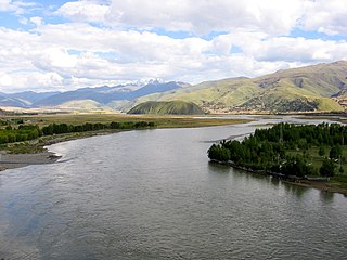
The Yalong River, or Nyag Chu, is a major tributary river of the Yangtze River in Southwest China. With a length of 1,571 km (976 mi), the Yalong River flows from north to south through the Hengduan Mountains in western Sichuan Province.

<span class="mw-page-title-main">Garzê Tibetan Autonomous Prefecture</span> Autonomous prefecture in Sichuan, China

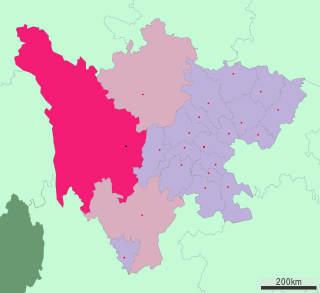
Garzê Tibetan Autonomous Prefecture, often shortened to Ganzi Prefecture, is an autonomous prefecture in the western arm of Sichuan province, China bordering Yunnan to the south, the Tibet Autonomous Region to the west, and Gansu to the north and northwest.

<span class="mw-page-title-main">Liu Wenhui</span> Chinese warlord

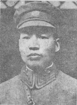
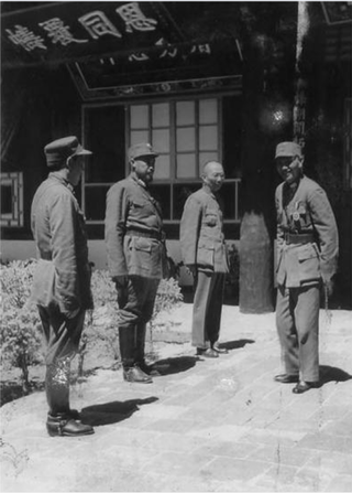
Liu Wenhui was a Chinese general and warlord of Sichuan province. At the beginning of his career, he was aligned with the Kuomintang (KMT), commanding the Sichuan-Xikang Defence Force from 1927 to 1929. The western part of Sichuan province was then known as Xikang. Bordering Tibet, the region had a mixed population of Tibetans and Han Chinese.

This is a list of topics related to Tibet.

<span class="mw-page-title-main">1959 Tibetan uprising</span> Uprising in Lhasa, Tibet, against the Peoples Republic of China

The 1959 Tibetan uprising began on 10 March 1959, when a revolt erupted in Lhasa, the capital of Tibet, which had been under the effective control of the People's Republic of China (PRC) since the Seventeen Point Agreement was reached in 1951. The initial uprising occurred amid general Chinese-Tibetan tensions and a context of confusion, because Tibetan protesters feared that the Chinese government might arrest the 14th Dalai Lama. The protests were also fueled by anti-Chinese sentiment and separatism. At first, the uprising mostly consisted of peaceful protests, but clashes quickly erupted and the Chinese People's Liberation Army (PLA) eventually used force to quell the protests, some of the protesters had captured arms. The last stages of the uprising included heavy fighting, with high civilian and military losses. The 14th Dalai Lama escaped from Lhasa, while the city was fully retaken by Chinese security forces on 23 March 1959. Thousands of Tibetans were killed during the 1959 uprising, but the exact number of deaths is disputed.

<span class="mw-page-title-main">Batang County</span> County in Sichuan, China

Batang County is a county located in western Garzê Tibetan Autonomous Prefecture, Sichuan Province, China. The main administrative centre is known as Batang Town.

<span class="mw-page-title-main">Garzê County</span> County in Sichuan, China

Garzê County or Ganzi County is one of the 18 subdivisions of the Garzê Tibetan Autonomous Prefecture, in northwestern Sichuan province, China. The Yalong River passes just south of the town Garzê, also known as Ganzi, the capital town of the county, which has some 16,920 inhabitants (2010), many of them ethnic Tibetans, and is famous for its Tibetan lamasery. Historically, it is part of the Tibetan cultural region of Kham and now defunct province of Xikang. It lies on the northern section of the Sichuan-Tibet Highway.

<span class="mw-page-title-main">Tibet (1912–1951)</span> Former de facto state in East Asia

Tibet was a de facto independent state in East Asia that lasted from the collapse of the Manchu-led Qing dynasty in 1912 until its annexation by the People's Republic of China in 1951.

<span class="mw-page-title-main">Sino-Tibetan War of 1930–1932</span> War in China and Tibet

The Sino-Tibetan War, or Second Sino-Tibetan War, was a war that began in May and June 1930 when the Tibetan Army under the 13th Dalai Lama invaded the Chinese-administered eastern Kham region, and the Yushu region in Qinghai, in a struggle over control and corvée labor in Dajin Monastery. The Tibetan Army, with support of the British, easily defeated the Sichuan army, which was focused on internal fights. Ma clique warlord Ma Bufang secretly sent a telegram to Sichuan warlord Liu Wenhui and the leader of the Republic of China, Chiang Kai-shek, suggesting a joint attack on the Tibetan forces. The Republic of China then defeated the Tibetan armies and recaptured its lost territory.

The Qinghai–Tibet War or the Tsinghai–Tibet War was a conflict that took place during the Sino-Tibetan War. A rebellion led by the Dalai Lama with British support wanted to expand the original conflict taking place between the Tibetan Army and Liu Wenhui in Xikang, to attack Qinghai, a region northeast of Tibet. Using a dispute over a monastery in Yushu in Qinghai as an excuse in 1932, the Tibetan army attacked. Qinghai Muslim General Ma Bufang overran the Tibetan armies and recaptured several counties in Xikang province. Shiqu, Dege and other counties were seized from the Tibetans. The war against the Tibetan army was led by the Muslim General Ma Biao. The Tibetans were pushed back to the other side of the Jinsha river. The Qinghai army recaptured counties that had been controlled by the Tibetan army since 1919. The victory on the part of the Qinghai army threatened the supply lines to Tibetan forces in Garze and Xinlong. As a result, this part of the Tibetan army was forced to withdraw. Ma and Liu warned Tibetan officials not to dare cross the Jinsha river again. By August the Tibetans lost so much territory to Liu Wenhui and Ma Bufang's forces that the Dalai Lama telegraphed the British government of India for assistance. British pressure led China to declare a cease-fire. Separate truces were signed by Ma and Liu with the Tibetans in 1933, ending the fighting. The British had backed up the Tibetans during the war. After their war the victory over the Tibetans was celebrated by Xikang and Qinghai soldiers.

<span class="mw-page-title-main">Kuomintang Islamic insurgency</span> Continuation of Chinese Civil War by Chinese Muslims

The Kuomintang Islamic insurgency was a continuation of the Chinese Civil War by Chinese Muslim Kuomintang Republic of China Army forces mainly in Northwest China, in the provinces of Gansu, Qinghai, Ningxia, and Xinjiang, and another insurgency in Yunnan.

<span class="mw-page-title-main">Golok conflicts (1917–1949)</span>

The Ma clique fought a series of military campaigns between 1917 and 1949 against unconquered Amchok and Ngolok (Golok) tribal Tibetan areas of Qinghai (Amdo), undertaken by two Hui commanders, Gen. Ma Qi and Gen. Ma Bufang, on behalf of the Beiyang and Kuomintang governments of the Republic of China. The campaigns lasted between 1917 and 1949. The conflict was spurred by multiple factors, notably for economic and socio-political reasons rather than by any racial or religious enmity.

<span class="mw-page-title-main">Battle of Chamdo</span> Military campaign by China to retake region in Tibet

The Battle of Chamdo occurred from 6 to 24 October 1950. It was a military campaign by the People's Republic of China (PRC) to take the Chamdo Region from a de facto independent Tibetan state. The campaign resulted in the capture of Chamdo and the annexation of Tibet by the People's Republic of China.

The Batang uprising was an uprising by the Khampas of Kham against the assertion of authority by Qing China.

South Tibet is a literal translation of the Chinese term '藏南', which may refer to different geographic areas:

<span class="mw-page-title-main">Tibet Improvement Party</span> Political party in Tibet

The Tibet Improvement Party was a nationalist, revolutionary, anti-feudal and pro-Republic of China political party in Tibet. It was affiliated with the Kuomintang and was supported by mostly Khampas, with the Pandatsang family playing a key role.

<span class="mw-page-title-main">Pandatsang Rapga</span>

Pandatsang Rapga was a Khampa revolutionary during the first half of the 20th century in Tibet. He was pro-Kuomintang and pro-Republic of China, anti-feudal, anti-communist. He believed in overthrowing the Dalai Lama's feudal regime and driving British imperialism out of Tibet, and acted on behalf of Chiang Kai-shek in countering the Dalai Lama. He was later involved in rebelling against communist rule.

The 1934 Khamba rebellion was a rebellion in the western regions of Kham in Xikang against the Tibetan Government and the Sichuan Warlord Liu Wenhui. It consisted of Khamba tribesmen led by the Pandatsang family; two brothers of the family, Pandatsang Togbye and Pandatsang Rapga, led the revolt.

References

  1. Lin, Boundary, sovereignty and imagination (2004) , p. 30: "Despite its almost entirely illusory nature, the so-called Xikang province was officially sketched out by Chinese map-makers, from whom it came to be known nation-wide.
  2. Yajun Mo, "The New Frontier: Zhuang Xueben and Xikang Province", in "Chinese History in Geographical Perspective", edited by Yongtao Du and Jeff Kyong-McClain, p. 124, Lexington Books, 2013
  3. Lin, Boundary, sovereignty and imagination (2004) , p. 29: "According to the Kuomintang, the boundary of this new Xikang province encompassed, not only part of the southwestern province of Sichuan that was then dominated by the Han Chinese warlord Liu Wenhui, but also a huge portion of the ethnographic Tibetan area west of the Upper Yangtze River that was then effectively administered by the autonomous Tibetan government."
  4. Lin, Boundary, sovereignty and imagination (2004) , p. 29: "In addition, the newly carved provincial boundary also extended deep into the Tibetan-Assam tribal territory, including areas south of the theoretically existing McMahon Line that had been signed away to British India by Lhasa in 1914."
  5. "第一次全国人口普查公报". Archived from the original on August 5, 2009. Retrieved November 17, 2009.
  6. Hsiao-ting Lin (2010). Modern China's ethnic frontiers: a journey to the west. Vol. 67 of Routledge studies in the modern history of Asia (illustrated ed.). Taylor & Francis. p. 27. ISBN   978-0-415-58264-3 . Retrieved 2011-12-27. area and spreading Sun Yat-sen's Three People's Principle among the Tibetan and Khampa minorities, Kesang Tsering set up a field headquarters in Batang (Pa'an). There he appointed his own Xikang provincial government staff and issued an

Bibliography