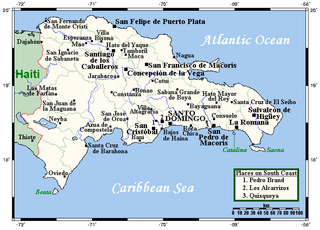
The Dominican Republic is a country in the West Indies that occupies the eastern five-eighths of Hispaniola. It has an area of 48,670 km², including offshore islands. The land border shared with Haiti, which occupies the western three-eighths of the island, is 376 km long. The maximum length, east to west, is 390 km from Punta de Agua to Las Lajas, on the border with Haiti. The maximum width, north to south, is 265 km from Cape Isabela to Cape Beata. The capital, Santo Domingo, is located on the south coast.

Hispaniola is an island in the Caribbean island group known as the Greater Antilles. It is the second largest island in the Caribbean after Cuba, and the most populous island in the Caribbean; it is also the eleventh most populous island in the world.

Santo Domingo, officially Santo Domingo de Guzmán, is the capital and largest city in the Dominican Republic and the largest metropolitan area in the Caribbean by population. In 2010, its population was counted as 965,040, rising to 2,908,607 when its surrounding metropolitan area was included. The city is coterminous with the boundaries of the Distrito Nacional, itself bordered on three sides by Santo Domingo Province.

Dominicans are people who are ethnically associated with the Dominican Republic. Dominican was historically the name for the inhabitants of the Captaincy General of Santo Domingo, and was retained after the nation's independence. The majority of Dominicans reside in the Dominican Republic, although there is also a large Dominican diaspora, mainly in the United States and Spain. The population of the Dominican Republic in 2016 was estimated at 10.2 million by the National Bureau of Statistics of the Dominican Republic..
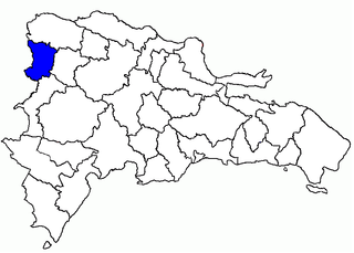
Dajabón is a province of the Dominican Republic, on the border with Haiti. Its capital city is also called Dajabón.
Elías Piña is one of the 32 provinces of the Dominican Republic. It is located in the western part of the country, on the border with Haiti. Its capital city is Comendador.
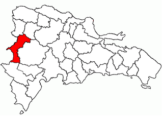
Santiago Rodríguez is a province of the Dominican Republic. It was split from Monte Cristi in 1948.
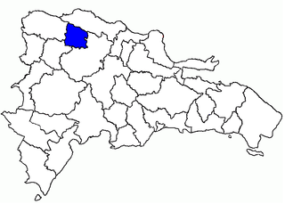
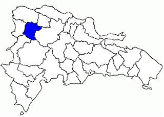
Valverde is a province of the Dominican Republic. It was split from Santiago Province in 1959. It is in the northwestern part of the country. Its capital city is Santa Cruz de Mao.

Larimar, also called "Stefilia's Stone", is a rare blue variety of the silicate mineral pectolite found only in the Dominican Republic, in the Caribbean. Its coloration varies from white, light-blue, green-blue to deep blue.
La Vega, or Concepción de La Vega is the third largest city and municipality of the Dominican Republic. It is in La Vega Province. The city is known as the heart of the Dominican Republic for its geographical position and its large agricultural production methods throughout its province.

The Parsley Massacre, took place in October 1937 against Haitians living in the Dominican Republic's northwestern frontier and in certain parts of the contiguous Cibao region. Dominican Army troops, who came from different areas of the country, carried out the massacre on the direct orders of the Dominican dictator Rafael Trujillo. Haitian President Élie Lescot put the death toll at 12,168; in 1953, the Haitian historian Jean Price-Mars cited 12,136 deaths and 2,419 injuries. In 1975, Joaquín Balaguer, the Dominican Republic's interim Foreign Minister at the time of the massacre, put the number of dead at 17,000. Other estimates compiled by the Dominican historian Bernardo Vega went as high as 35,000.

Maimón is a town in the Monseñor Nouel province of the Dominican Republic. Maimón is situated between Maimón river, La Leonora river, Yuna river and Zinc river, formed by a little valley and mountains in his sides. The colonies that were established in Bonao needed to encounter an easy lane to get to Concepción de la Vega, where was settled the general authorities at that time, the first Bonao was established in a little town that today is known as Sonador.
The following outline is provided as an overview of and topical guide to the Dominican Republic:

The following is an alphabetical list of topics related to the Dominican Republic.
Pueblo Viejo is a municipality (municipio) of the Azua province in the Dominican Republic.