Protected areas of South Australia consists of protected areas located within South Australia and its immediate onshore waters and which are managed by South Australian Government agencies. As of March 2018, South Australia contains 359 separate protected areas declared under the National Parks and Wildlife Act 1972, the Crown Land Management Act 2009 and the Wilderness Protection Act 1992 which have a total land area of 211,387.48 km2 (81,617.16 sq mi) or 21.5% of the state's area.
Woomera refers to Woomera (spear-thrower), an Indigenous Australian spear-throwing tool; other uses include:

Eyre Highway is a 1,660-kilometre (1,030 mi) highway linking Western Australia and South Australia via the Nullarbor Plain. Signed as National Highways 1 and A1, it forms part of Highway 1 and the Australian National Highway network linking Perth and Adelaide. It was named after explorer Edward John Eyre, who was the first European to cross the Nullarbor by land, in 1840–1841. Eyre Highway runs from Norseman in Western Australia, past Eucla, to the state border. Continuing to the South Australian town of Ceduna, it then crosses the top of the Eyre Peninsula before reaching the city of Port Augusta in South Australia.
Anangu Schools are schools in the Anangu Pitjantjatjara Yankunytjatjara (APY) in the north west of South Australia.

Flinders is a single-member electoral district for the South Australian House of Assembly. It is named after explorer Matthew Flinders, who was responsible for charting most of the state's coastline. It is a 58,901 km² coastal rural electorate encompassing the Eyre Peninsula and the coast along the Nullarbor Plain, based in and around the city of Port Lincoln and contains the District Councils of Ceduna, Cleve, Elliston, Lower Eyre Peninsula, Streaky Bay and Wudinna; as well as the localities of Fowlers Bay, Nullarbor and Yalata in the Pastoral Unincorporated Area. The seat was expanded in 2002 to include a western strip of land all the way to the Western Australia border.

The Maralinga Tjarutja is the corporation representing the traditional Anangu owners of the remote western areas of South Australia known as the Maralinga Tjarutja lands. It is one of the four regions local government areas of South Australia classified an Aboriginal Council (AC) and not incorporated within a local government area. This indigenous Australian people whose historic rights over the area have been officially recognised belongs to the southern branch of the Pitjantjatjara people. They have a community centre at Oak Valley, 520 miles NW of Ceduna, and close historical and kinship links with the Yalata 350km south, and the Pila Nguru centre of Tjuntjuntjara 370km to their west.

Nullarbor Regional Reserve is a protected area in South Australia located about 300 kilometres west of Ceduna.
Yatala may refer to any of the following items. For all Australian places named Yatala, the etymology at Hundred of Yatala applies.

Nundroo is a small South Australian town, located approximately 1,014 kilometres (630 mi) west of Adelaide. It is a popular rest stop for travellers due to its location on the Eyre Highway.

Gum Lagoon Conservation Park is an 8765 ha protected area about 40 km south-west of Keith in the Limestone Coast region of South Australia. It lies about 20 km inland from the southern end of the Coorong. It contains an isolated block of mallee woodland important for malleefowl conservation.
Mount Taylor Conservation Park is a protected area in the Australian state of South Australia located on Kangaroo Island in the gazetted locality of Newland. It was dedicated in 1970 primarily for the conservation of the rare triggerplant Stylidium tepperianum.

Nepean Bay Conservation Park is a protected area in the Australian state of South Australia on Kangaroo Island. It was dedicated in 1974 for the protection of flora and fauna, and is the only reserved area of coastal sandplain on the island.
Vivonne Bay Conservation Park, formerly the Vivonne Bay National Park, is a protected area in the Australian state of South Australia located on the south coast of Kangaroo Island in the gazetted locality of Vivonne Bay. It was dedicated in 1971 to conserve coastal country containing vegetation not already protected in Kelly Hill Conservation Park.

Lathami Conservation Park is a protected area in the Australian state of South Australia on the north coast of Kangaroo Island located in the locality of Cassini about 1 kilometre east of Stokes Bay and about 17 kilometres north of Parndana. It was proclaimed on 1 October 1987 to protect important nesting and foraging habitat for the Glossy Black Cockatoo, after which the conservation park was named.
Wahgunyah Conservation Park is a protected area located on the west coast of South Australia about 20 kilometres west of the town of Fowlers Bay. The conservation park is classified as an IUCN Category VI protected area.
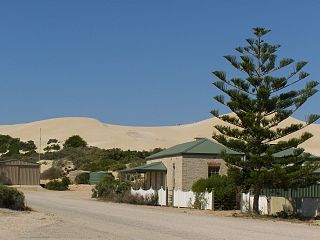
Fowlers Bay Conservation Park is a protected area located in the west of South Australia on the coastline of the Great Australian Bight in the gazetted locality of Fowlers Bay. The conservation park is classified as an IUCN Category VI protected area.
Nullarbor Wilderness Protection Area is a protected area in the Australian state of South Australia located about 270 kilometres west of Ceduna in the locality of Nullarbor.
Eucalyptus yalatensis, commonly known as the Yalata mallee, is a mallee that is native to parts of southern Australia.
This page is based on this
Wikipedia article Text is available under the
CC BY-SA 4.0 license; additional terms may apply.
Images, videos and audio are available under their respective licenses.