
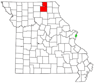
Adair County is a county located in the northeastern part of the U.S. state of Missouri. The population census for 2020 was 25,314. As of July 1, 2021, the U.S. Census Bureau's Population Estimates for the county is 25,185, a -0.5% change. Adair county seat is Kirksville. The county was first settled by immigrants from Kentucky and organized on January 29, 1841. Adair County comprises the Kirksville, MO Micropolitan Statistical Area.

Brashear is a city in Salt River Township, Adair County, Missouri, United States. The population was 273 at the 2010 census.

Gibbs is a village in Wilson Township, Adair County, Missouri, United States. The population was 107 at the 2010 census.
Kirksville is the county seat and most populous city in Adair County, Missouri. Located in Benton Township, its population was 17,530 at the 2020 census. Kirksville is home to two colleges: Truman State University and A.T. Still University.

Novinger is a town in Nineveh Township, Adair County, Missouri, United States. The population was 456 at the 2010 census.
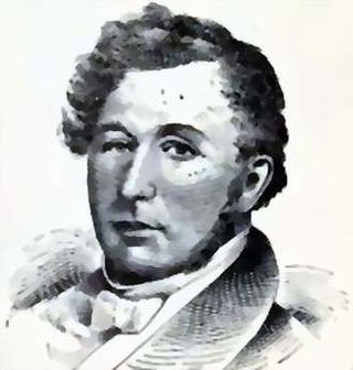
John Miller was an American publisher, War of 1812 veteran, and politician from Missouri. A Democrat, Miller was the fourth Governor of Missouri before serving three terms in the United States House of Representatives from 1837 to 1843.

Thousand Hills State Park is a public recreation area covering some 3,000 acres (1,200 ha) two miles (3.2 km) west of Kirksville in Adair County, Missouri. The state park features 703-acre (284 ha) Forest Lake and Native American petroglyphs.

The Chariton River is a 218-mile-long (351 km) tributary to the Missouri River in southeast Iowa and northeast Missouri. The river forms in southeastern Clarke County, Iowa. It is dammed at 11,000-acre (45 km2) Rathbun Reservoir in Appanoose County, Iowa and then flows 30 miles (48 km) before entering Missouri where it forms the boundary between Putnam and Schuyler counties. It enters the Missouri River in Chariton County near Keytesville. 112 miles (180 km) are in Missouri and 106 miles (171 km) are in Iowa. The river has been called Missouri's "Grand Divide" because streams west of the Chariton flow into the Missouri and streams east of it flow into the Mississippi River.
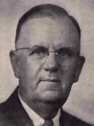
Samuel Washington (Wat) Arnold was a U.S. Representative from Missouri.
The Kirksville Micropolitan Statistical Area, as defined by the United States Census Bureau, is an area consisting of two counties in Missouri, anchored by the city of Kirksville. As of the 2000 census, the μSA had a population of 29,147, and in the 2010 census the population was 30,008.

KIRX is a radio station licensed to the city of Kirksville, Missouri and serves the northeast Missouri area.

Adair County R-1, also known as Novinger R-1 is a public school district located in Adair County, Missouri. It serves a largely rural population in western Adair County, along with the town of Novinger, Missouri, providing pre-Kindergarten through 12th grade education.

Zachary Wyatt is an American politician from the state of Missouri. A Republican, Wyatt was a one-term member of the Missouri House of Representatives from the 2nd District, encompassing Adair county, Putnam county, and a part of Sullivan county. In May 2012, Representative Wyatt became, at that time, the nation's only openly gay Republican legislator. He "came out" during a press conference in the Missouri Capitol, while opposing the "Don't Say Gay" bill. Due to Missouri House redistricting following the 2010 U.S. Census the 2nd district was divided into two newly numbered districts. Representative Wyatt had originally filed to run for the 3rd district, which includes most of his former 2nd district territory. However, in early April 2012 he announced his intention to withdraw once a suitable Republican replacement could be named. Wyatt stated his withdrawal was prompted by his acceptance into a marine biology program at the University of Hawaii, and his desire to take full advantage of his veterans education benefits. In the November general election Republican Nate Walker defeated Democrat Rebecca McClanahan, Wyatt's opponent in 2010, to win the 3rd district seat and succeed Wyatt.
The Iowa and St. Louis Railway (I&SL) was a subsidiary United States railroad operating in south-east Iowa and north-east Missouri from 1902 to 1947. For most of its existence it was part of the Chicago, Burlington and Quincy Railroad (CBQ), familiarly known as the Burlington System.

St. Mary's Church is a historic turn-of-the-20th century Catholic church located in the unincorporated community of Adair, 12 miles northeast of Kirksville, Adair County, Missouri, on Missouri Route 11. An example of Romanesque Revival architecture, it is one of the few wood-frame structures in that style still remaining in the United States. St. Mary's was constructed in 1904, and was added to the National Register of Historic Places in 1974. It is now owned and managed by Friends of St. Mary's, a non-profit preservation organization.

The Kirksville Daily Express is a bi-weekly newspaper published Wednesday and Saturday. It serves the Kirksville and Adair County, Missouri area including the communities of Brashear and Novinger. It is owned by Phillips Media Group.

Adair, Missouri is an unincorporated community in eastern Adair County, Missouri, United States. It is located approximately 12 miles northeast of Kirksville, on Missouri Route 11. Adair is notable as the location of St. Mary's Church, which is on the National Register of Historic Places.
Connelsville is an unincorporated community in Nineveh Township, Adair County, Missouri, United States. The community is on Missouri Route 149 about three miles north of Novinger and eight miles northwest of Kirksville. Shuteye Creek flows past the north side of the town and its confluence with the Chariton River is about one mile to the east.
Stahl is an unincorporated community in northwest Adair County, Missouri, United States. The community is on Missouri Route O about six miles northwest of Novinger and 12 miles northwest of Kirksville. There are only three houses at Stahl, and an abandoned car dump along the highway. The Union Ridge Conservation Area lies to the west about two miles and Spring Creek flows past the community to its confluence with the Chariton River south of Novinger.
Spring Creek is a stream in Putnam, Sullivan and Adair counties of northern Missouri. It is a tributary of the Chariton River.


