
Kershaw County is a county located in the U.S. state of South Carolina. As of the 2020 census, its population was 65,403, up from 61,697 in 2010. The county seat and largest city is Camden. The county was created in 1791 from parts of Claremont, Lancaster, Fairfield, and Richland counties. It is named for Col. Joseph Kershaw (1727–1791), an early settler and American Revolutionary War patriot.
Camden is a city in Kershaw County, South Carolina, United States. It is the largest city and county seat of Kershaw County. The population was 6,838 in the 2010 census and an estimated 7,196 in 2018. It is part of the Columbia, South Carolina, Metropolitan Statistical Area. Camden is the oldest inland city in South Carolina, and home to the Carolina Cup and the National Steeplechase Museum.

Kershaw is a town in Lancaster County, South Carolina, United States. It was incorporated in 1888. As of the 2010 census, the population was 1,803, and as of 2019 the estimated population was 2,321. The Haile Gold Mine, where gold was discovered in 1825, is 3 miles (5 km) from town and was at one time the largest single producer of gold in the Appalachian region.
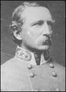
Joseph Brevard Kershaw was a prominent South Carolina planter and slaveholder. He was also a lawyer, judge, and a Confederate general in the American Civil War.

Camden station, also known as the Seaboard Air Line Railroad Depot, is a train station in Camden, South Carolina. It serves Amtrak, the national passenger rail service. The station was built by the Seaboard Air Line Railroad in 1937. It is located on 1100 West DeKalb Street, although some sources give the address as being at 1060 West DeKalb Street. Either way, it was named to the National Register of Historic Places in 2000. The station is in disrepair, and a renovation project is scheduled to commence in August 2014. The station renovations were completed in early 2016.

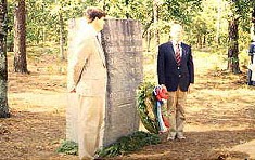
John Cantey Villepigue was a corporal in the 118th Infantry, 30th Division which was federalized out of the South Carolina National Guard during World War I. He received the Medal of Honor for his actions during that war.

Bethesda Presbyterian Church is a historic church at 502 DeKalb Street in Camden, South Carolina. A National Historic Landmark, the main church building was built in 1822 and is one of few surviving churches designed by 19th-century American architect Robert Mills. The current minister is Rev. Jim Davis.
The Camden Battlefield is the site of the Battle of Camden on 16 August 1780, a British victory by General Charles Cornwallis over a mixed force of Continental Army regulars and state militia forces led by General Horatio Gates. The battlefield sprawls over an area estimated to be 2,000 acres (8.1 km2) about 6 miles (9.7 km) north of Camden, South Carolina, bounded on the north by Lake Shamokin, and extending south. Flat Rock Rd (S-28-58) passes roughly through the center of the battlefield, and United States Route 521 marks its eastern boundary. It was declared a National Historic Landmark in 1961.

Mulberry Plantation, also known as the James and Mary Boykin Chesnut House is a historic plantation at 559 Sumter Highway south of Camden, South Carolina. Declared a National Historic Landmark in 2000, it is significant as the home of American Civil War chronicler Mary Boykin Chesnut, who produced some of the most important written accounts of the war from a Confederate perspective. The main house, built about 1820, is a fine example of Federal period architecture.

The High Hills of Santee, sometimes known as the High Hills of the Santee, is a long, narrow hilly region in the western part of Sumter County, South Carolina. It has been called "one of the state's most famous areas". The High Hills of Santee region lies north of the Santee River and east of the Wateree River, one of the two rivers that join to form the Santee. It extends north almost to the Kershaw county line and northeasterly to include the former summer resort town of Bradford Springs. Since 1902 the town has been included in Lee County.
Carter Hill is a historic plantation complex located near Camden, Kershaw County, South Carolina. The overseer's house was built about 1840, and now incorporated into the main house built about 1875. The overseer's house was a one-room house, that incorporates architectural elements in the Greek Revival style. The main house reflects the rural Victorian architectural style predominant after the American Civil War. Also on the property are a log building, a frame building, a pump house, a smokehouse, a dovecote, a hen house, and a barn constructed at various times during the 19th century. It was listed on the National Register of Historic Places in 1992.
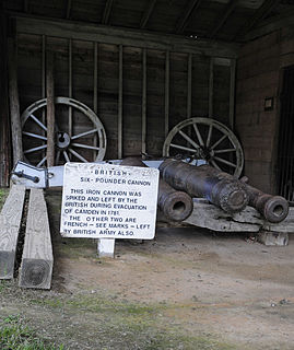
Historic Camden Revolutionary War Site is a national historic district and open-air museum located in Camden, Kershaw County, South Carolina, United States. Roughly 40 minutes away from Columbia, the state capitol, it is one of the state's largest tourist attractions. The 107-acre site is also known as Historic Camden Revolutionary War Restoration, and as the British Revolutionary War Fortifications. Camden contains preserved structures and grounds that are representative of the Southern theater of the American Revolutionary War. The site is managed by a consortium of private donors and local governments. The area is also an affiliated unit of the National Park Service.
The Adamson Mounds Site (38KE11) is an archaeological site located near Camden, Kershaw County, South Carolina. It is a prehistoric Native American village site containing one large platform mound, a smaller mound, possibly a third still smaller mound, and a burial area. It served as a regional ceremonial center. This site represents a widespread, late prehistoric Mississippian culture known by the names of Lamar, Irene, or Pee Dee and dates probably between AD 1400 and AD 1700.
The McDowell Site, also known as Chesnut Mounds, Taylor Mounds, and Mulberry Plantation House, is a set of historic mounds located near Camden, Kershaw County, South Carolina. The McDowell Site is among the first archaeological sites to be carefully excavated and archaeologically reported in the United States. It represents a widespread late prehistoric Indian culture known by the names of Lamar, Irene, and Pee Dee, and possibly extends into protohistoric and historic times. It probably dates between AD 1400 and AD 1700.
The Belmont Neck Site is a historic archaeological site located near Camden, Kershaw County, South Carolina. From about 950 to 1300 A.D., the Belmont Neck Site was the location of a platform mound and town associated with the Native American chiefdom of Cofitachequi. It appears to be the first of 12 mound towns along the Catawba/Wateree River. From approximately 1772 to 1796, it was the location of indigo production by Colonel John Chesnut of Camden.

Cool Springs is a historic home located near Camden, Kershaw County, South Carolina. It was built about 1832, and is a two-story Greek Revival style house on a raise brick basement. The original house was remodeled in the 1850s. It features a tiered portico and verandahs, supported by 64 Doric order columns. A two-story kitchen addition was attached to the house about 1935. Also on the property are the contributing two horse stables, a concrete piscatory, an old stone spring, a brick basin, a dam, and granite gate posts.

Thomas English House, also known as the Murchison House, is a historic home located at Camden, Kershaw County, South Carolina. It was built about 1800, and is a two-story, five-bay, hip-roofed, frame and beaded weatherboard Federal I-house. It is set on brick piers connected by a recessed, stucco-covered, concrete block curtain wall. The front façade features a one-story, full-length, hip-roofed porch.

Boykin Mill Complex, also known as Mill Tract Plantation, is a national historic district located near Camden, Kershaw County, South Carolina. The district encompasses nine contributing buildings, two contributing sites, and four contributing structures. “Boykin Mill” denotes a community which consists of an old post office, an old general store, a c. 1905 grist mill, mill pond, mill dam, gates, and canals. The community also includes an early 19th-century Greek Revival style Baptist church, one mid-19th-century residence, three 20th-century residences built for mill workers, and a smoke house. An American Civil War battle site is also a part of the Boykin Mill community. The Battle of Boykin's Mill took place on April 17, 1865.
City of Camden Historic District is a national historic district located at Camden, Kershaw County, South Carolina. The district encompasses 48 contributing buildings, 8 contributing sites, 2 contributing structures, and 3 contributing objects in Camden. The district is mostly residential but also include public buildings, a church, and a cemetery. Camden's architecture is classically inspired and includes examples of Federal, Greek Revival, and Classical Revival, in addition to cottage-type, Georgian, Charleston-type with modifications, and mansion-type houses. Several of the city's buildings were designed by architect Robert Mills. Notable buildings include the Kershaw County Courthouse (1826), U.S. Post Office, Camden Opera House and Clock Tower, Camden Powder Magazine, Trinity United Methodist Church, St. Mary's Catholic Church, Gov. Fletcher House, Greenleaf Villa, The First National Bank of Camden, and the separately listed Bethesda Presbyterian Church and Kendall Mill.

Kendall Mill Historic District is a historic mill complex, mill village, and national historic district located at Camden, Kershaw County, South Carolina. The district encompasses 119 contributing buildings, 1 contributing sites, and 1 contributing structure in Camden. The district is centered on the Wateree Plant and associated structures that date from 1899 to 1923. The mill village to the south and southeast of the plant was built between 1900 and ca. 1925 and is a virtually intact reminder of the importance of the textile industry to South Carolina. The mill faces Kendall Park, a ten-acre landscaped park. On the eastern border of the park are the mill supervisors’ houses, built between 1900 and ca. 1925. The operatives house consist of one-story, 1 1/2-story, and a few two-story frame houses which date from 1900 to 1923. The district also includes Kendall Lake, north of the mill. The Dekalb Cotton Mill was organized in 1899. The Dekalb Mill building, designed by W.B. Smith Whaley in the Romanesque Revival style, was considered a model of textile architecture. The original plant building is a four-story rectangular brick building with a back stair tower and an imposing six-story front stair tower. The west addition to the plant, which is in keeping, architecturally, with the older buildings, was constructed in 1964. It is located in the City of Camden Historic District.


