Épaule du Marboré

Last updated
Épaule du Marboré

Breche004.jpg

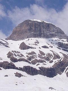
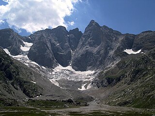
De gauche (est) à droite (ouest) : pic du Marboré, pic de la cascade oriental, pic de la cascade central ou pic Brulle, pic de la cascade occidental, épaule du Marboré, tour du Marboré, casque du Marboré, et refuge des Sarradets. Au centre, cascade de Gavarnie. Voir encadrements des photographies n°1 et n°2 sur Commons.
Highest point
Elevation 3,073 m (10,082 ft)
Prominence 15 metres (49 ft)
Listing List of Pyrenean three-thousanders
Coordinates 42°41′07″N0°00′00″E / 42.68528°N 0.00000°E / 42.68528; 0.00000 Coordinates: 42°41′07″N0°00′00″E / 42.68528°N 0.00000°E / 42.68528; 0.00000 [1]
Geography
Pyrenees topographic map-en.svg
Red triangle with thick white border.svg
Épaule du Marboré
Location in the Pyrenees
Location France Spain
Région
Communauté
Midi-Pyrénées
Aragon
Département
Province
Hautes-Pyrénées
Huesca
Parent range Massif du Mont-Perdu (Pyrenees)
Climbing
First ascent August 12, 1891 by Henri Brulle, C. Passet and François Bernat-Salles

Épaule du Marboré is a pyrenean summit, culminating at 3,073 m (10,082 ft) in the Monte Perdido Range, marking the Franco-Spanish border. It lies on the Greenwich meridien.

Pyrenees Range of mountains in southwest Europe

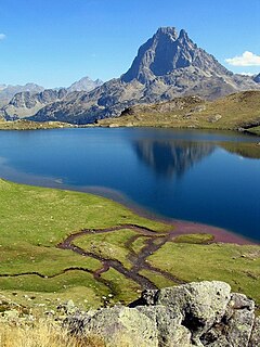
The Pyrenees is a range of mountains in southwest Europe that forms a natural border between Spain and France. Reaching a height of 3,404 metres (11,168 ft) altitude at the peak of Aneto, the range separates the Iberian Peninsula from the rest of continental Europe, and extends for about 491 km (305 mi) from the Bay of Biscay to the Mediterranean Sea.

Prime meridian (Greenwich) meridian

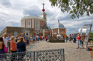
A prime meridian, based at the Royal Observatory, Greenwich, in London, England, was established by Sir George Airy in 1851. By 1884, over two-thirds of all ships and tonnage used it as the reference meridian on their charts and maps. In October of that year, at the behest of US President Chester A. Arthur, 41 delegates from 25 nations met in Washington, D.C., United States, for the International Meridian Conference. This conference selected the meridian passing through Greenwich as the official prime meridian due to its popularity. However, France abstained from the vote, and French maps continued to use the Paris meridian for several decades. In the 18th century, London lexicographer Malachy Postlethwayt published his African maps showing the "Meridian of London" intersecting the Equator a few degrees west of the later meridian and Accra, Ghana.

Contents

Geography

L'Epaule L'Epaule Gavarnie.JPG
L'Épaule

Topography

The Tour du Marboré forms part of the range above Cirque de Gavarnie. It marks the border between the Pyrenees National Park of France and the Ordesa y Monte Perdido National Park of Spain.

Cirque de Gavarnie glacial cirque in France

The Cirque de Gavarnie is a cirque in the central Pyrenees, in Southwestern France, close to the border of Spain. It is within the commune of Gavarnie, the department of Hautes-Pyrénées, and the Pyrénées National Park. Major features of the cirque are La Brèche de Roland and the Gavarnie Falls. It was described by Victor Hugo as "the Colosseum of nature" due to its enormous size and horseshoe shape resembling an ancient amphitheatre.

France Republic with mainland in Europe and numerous oversea territories

France, officially the French Republic, is a country whose territory consists of metropolitan France in Western Europe and several overseas regions and territories. The metropolitan area of France extends from the Mediterranean Sea to the English Channel and the North Sea, and from the Rhine to the Atlantic Ocean. It is bordered by Belgium, Luxembourg and Germany to the northeast, Switzerland and Italy to the east, and Andorra and Spain to the south. The overseas territories include French Guiana in South America and several islands in the Atlantic, Pacific and Indian oceans. The country's 18 integral regions span a combined area of 643,801 square kilometres (248,573 sq mi) and a total population of 67.3 million. France, a sovereign state, is a unitary semi-presidential republic with its capital in Paris, the country's largest city and main cultural and commercial centre. Other major urban areas include Lyon, Marseille, Toulouse, Bordeaux, Lille and Nice.

Ordesa y Monte Perdido National Park national park

Ordesa y Monte Perdido National Park is an IUCN Category II National Park situated in the Pyrenees of Huesca province, Aragon, Spain. There has been a National Park in the Ordesa Valley since 1918. Its protected area was enlarged in 1982 to cover the whole region amounting to 156.08 km².

On the French side, it is located in the commune of Gavarnie in the canton of Luz-Saint-Sauveur, Hautes-Pyrénées department, Midi-Pyrénées region.

Gavarnie Place in Occitanie, France

Gavarnie is a former commune in the Hautes-Pyrénées department in south-western France. On 1 January 2016, it was merged into the new commune of Gavarnie-Gèdre. Gavarnie is known for the Cirque de Gavarnie, and the Gavarnie Falls in it, part of the UNESCO World Heritage Site Pyrénées – Mont Perdu.

Luz-Saint-Sauveur Commune in Occitanie, France

Luz-Saint-Sauveur is a commune in the Hautes-Pyrénées department in the Occitan region of south-western France. Locals simply call it Luz, the city took its current name from Luz-Saint-Sauveur on April 9, 1962. Its inhabitants are called the Luzeans. In the village, you can enjoy the exceptional historical heritage of the town by visiting the church of Saint-André but also known as "Les Templiers", but also the Pont Napoléon, the Château Sainte-Marie or the spa district. Protected by mountains to the east, west and south, and separated from the plain to the north by the Pierrefitte gorge, Luz-Saint-Sauveur feels like it is cut off from the outside world even though it is only a 1/2 hour drive from Lourdes.

Hautes-Pyrénées Department of France

Hautes-Pyrénées is a department in southwestern France. It is part of the Occitanie region.

Related Research Articles

Province of Huesca Province of Spain

Huesca, officially Huesca/Uesca, is a province of northeastern Spain, in northern Aragon. The capital is Huesca.

Pyrénées National Park national park of France

The Pyrénées National Park is a National Park of France located within the French departments of Hautes-Pyrénées and Pyrénées-Atlantiques.

Rolands Breach

Roland's Breach is the name of a natural gap, 40 m across and 100 m high, at an elevation of 2804 m in the Pyrenees on the border of Aragón, northern Spain, and Hautes-Pyrénées, France.

Monte Perdido mountain in Huesca

Monte Perdido is the third highest mountain in the Pyrenees. The summit of Monte Perdido (3355 m), located in Spain, lies hidden from France by the seemingly impenetrable peaks of the Cirques of Gavarnie and Estaubé. It stands in the north of Huesca province. The mountain forms part of the Monte Perdido Range and is located in the Ordesa y Monte Perdido National Park, in the western part of the Pyrenees, in the community of Aragon, Spain.

Ordesa Valley

The Ordesa Valley is a glacial valley in Aragon, in the Spanish Pyrenees which forms part of the Ordesa y Monte Perdido National Park. It was first discovered in 1820, but not mapped in detail until approximately the 1920s. The valley is about 11 kilometres (7 mi) long.

Soum de Ramond mountain in Spain

Soum de Ramond, also known as Pico de Añisclo in Spanish and Aragonese, is a mountain of 3,263 metres in the Monte Perdido massif in the Aragonese Pyrenees in northern Spain. It is one of the three mountains comprising Las Tres Sorores, the others being Monte Perdido and Cilindro de Marboré.

Cilindro de Marboré mountain

Cilindro de Marboré is a mountain in the Monte Perdido massif in the Pyrenees.

Pyrénées – Mont Perdu World Heritage Site

The Pyrénées – Mont Perdu World Heritage Site is a World Heritage site straddling the border between Spain and France in the Pyrenees mountain chain. The summit of Monte Perdido is on the Spanish side of the border. The site was designated in 1997 and extended north in 1999 to include the Commune of Gèdre in France.

Góriz or Refuge of Góriz, is a mountain refuge located in the province of Huesca in the Spanish Pyrenees. The hut is a hub of different treks in the area, like GR 11 or Monte Perdido climb. It can guest 72 people and used to be full so it used to be necessary to book in advance. Its height is 2,195 metres (7,201 ft) and its coordinates are N 42° 39,783′ E 000° 00.911′.

Pic de Marboré mountain in France and Spain

Marboré Peak is a summit in the Pyrenees located on the Franco-Spanish border crest in the Monte Perdido Range.

Clot de la Hount mountain in France

The Clot de la Hount or pic du clot de la Hount is a summit of the Pyrenees, located on the Franco-Spanish border in the Vignemale Massif, of which it is the second highest summit in the range, at 3,289 m, after Pique Longue.

Casque du Marboré mountain in France

The Casque du Marboré, or Casque de Gavarnie or simply le Casque, is a pyrenean summit, culminating at 3,006 m (9,862 ft), located on the crest of three-thousanders in the Monte Perdido Range above Cirque de Gavarnie on the Franco-Spanish border.

Tour du Marboré mountain in France

Tour du Marboré or Tour de Gavarnie is a pyrenean summit, culminating at 3,009 m (9,872 ft), located on the Franco-Spanish border crest in the Monte Perdido Range.

Pic du Taillon mountain in France

Pic du Taillon or Pico Taillón is a summit in the Pyrenees, culminating at 3,144 m (10,315 ft) on the Franco-Spanish border in the Monte Perdido Range.

Cascade Peaks

The Cascade Peaks are three summits in the Monte Perdido Range of the Pyrenees, culminating at 3,161 m (10,371 ft) on the eastern peak. The central peak, known as Brulle, and the western peak are 3,106 m (10,190 ft) and 3,095 m (10,154 ft) high, respectively. The peaks are located on the 3,000 m French-Spanish borderline crest.

Refuge des Sarradets

Le refuge des Sarradets, or refuge de la Brèche de Roland is a mountain refuge in the Pyrenees. It is located in Gavarnie, near la brèche de Roland, in the Pyrenees National Park, at 2,587 m (8,488 ft) high.

References

  1. Source : Géoportail