
The Cook Islands is a self-governing island country in the South Pacific Ocean in free association with New Zealand. It comprises 15 islands whose total land area is 240 square kilometres (92.7 sq mi). The Cook Islands' Exclusive Economic Zone (EEZ) covers 1,800,000 square kilometres (690,000 sq mi) of ocean.
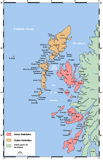
The Hebrides comprise a widespread and diverse archipelago off the west coast of mainland Scotland. There are two main groups: the Inner and Outer Hebrides. These islands have a long history of occupation dating back to the Mesolithic, and the culture of the residents has been affected by the successive influences of Celtic, Norse, and English-speaking peoples. This diversity is reflected in the names given to the islands, which are derived from the languages that have been spoken there in historic and perhaps prehistoric times.

The Outer Hebrides, also known as the Western Isles, Innse Gall or the Long Isle or the Long Island, is an island chain off the west coast of mainland Scotland. The islands are geographically coextensive with Comhairle nan Eilean Siar, one of the 32 unitary council areas of Scotland. They form part of the archipelago of the Hebrides, separated from the Scottish mainland and from the Inner Hebrides by the waters of the Minch, the Little Minch, and the Sea of the Hebrides. Scottish Gaelic is the predominant spoken language, although in a few areas English speakers form a majority.
The Seychelles is a small island nation located in the Somali sea northeast of Madagascar and about 835 mi (1,344 km) from Mogadishu, Somalia, its nearest foreign mainland city, while Antsiranana is the nearest foreign city overall. Seychelles lies between approximately 4ºS and 10ºS and 46ºE and 54ºE. The nation is an archipelago of 115 tropical islands, some granite and some coral. the majority of which are small and uninhabited. The landmass is only 459 km2, but the islands are spread over an Exclusive Economic Zone of 1,374,000 km2. About 90 percent of the population of 90,000 live on Mahé, 9 percent on Praslin and La Digue. Around a third of the land area is the island of Mahé and a further third the atoll of Aldabra.

Cape Hatteras is a thin, broken strand of islands in North Carolina that arch out into the Atlantic Ocean away from the US mainland, then back toward the mainland, creating a series of sheltered islands between the Outer Banks and the mainland. For thousands of years these barrier islands have survived onslaughts of wind and sea. Long stretches of beach, sand dunes, marshes, and maritime forests create a unique environment where wind and waves shape the topography. A large area of the Outer Banks is part of a National Park, called the Cape Hatteras National Seashore. It is also the nearest landmass on the US mainland to Bermuda, which is about 563 nautical miles to the east-southeast.
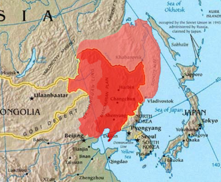
Outer Manchuria is an unofficial term for a territory in Northeast Asia that was formerly controlled by the Qing dynasty and now belongs to Russia. It is considered part of Manchuria by some definitions. Russia officially received this territory by way of the Treaty of Aigun in 1858 and the Treaty of Peking in 1860. The northern part of the area was also in dispute between 1643 and 1689.

Boston Harbor is a natural harbor and estuary of Massachusetts Bay, and is located adjacent to the city of Boston, Massachusetts. It is home to the Port of Boston, a major shipping facility in the northeastern United States.
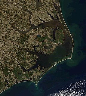
The Outer Banks is a 200-mile-long (320 km) string of barrier islands and spits off the coast of North Carolina and southeastern Virginia, on the east coast of the United States. They cover most of the North Carolina coastline, separating Currituck Sound, Albemarle Sound, and Pamlico Sound from the Atlantic Ocean.
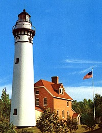
The Outer Island lighthouse is a lighthouse located on the northern tip of Outer Island, one of the Apostle Islands, in Lake Superior in Ashland County, Wisconsin, near the city of Bayfield.
The Outer Islands or Coralline Seychelles (archipelago) is a collective term for those islands of the Seychelles that are not on the shallow Seychelles Bank which defines the location of the granitic Inner Islands archipelago to the east. The local Seychellois Creole name for the outer islands is Zil Elwannyen Sesel, while the French name is Îles Eloignées. They are all of coral formation, and in the western Indian Ocean.
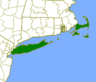
The Outer Lands is the prominent terminal moraine archipelagic region off the southern coast of New England in the United States. This eight-county region of Massachusetts, Rhode Island, and New York, comprises the peninsula of Cape Cod and the islands of Martha's Vineyard, the Elizabeth Islands, Nantucket, Block Island, and Long Island, as well as surrounding islands and islets.

Outer Brewster Island, also known as Outward Island, is one of the outer islands in the Boston Harbor Islands National Recreation Area and is situated some 10 miles offshore of downtown Boston. The island has a permanent size of 20 acres, and consists of exposed bedrock covered by fertile soil bounded by a rocky shore with steep cliffs. It provides a nesting habitat for coastal water birds, including cormorants, gulls, common eider ducks, glossy ibis and American oystercatchers. The birds are aggressive during their nesting season and access by humans, which is by private boat only, is discouraged during this period.

The Principality of Outer Baldonia is a now defunct micronation whose territorial pretensions comprised the roughly 4 acres (16,000 m2) of Outer Bald Tusket Island, the southernmost of the Tusket Islands, 8 nautical miles (15 km) off the southern tip of the Canadian province of Nova Scotia.

Outer Sister Island, part of the Sister Islands Conservation Area, is a granite and dolerite island, with an area of 545 hectares (2.10 sq mi), located in Bass Strait, Tasmania, Australia.
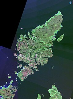
Lewis and Harris is a Scottish island in the Outer Hebrides. It is the largest island in Scotland and the third largest in the British Isles,

The Malpeque Outer Range Lights are a set of range lights on Prince Edward Island, Canada. They were built in 1922, and are still active.
The Summerside Outer Range Lights are a set of range lights near Summerside, Prince Edward Island, Canada. They were built in 1991, and are still active.
China declared its baselines for its maritime territory on 15 May 1996. The baselines were for the Chinese mainland and also for the Paracel (Xisha) Islands.

Tasiusaq Island is an island in the Qaasuitsup municipality in northwestern Greenland, home to the Tasiusaq settlement.
High Tider or Hoi Toider is a dialect of American English spoken in very limited communities of the South Atlantic United States—particularly, several small island and coastal townships in the rural North Carolina "Down East" that encompasses the Outer Banks and Pamlico Sound as well as in the Chesapeake Bay. The term is also a local nickname for any native resident of these regions.


