Adamson Landing Field

Last updated
Adamson Landing Field

Adamson Landing Field - California.jpg

2006 USGS airphoto
Summary
Serves Olancha, California
Coordinates 36°15′23″N117°59′52″W / 36.25639°N 117.99778°W / 36.25639; -117.99778 Coordinates: 36°15′23″N117°59′52″W / 36.25639°N 117.99778°W / 36.25639; -117.99778
Map
USA California location map.svg
Airplane silhouette.svg
Adamson Landing Field
Location of Adamson Landing Field
Runways
Direction Length Surface
ft m
00/18 2,700 823 Turf
09/27 1,000 305 Turf

Adamson Landing Field is a closed airport located 1.8 mi south-southeast of Olancha, California.

Olancha, California Census designated place in California, United States

Olancha is a census designated place in Inyo County of the U.S. state of California. Olancha is located on U.S. Route 395 in California, 37 miles (60 km) south-southeast of Independence, at an elevation of 3658 feet. As of the 2010 census, the population was 192, up from 134 at the 2000 census.

Contents

History

During World War II, the airport was used by the United States Army Air Forces as an auxiliary training airfield for the flying school at Lone Pine Airport, California.

World War II 1939–1945 global war

World War II, also known as the Second World War, was a global war that lasted from 1939 to 1945. The vast majority of the world's countries—including all the great powers—eventually formed two opposing military alliances: the Allies and the Axis. A state of total war emerged, directly involving more than 100 million people from over 30 countries. The major participants threw their entire economic, industrial, and scientific capabilities behind the war effort, blurring the distinction between civilian and military resources. World War II was the deadliest conflict in human history, marked by 50 to 85 million fatalities, most of whom were civilians in the Soviet Union and China. It included massacres, the genocide of the Holocaust, strategic bombing, premeditated death from starvation and disease, and the only use of nuclear weapons in war.

United States Army Air Forces Aerial warfare branch of the United States army from 1941 to 1947

The United States Army Air Forces, informally known as the Air Force,or United States Army Air Force, was the aerial warfare service of the United States during and immediately after World War II (1939/41–1945), successor to the previous United States Army Air Corps and the direct predecessor of the United States Air Force of today, one of the five uniformed military services. The AAF was a component of the United States Army, which in 1942 was divided functionally by executive order into three autonomous forces: the Army Ground Forces, the Services of Supply, and the Army Air Forces. Each of these forces had a commanding general who reported directly to the Army Chief of Staff.

Lone Pine Airport

Lone Pine Airport is a public airport located one mile (1.6 km) southeast of Lone Pine serving Inyo County, California, USA. The airport has two runways and is mostly used for general aviation. Charts: San Francisco; L5.

The facility closed sometime after the war. The remains of the runways and ground facilities can be seen in aerial imagery.

See also

Related Research Articles

Vernouillet, Eure-et-Loir Commune in Centre-Val de Loire, France

Vernouillet is a commune in the Eure-et-Loir department in northern France.

Mariposa-Yosemite Airport airport

Mariposa-Yosemite Airport is a public airport located four miles (6 km) west of the central business district of Mariposa, in Mariposa County, California, United States. It is owned by the County of Mariposa.

Needles Airport

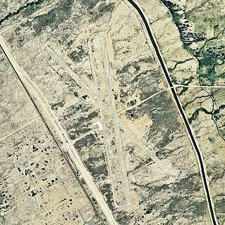
Needles Airport is a county-owned public airport in San Bernardino County, California, five miles (9 km) south of Needles.

Oklahoma World War II Army Airfields

During World War II, the United States Army Air Forces (AAF) established numerous airfields in Oklahoma for training pilots and aircrews of AAF fighters and bombers or as major maintenance and supply centers.

Perry–Foley Airport

Perry–Foley Airport is a public-use airport located 3 miles (4.8 km) south of the central business district of the city of Perry in Taylor County, Florida, United States. The airport is publicly owned.

Porterville Municipal Airport

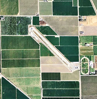
Porterville Municipal Airport is a city-owned public-use airport located three nautical miles southwest of the central business district of Porterville, a city in Tulare County, California, United States. According to the FAA's National Plan of Integrated Airport Systems for 2009–2013, it is categorized as a general aviation facility.

Hillsborough Army Air Field

Hillsborough Army Airfield is a former World War II United States Army Air Forces airfield which was located about 7 miles north of Tampa, Florida, near Temple Terrace, Florida. After World War II it served as a civilian airport called Henderson Hillsborough International Airport for several years until it closed.

Imeson Field

Imeson Field, also known as Jacksonville Imeson Airport, was the airport serving Jacksonville, Florida, from 1927 until its closing in 1968. It was known as Jacksonville Municipal Airport prior to World War II, Jacksonville Army Airfield when the United States Army Air Forces controlled the facility during World War II, and at its closing the airport was Jacksonville - Thomas Cole Imeson Municipal Airport.

Corcoran Airport airport in California, United States

Corcoran Airport was a public use airport located two nautical miles (3.7 km) west of the central business district of Corcoran, a town in Kings County, California, United States. It is privately owned by Lakeland Dusters, Inc. The airport has been permanently closed.

Casablanca–Anfa Airport airport in Morocco

Casablanca–Anfa Airport was an airport in Morocco (IATA: CAS, ICAO: GMMC), located about 6 kilometres (4 mi) southwest of Casablanca. Anfa Airport was one of three airports serving the Casablanca area, the others being the newer and larger Mohammed V International Airport and the Casablanca Tit Mellil Airport.

Grand Island Army Air Field

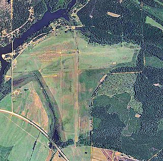
Grand Island Army Airfield was a United States Army Air Forces airfield which operated from 1942 to 1946. After its closure, the base was reopened as Central Nebraska Regional Airport.

Hancock Field (California)

Hancock Field is a former airport and military airfield about 2 miles (3.2 km) south-southeast of Santa Maria, California. Also known as Santa Maria Municipal Airport, the airport was closed about 1959 and today is the site of Allan Hancock College.

Lancaster Airport was an airport about 1.5 miles (2.4 km) northwest of Lancaster, California. It was closed in the late 1940s and is now a housing development.

Amedee Army Airfield

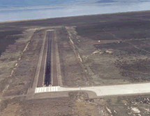
Amedee Army Airfield is a military use airport located nine nautical miles (17 km) north of the central business district of Herlong, in Lassen County, California, United States. It is owned by the United States Army and located at the Sierra Army Depot in the Honey Lake Valley, east of the Sierra Nevada mountain range.

Coalinga Municipal Airport (Old)

Coalinga Municipal Airport (Old) is a closed airport located 1 mile north of Coalinga, California. The airport was closed approximately 2000, all aviation use was moved to the New Coalinga Municipal Airport.

Kingdon Airpark

Kingdon Airpark is a general aviation airport located 4 miles southwest of Lodi, California.

Inyo County Airport

Inyo County Airport is a closed airport located east of Fresno, California.

Henderson Airport (Alabama)

Henderson Airport is a closed airport located two miles (3.2 km) north-northeast of Millers Ferry, Alabama. During World War II, it operated as Henderson Auxiliary Field.

Tallassee Airport

Tallassee Airport is closed airport located 4 miles south of Tallassee, Alabama.

Dothan Municipal Airport

Dothan Municipal Airport is a closed airport located 3 miles (5 km) west-northwest of Dothan, Alabama, United States.

References

PD-icon.svg This article incorporates  public domain material from the Air Force Historical Research Agency website http://www.afhra.af.mil/ .

Air Force Historical Research Agency

The Air Force Historical Research Agency is the repository for United States Air Force historical documents. The Agency's collection, begun during World War II in Washington, D.C. and moved in 1949 to Maxwell Air Force Base, the site of Air University, to provide research facilities for professional military education students, the faculty, visiting scholars, and the general public.