Greektown in Vancouver, British Columbia, Canada is an area in the Kitsilano neighborhood that was historically an enclave of Greek immigrants and their descendants. The term is an informal one, and Greektown's borders were never strictly defined. However, West Broadway at Trutch Street is generally considered the neighbourhood's heart. Residents of Vancouver's west side also refer to Greektown as "Greek West Broadway." Vancouverites of Greek descent, who live in Kitsilano, nostalgically also call the area Ουέστ Μπροντουέι.
Established in 1907, South Granville is an upscale Business Improvement Area (BIA) and neighbourhood south of Vancouver's downtown core, centred along Granville Street and bordered by the neighbourhoods of Kitsilano, Fairview and Shaughnessy.

The District Municipality of Sechelt is located on the lower Sunshine Coast of British Columbia. Approximately 50 km northwest of Vancouver, it is accessible from mainland British Columbia by a 40-minute ferry trip between Horseshoe Bay and Langdale, and a 25-minute drive from Langdale along Highway 101, also known as the Sunshine Coast Highway. The name Sechelt is derived from the Sechelt language word, shishalh, the name of the First Nations people who first settled the area thousands of years ago.

Lulu Island is the name of the largest island in the estuary of the Fraser River, located south of Vancouver, British Columbia. The island is made up of the city of City of Richmond, while a small section at the eastern tip, known as Queensborough, is part of the City of New Westminster.

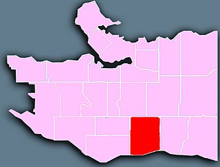
Riley Park–Little Mountain is a neighbourhood in Vancouver, British Columbia. Its boundaries are 41st Avenue to the south, 16th Avenue to the north, Cambie Street to the west, and Fraser Street to the east. The main commercial thoroughfare of the neighbourhood is Main Street.

Arbutus Ridge is an affluent residential neighbourhood in Vancouver's West Side. It is bordered by 16th Avenue in the north, 41st Avenue in the south, Mackenzie Street in the west, and East Boulevard in the east. The neighbourhood is characterized by larger than average lot sizes, with stately homes on tree-lined streets.
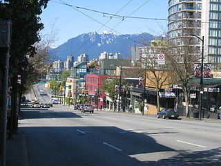
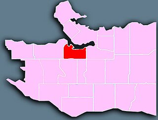
West Point Grey is a neighbourhood on the western side of the city of Vancouver, British Columbia, Canada. It is bordered by 16th Avenue to the south, Alma Street to the east, English Bay to the north, and Blanca Street to the west. Today, it's one of Canada's most expensive residential areas, with Point Grey average home prices sitting above the $3 million mark.
Fairview is a neighbourhood on the west side of the city of Vancouver, British Columbia, Canada. It runs from 16th Avenue in the south, to Burrard Street in the west, to Cambie Street in the east, and to False Creek in the north.
The Vancouver Hebrew Academy is a private orthodox Jewish pre-K to 7 school in Vancouver, British Columbia. The Vancouver Hebrew Academy is located at 1545 West 62nd Avenue in the Marpole neighbourhood.

Renfrew–Collingwood is a large neighbourhood that lies on the eastern side of Vancouver, British Columbia, Canada, on its boundary with Burnaby and encompassing an area that was one of the earlier developed regions of the city. It is a diverse area that includes a substantial business community in several areas, as well as some of the fastest-growing residential sectors of Vancouver. In 2011, the neighbourhood had a population of 50,500, 38.4% of whom claim Chinese as their first language.
Sunset is one of the most ethnically diverse neighbourhoods in south-east Vancouver, British Columbia.

Shaughnessy is an almost entirely residential neighbourhood in Vancouver, British Columbia, Canada, spanning about 447 hectares in a relatively central locale. It is bordered by 16th Avenue to the north, 41st Avenue to the south, Oak Street to the east, and East Boulevard to the west. The older section of the neighbourhood, called "First Shaughnessy," is considered more prestigious and is bordered by 16th Avenue to the north, King Edward Avenue to the south, Oak Street to the east, and East Boulevard to the west. In 2011, the population was approximately 8,807. It was named after Thomas Shaughnessy, 1st Baron Shaughnessy, former president of the Canadian Pacific Railway.

South Cambie is a neighbourhood in the city of Vancouver, British Columbia, Canada, that is generally considered one of the smallest neighbourhoods in the city, both in size and in population. It is wedged between one of the city's largest parks and the upscale neighbourhood of Shaughnessy, and is known for a large cluster of medical facilities.
Gambier Island is an island located in Howe Sound near Vancouver, British Columbia. It is about 17,049 acres in size and is located about 10 kilometres north of the Horseshoe Bay community and ferry terminal in westernmost West Vancouver.
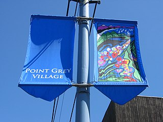
Point Grey is a headland marking the southern entrance to English Bay and Burrard Inlet. The headland is the site of Wreck Beach, Tower Beach, Point Grey Beach and most notably, since 1925, on its top is the Point Grey campus of the University of British Columbia.

The British Properties is a residential area in West Vancouver, British Columbia, Canada. The municipality of West Vancouver agreed to sell 4,000 acres to a syndicate controlled by the Guinness Brewing Company.
Stanley Park Neighbourhood is a neighbourhood of the West End in Vancouver, British Columbia, Canada. It is designated as the area lying between Denman Street and the boundary of Stanley Park proper. It is high density, like most of the West End, and is known for being a more affluent area of the West End and, once away from Denman Street, also one of the quietest on the downtown peninsula. Condominium properties facing the park are some of the most expensive in the city. The extreme southwest of the area overlaps with the English Bay Neighbourhood.
The English Bay Neighbourhood is a sub-area of the West End of Vancouver, British Columbia, Canada. Though not formally defined it is a common usage in the city and refers to the shopping and residential areas focussed on the intersection of Denman and Davie Streets with Beach Drive, at English Bay Beach. Generally the term refers to the first few blocks of residential areas flanking the beach from Stanley Park to Sunset Beach, and to the commercial area along Davie Street, and Denman Street south of Nelson Street.
Ambleside, West Vancouver, is a neighbourhood that occupies the southeastern corner of the community, with only Park Royal being farther east. The neighborhood is bordered by other neighbourhoods called Dundarave, Park Royal and the British Properties.
Dundarave is a neighbourhood in West Vancouver, British Columbia Canada. It occupies the central-eastern portion of West Vancouver's beachfront. It is bordered by Ambleside to the east and West Bay to the west.