The Arabian Sea is a region of the northern Indian Ocean bounded on the north by Pakistan and Iran, on the west by the Gulf of Aden, Guardafui Channel and the Arabian Peninsula, on the southeast by the Laccadive Sea, on the southwest by the Somali Sea, and on the east by India. Its total area is 3,862,000 km2 (1,491,000 sq mi) and its maximum depth is 4,652 metres (15,262 ft). The Gulf of Aden in the west, connects the Arabian Sea to the Red Sea through the strait of Bab-el-Mandeb, and the Gulf of Oman is in the northwest, connecting it to the Persian Gulf.

The Gulf of Oman or Sea of Oman is a strait that connects the Arabian Sea with the Strait of Hormuz, which then runs to the Persian Gulf. It borders Iran and Pakistan on the north, Oman on the south, and the United Arab Emirates on the west.
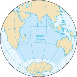
The Indian Ocean is the third largest of the world's oceanic divisions, covering 70,560,000 km2 (27,240,000 sq mi). It is bounded by Asia on the north, on the west by Africa, on the east by Australia, and on the south by the Southern Ocean or, depending on definition, by Antarctica.

The Arabian peninsula, simplified Arabia, is a peninsula of Western Asia situated northeast of Africa on the Arabian plate. From a geographical perspective, it is considered a subcontinent of Asia.

The Gulf of Aden, formerly known as the Gulf of Berbera, is a gulf amidst Yemen to the north, the Arabian Sea and Guardafui Channel to the east, Somalia to the south, and Djibouti to the west. In the northwest, it connects with the Red Sea through the Bab-el-Mandeb strait, and in the southeast, it connects with the Indian Ocean through the Guardafui Channel.
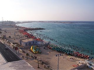
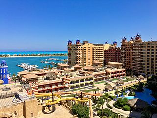
Mersa Matruh is a port in Egypt, capital of Matrouh Governorate. It is 240 km (150 mi) west of Alexandria and 222 km (138 mi) from Sallum on the main highway from the Nile Delta to the Libyan border. Another highway leads south from the town, toward the Western Desert and Siwa Oasis and Bahariya Oasis.
Arabian Gulf may refer to:

The Gulf of Aqaba or Gulf of Eilat is a large gulf at the northern tip of the Red Sea, east of the Sinai Peninsula and west of the Arabian mainland. Its coastline is divided between four countries: Egypt, Israel, Jordan, and Saudi Arabia.
Alexandria Governorate is one of the governorates of Egypt. The city of Alexandria was historically the capital of Egypt until the foundation of Fustat, which was later absorbed into Cairo. Today the Alexandria governorate is considered second in importance after the Cairo Governorate. It is located in the northern part of the country, directly on the Mediterranean Sea, making it one of the most important harbours in Egypt.
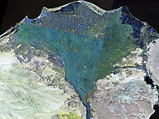
The Nile Delta is the delta formed in Northern Egypt where the Nile River spreads out and drains into the Mediterranean Sea. It is one of the world's largest river deltas—from Alexandria in the west to Port Said in the east, it covers 240 km (150 mi) of Mediterranean coastline and is a rich agricultural region. From north to south the delta is approximately 160 km (99 mi) in length. The Delta begins slightly down-river from Cairo.

The spice trade refers to the trade between historical civilizations in Asia, Northeast Africa and Europe. Spices such as cinnamon, cassia, cardamom, ginger, pepper, and turmeric were known and used in antiquity for commerce in the Eastern World. These spices found their way into the Middle East before the beginning of the Christian era, where the true sources of these spices were withheld by the traders and associated with fantastic tales. Early writings and stone age carvings of neolithic age obtained indicates that India's southwest coastal port Muziris, in Kerala, had established itself as a major spice trade centre from as early as 3000 BC, which marked the beginning of the spice trade. Kerala, referred to as the land of spices or as the "Spice Garden of India", was the place traders and explorers wanted to reach, including Christopher Columbus, Vasco da Gama, and others.

The Incense trade route included a network of major ancient land and sea trading routes linking the Mediterranean world with eastern and southern sources of incense, spices and other luxury goods, stretching from Mediterranean ports across the Levant and Egypt through Northeastern Africa and Arabia to India and beyond. The incense land trade from South Arabia to the Mediterranean flourished between roughly the 7th century BC and the 2nd century AD. The Incense trade route served as a channel for the trading of goods such as Arabian frankincense and myrrh; from Southeast Asia Indian spices, precious stones, pearls, ebony, silk and fine textiles; and from the Horn of Africa, rare woods, feathers, animal skins, Somali frankincense, and gold.

The Borg El Arab Stadium, sometimes referred to as El Geish Stadium - Borg El Arab, is a stadium commissioned in 2005 in the Mediterranean Sea resort of Borg El Arab; 25 km west of Alexandria, Egypt. It is the largest stadium in Egypt and the second largest in Africa with a capacity of 86,000 and is an all-seater. It is also the 27th largest stadium in the world, and the 9th largest association football stadium in the world. It is located on the Cairo-Alexandria desert highway 10 km from Borg El Arab Airport and 15 km from Alexandria's city center. A running track runs around the pitch, and the ground has four large floodlights. Only one stand is covered by a roof.

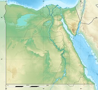
The northern coast of Egypt extends for about 1,050 km (650 mi) along the Mediterranean Sea from the eastern side of the Sinai Peninsula at the Egypt-Gaza border to the western village of Sallum at Egypt's border with Libya. It is one of the longest Mediterranean coastlines in North Africa.

Borg El Arab International Airport is an airport serving Alexandria, Egypt. It is located about 40 km (25 mi) southwest of Alexandria, in Borg El Arab. The airport also serves the nearby areas of the Nile Delta.
Khalij is an Arabic word meaning a "gulf" and may refer to:

The borders of the oceans are the limits of the Earth's oceanic waters. The definition and number of oceans can vary depending on the adopted criteria.
The 1969 Sharm El Sheikh earthquake occurred on March 31 off the southern Sinai peninsula in northeastern Egypt. The epicenter was located near Shadwan island, southwest of the city of Sharm El Sheikh, at the confluence of the Red Sea and the Gulf of Suez. This normal-slip shock measured 6.6 on the moment magnitude scale, had a maximum reported intensity of VII on the Mercalli intensity scale, and was responsible for several deaths and injuries.