Early history of the I-66 conflict
In the year 1956 the Virginia Highway Commission (later the Virginia Department of Transportation) proposed Interstate 66 to link Washington, D.C. to the planned Interstate 81, a total project length of 76 miles. The citizens of Arlington were concerned about the impacts of this project through their county, especially with regard to air quality, noise and community disruption. In 1971, ACT was the plaintiff in an action against the Virginia Highway Commission, having filed a suit in the U.S. district court. ACT won this case after a decision by the United States Court of Appeals for the Fourth Circuit, Arlington Coalition on Transportation v. Volpe, 458 F.2d 1323 (4th Cir.), cert. denied, 409 U.S. 1000 (1972). The court paid special attention to the plaintiff's expert calculations and testimony projecting that air quality levels would violate Federal ambient air quality standards as set forth in the Clean Air Act and violate United States Department of Housing and Urban Development guidelines for ambient noise.
The Washington Post , which paid little attention to the conflict, suddenly became a supporter of Arlington Coalition on Transportation after their stunning victory in the Fourth Circuit. Studies of air quality and noise continued under the direction of ESL Inc., who this time were working directly for the Virginia Department of Transportation under the agreement reached between plaintiff and defendant. These studies, part of the court-mandated environmental impact statement, led to further highway design mitigation, particularly related to acoustical impacts.
The conflict continued into the mid-1970s, until Secretary of Transportation William T. Coleman intervened to mediate the dispute and arrived at the "Coleman Decision," which amounted to a reduced four-lane highway with a Washington Metro element.
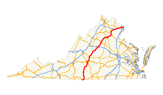
Interstate 66 (I-66) is an Interstate Highway in the eastern United States. As indicated by its even route number, it runs in an east–west direction. Its current western terminus is near Middletown, Virginia, at an interchange with I-81; its eastern terminus is in Washington, D.C., at an interchange with U.S. Route 29. Because of its terminus in the Shenandoah Valley, the highway was once called the "Shenandoah Freeway." Much of the route parallels U.S. Route 29 or Virginia State Route 55. Interstate 66 has no physical or historical connection to the famous U.S. Route 66 which is in a different region of the United States.

Interstate 73 (I-73) is a north–south Interstate Highway, located within the U.S. state of North Carolina. It is part of a longer planned corridor, defined by various federal laws to run from Myrtle Beach, South Carolina, to Sault Ste. Marie, Michigan, but only the part south of West Virginia is under study as of 2012. The corridor passes through the states of South Carolina, North Carolina, Virginia, West Virginia, Ohio, and Michigan. Ohio and Michigan do not plan to build any part of the highway, as the I-73 corridor in both of these states is already served by existing freeways or four-lane highways that will eventually be upgraded to freeways. West Virginia is building its section, mostly along U.S. Highway 52, as a four-lane divided highway, but not meeting the Interstate Highway standards. On the other hand, North Carolina and South Carolina have built sections and Virginia plans to build its part. Thus Interstate 73 will, once scheduled projects are completed, run from South Carolina to Roanoke, Virginia, where it will end at Interstate 81. Associated with these plans are those for the extension of Interstate 74 from Cincinnati to Myrtle Beach, with several highway overlaps contemplated.

The Orange Line is a rapid transit line of the Washington Metro system, consisting of 26 stations in Fairfax County and Arlington, Virginia; the District of Columbia; and Prince George's County, Maryland, United States. The Orange Line runs from Vienna in Virginia to New Carrollton in Maryland. Half of the line's stations are shared with the Blue Line and over two thirds are shared with the Silver Line. Orange Line service began on November 20, 1978.
Interstate 495 (I-495) is a 64-mile (103 km) Interstate Highway that surrounds Washington, D.C., the capital of the United States of America, and its inner suburbs in adjacent Maryland and Virginia. I-495 is widely known as the Capital Beltway, or simply the Beltway, especially when the context of Washington, D.C., is clear. It is the basis of the phrase "inside the Beltway", used when referring to issues dealing with American government and politics. I-95 utilizes the southern and eastern half of the Capital Beltway to circumnavigate Washington, D.C., and is cosigned with I-495 along that portion.
Interstate 395 (I-395) in Washington, D.C., and Virginia is a 13.39-mile-long (21.55 km) spur route of I-95 that begins at an interchange with I-95 in Springfield and ends at an interchange with U.S. Route 50 in northwest Washington, D.C. It passes underneath the National Mall near the U.S. Capitol and ends at a junction with US 50 at New York Avenue, roughly one mile (1.6 km) north of the 3rd Street Tunnel. Despite its proximity to I-395 in Maryland, the route is unrelated and unconnected.

State Route 244 is a primary state highway in the U.S. state of Virginia. Known as Columbia Pike, the state highway runs 8.25 miles (13.28 km) from SR 236 in Annandale east to SR 27 and Interstate 395 (I-395) at The Pentagon in Arlington. SR 244 is a major southwest–northeast thoroughfare in northeastern Fairfax County and eastern Arlington County, connecting Annandale with SR 7 at Bailey's Crossroads and SR 120 in the multicultural Westmont neighborhood of Arlington.
Corridor H of the Appalachian Development Highway System, also known as U.S. Route 48 (US 48), will extend 157 miles (253 km) from northern Virginia to central West Virginia. It is being constructed from Interstate 79 (I-79) in Weston eastward across the crest of the Allegheny Mountains to I-81 in Strasburg, Virginia.

The Appalachian Development Highway System (ADHS) is part of the Appalachian Regional Commission in the United States. It consists of a series of highway corridors in the Appalachia region of the eastern United States. The routes are designed as local and regional routes for improving economic development in the historically isolated region. It was established as part of the Appalachian Regional Development Act of 1965, and has been repeatedly supplemented by various federal and state legislative and regulatory actions. The system consists of a mixture of state, U.S., and Interstate routes. The routes are formally designated as "corridors" and assigned a letter. Signage of these corridors varies from place to place, but where signed are often done so with a distinctive blue-colored sign.

State Route 288 is a primary state highway in the U.S. state of Virginia. It is a freeway-standard partial beltway around the southwest side of Richmond. SR 288 was officially dedicated as the World War II Veterans Memorial Highway in 2004.

Transportation in the Commonwealth of Virginia is by land, sea and air. Virginia's extensive network of highways and railroads were developed and built over a period almost 400 years, beginning almost immediately after the founding of Jamestown in 1607, and often incorporating old established trails of the Native Americans.

Roadway air dispersion modeling is the study of air pollutant transport from a roadway or other linear emitter. Computer models are required to conduct this analysis, because of the complex variables involved, including vehicle emissions, vehicle speed, meteorology, and terrain geometry. Line source dispersion has been studied since at least the 1960s, when the regulatory framework in the United States began requiring quantitative analysis of the air pollution consequences of major roadway and airport projects. By the early 1970s this subset of atmospheric dispersion models were being applied to real world cases of highway planning, even including some controversial court cases.

Roadway noise is the collective sound energy emanating from motor vehicles. It consists chiefly of road surface, tire, engine/transmission, aerodynamic, and braking elements. Noise of rolling tires driving on pavement is found to be the biggest contributor of highway noise which increases with higher vehicle speeds.
U.S. Route 29 is a major north–south route in the Commonwealth of Virginia. It covers 248 miles (399 km) from the North Carolina border at the city of Danville to the Key Bridge in Washington, D.C.. US 29 roughly bisects Virginia into eastern and western halves, and along with Interstate 81 in western Virginia, and 85/95 farther east, provides one of the major north–south routes through the Commonwealth.

Boston Transportation Planning Review (BTPR), published in 1972, was a transportation planning program for metropolitan Boston, Massachusetts, which was responsible for analyzing and redesigning the entire area-wide transit and highway system in the 1970s. The major contractors involved were Alan M. Voorhees Company (Virginia), project manager; Skidmore, Owings and Merrill, architect; ESL Incorporated (California), air quality and acoustics. The program had close guidance from the national Transportation Research Board (TRB), a division of the US National Academy of Sciences. The first director of the program reporting to the Governor was Alan Altshuler; the project manager was Walter Hansen.
This article deals with the streets and highways of Arlington County, Virginia, a suburb of Washington, D.C. in the United States.
Interstate 66 (I-66) was a proposed Interstate Highway designated in the Intermodal Surface Transportation Efficiency Act (ISTEA) of 1991 as the East–West TransAmerica Corridor and High Priority Corridor 3. The United States Department of Transportation originally planned to extend the current I-66 from its western terminus at Middletown, Virginia, across the country to California. The route west of Kansas was not favored by any of the related state highway departments, and as a result I-66 west of Wichita, Kansas, through New Mexico, Arizona, Nevada and California was cancelled. Among the reasons for this were lack of interest from any of the state highway departments, and the insufficient projected traffic did not justify an Interstate, especially since many segments had no pre-existing highway. The National Park Service was strongly opposed to building I-66 across the Death Valley National Park. The choice for the number I-66 was a hope to capitalize on name association with the decommissioned U.S. Route 66 (US 66). The case for westward expansion of I-66 was started by businesspeople in Wichita. Furthermore, there were no plans to build I-66 across the West Virginia–Virginia state line, leaving it as a non-contiguous highway. The I-66 concept was supported in Kentucky mainly because of the efforts of Congressman Hal Rogers, however the Kentucky Transportation Cabinet completed its feasibility study in 2005 and concluded that building I-66 was too costly and of little traffic benefit with high potential environmental impact and cancelled the project in that state. The only remaining study of I-66 was conducted by the Federal Highway Administration (FHWA) and the Illinois Department of Transportation (IDOT) under the 66 Corridor Study, a Tier 1 environmental impact study (EIS). This study was cancelled August 6, 2015, by IDOT, and subsequently the FHWA announced the cancellation of the EIS in the Federal Register, ending the last I-66 project and therefore officially cancelling the I-66 Trans America Highway.
Interstate 73 (I-73) is a planned Interstate Highway in Virginia. Authorized by the Intermodal Surface Transportation Efficiency Act of 1991 (ISTEA), Virginia's section would begin at the North Carolina state line and follow the U.S. Route 220 corridor through Martinsville and Roanoke, then westerly into West Virginia, possibly along Corridor Q. Since its inception, environmental studies have been completed; but because it scores low for project jobs in the state, the Virginia Department of Transportation (VDOT) has shelved plans for the foreseeable future.
Interstate 87 (I-87) is a partially completed Interstate Highway in the U.S. state of North Carolina, currently the shortest designated primary interstate highway at 12.9 miles (20.8 km). The completed portion is in eastern Wake County, between Raleigh and Wendell; the majority of the completed route is known as the Knightdale Bypass, while the remaining 3 miles (4.8 km) follows the Raleigh Beltline. It is planned to continue northeast through Rocky Mount, Williamston and Elizabeth City, ending in Norfolk, Virginia. It is not contiguous with Interstate 87 in New York. It is signed as north-south, in keeping with the sign convention for most odd-numbered interstates, but the route goes primarily east-west, with the eastern direction aligning to the north designation.

The Three Sisters Bridge was a planned bridge over the Potomac River in Washington, D.C., with piers on the Three Sisters islets. Envisioned in the 1950s and formally proposed in the 1960s, it was cancelled amid protests in the 1970s.
The Northern Virginia region is served by numerous mediums of transit. Transportation in the region is overseen by the Northern Virginia Transportation Commission and the Northern Virginia Transportation Authority.