An archipelago, sometimes called an island group or island chain, is a chain, cluster or collection of islands, or sometimes a sea containing a small number of scattered islands.

The Azores, officially the Autonomous Region of the Azores, is one of the two autonomous regions of Portugal. It is an archipelago composed of nine volcanic islands in the North Atlantic Ocean about 1,360 km (850 mi) west of continental Portugal, about 1,643 km (1,021 mi) west of Lisbon, in continental Portugal, about 1,507 km (936 mi) northwest of Morocco, and about 1,925 km (1,196 mi) southeast of Newfoundland, Canada.

The Bahamas, known officially as the Commonwealth of The Bahamas, is a country within the Lucayan Archipelago. The archipelagic state consists of more than 700 islands, cays, and islets in the Atlantic Ocean, and is located north of Cuba and Hispaniola, northwest of the Turks and Caicos Islands, southeast of the U.S. state of Florida, and east of the Florida Keys. The capital is Nassau on the island of New Providence. The designation of "the Bahamas" can refer either to the country or to the larger island chain that it shares with the Turks and Caicos Islands. The Royal Bahamas Defence Force describes the Bahamas territory as encompassing 470,000 km2 (180,000 sq mi) of ocean space.

Lake Michigan is one of the five Great Lakes of North America and the only one located entirely within the United States. The other four Great Lakes are shared by the U.S. and Canada. It is the second-largest of the Great Lakes by volume and the third-largest by surface area, after Lake Superior and Lake Huron. To the east, its basin is conjoined with that of Lake Huron through the wide Straits of Mackinac, giving it the same surface elevation as its easterly counterpart; the two are technically a single lake.

The Marshall Islands, officially the Republic of the Marshall Islands, is an island country and a United States associated state near the equator in the Pacific Ocean, slightly west of the International Date Line. Geographically, the country is part of the larger island group of Micronesia. The country's population of 53,158 people is spread out over 29 coral atolls, comprising 1,156 individual islands and islets.

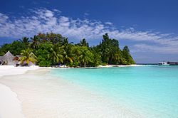
Mauritius, officially the Republic of Mauritius, is an island nation in the Indian Ocean. The main Island of Mauritius is located about 2,000 kilometres (1,200 mi) off the southeast coast of the African continent. The Republic of Mauritius also includes the islands of Rodrigues, Agalega and St. Brandon. The capital and largest city Port Louis is located on the main island of Mauritius.

Rhode Island, officially the State of Rhode Island and Providence Plantations, is a state in the New England region of the United States. It is the smallest state in area, the seventh least populous, and the second most densely populated, but it has the longest official name of any state. Rhode Island is bordered by Connecticut to the west, Massachusetts to the north and east, and the Atlantic Ocean to the south via Rhode Island Sound and Block Island Sound. It also shares a small maritime border with New York. Providence is the state capital and most populous city in Rhode Island.

South Georgia and the South Sandwich Islands (SGSSI) is a British Overseas Territory in the southern Atlantic Ocean. It is a remote and inhospitable collection of islands, consisting of South Georgia and a chain of smaller islands known as the South Sandwich Islands. South Georgia is 165 km (103 mi) long and 35 km (22 mi) wide and is by far the largest island in the territory. The South Sandwich Islands lie about 700 km (430 mi) southeast of South Georgia. The territory's total land area is 3,903 km2 (1,507 sq mi). The Falkland Islands are about 1,300 km (810 mi) north-west from its nearest point.

The Statue of Liberty is a colossal neoclassical sculpture on Liberty Island in New York Harbor in New York, in the United States. The copper statue, a gift from the people of France to the people of the United States, was designed by French sculptor Frédéric Auguste Bartholdi and its metal framework was built by Gustave Eiffel. The statue was dedicated on October 28, 1886.

Easter Island is a Chilean island in the southeastern Pacific Ocean, at the southeasternmost point of the Polynesian Triangle in Oceania. Easter Island is most famous for its nearly 1,000 extant monumental statues, called moai, created by the early Rapa Nui people. In 1995, UNESCO named Easter Island a World Heritage Site, with much of the island protected within Rapa Nui National Park.
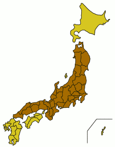
Honshu is the largest and most populous island of Japan, located south of Hokkaido across the Tsugaru Strait, north of Shikoku across the Inland Sea, and northeast of Kyushu across the Kanmon Straits. The island separates the Sea of Japan, which lies to its north and west, from the North Pacific Ocean to its south and east. It is the seventh-largest island in the world, and the second-most populous after the Indonesian island of Java.

Hawaiʻi is the largest island located in the U.S. state of Hawaii. It is the largest and the southeasternmost of the Hawaiian Islands, a chain of volcanic islands in the North Pacific Ocean. With an area of 4,028 square miles (10,430 km2), it has 63% of the Hawaiian archipelago's combined landmass, and is the largest island in the United States. However, it has only 13% of Hawaiʻi's people. The island of Hawaiʻi is the third largest island in Polynesia, behind the two main islands of New Zealand.

Réunion is an overseas department and region of France and an island in the Indian Ocean, east of Madagascar and 175 km (109 mi) southwest of Mauritius. As of January 2019, it had a population of 866,506.
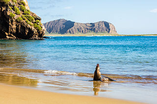
The Galápagos Islands, part of the Republic of Ecuador, are an archipelago of volcanic islands distributed on either side of the equator in the Pacific Ocean surrounding the centre of the Western Hemisphere, 906 km (563 mi) west of continental Ecuador. The islands are known for their large number of endemic species and were studied by Charles Darwin during the second voyage of HMS Beagle. His observations and collections contributed to the inception of Darwin's theory of evolution by means of natural selection.

Iwo To, known in English as Iwo Jima, is one of the Japanese Volcano Islands and lies south of the Bonin Islands. Together with other islands, they form the Ogasawara Archipelago. The highest point of Iwo Jima is Mount Suribachi at 161 m (528 ft) high.

The Eastern Time Zone (ET) is a time zone encompassing part or all of 22 states in the eastern part of the contiguous United States, parts of eastern Canada, the state of Quintana Roo in Mexico, Panama in Central America, and the Caribbean Islands.
In topography, prominence measures the height of a mountain or hill's summit relative to the lowest contour line encircling it but containing no higher summit within it. It is a measure of the independence of a summit. A peak's key col is a unique point on this contour line and the parent peak is some higher mountain, selected according to various objective criteria.

The 2004 Indian Ocean earthquake occurred at 00:58:53 UTC on 26 December, with an epicentre off the west coast of northern Sumatra. It was an undersea megathrust earthquake that registered a magnitude of 9.1–9.3 Mw, reaching a Mercalli intensity up to IX in certain areas. The earthquake was caused by a rupture along the fault between the Burma Plate and the Indian Plate.

American Samoa is an unincorporated territory of the United States located in the South Pacific Ocean, southeast of Samoa. Its location is centered around 14.2710° S, 170.1322° W. It is on the eastern border of the International Date Line, while independent Samoa is west of it.
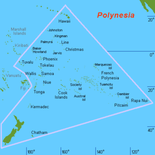
Polynesia is a subregion of Oceania, made up of more than 1,000 islands scattered over the central and southern Pacific Ocean. The indigenous people who inhabit the islands of Polynesia are termed Polynesians, and share many similar traits including language family, culture, and beliefs. Historically, they had a strong tradition of sailing and using stars to navigate at night. The largest country in Polynesia is New Zealand.