Batnfjordsøra

Last updated
Batnfjordsøra
Village

Batnfjorden-Gjemnes-Batnfjordsora.jpg

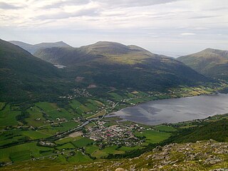
Batnfjordsøra at the end of the Batnfjorden
Norway More og Romsdal location map.svg
Red pog.svg
Batnfjordsøra
Location in Møre og Romsdal
Norway location map.svg
Red pog.svg
Batnfjordsøra
Batnfjordsøra (Norway)
Coordinates: 62°53′33″N07°40′54″E / 62.89250°N 7.68167°E / 62.89250; 7.68167 Coordinates: 62°53′33″N07°40′54″E / 62.89250°N 7.68167°E / 62.89250; 7.68167
Country Norway
Region Western Norway
County Møre og Romsdal
District Nordmøre
Municipality Gjemnes Municipality
Area [1]
  Total 0.32 km2 (0.12 sq mi)
Elevation [2] 16 m (52 ft)
Population (2013) [1]
  Total 319
  Density 997/km2 (2,580/sq mi)
Time zone CET (UTC+01:00)
  Summer (DST) CEST (UTC+02:00)
Post Code6631 Batnfjordsøra

Batnfjordsøra is the administrative centre of Gjemnes Municipality in Møre og Romsdal county, Norway. The village is located at the end of the Batnfjorden at the mouth of the river Batnfjordelva. European Route E39 passes through the village on its way from Molde to Trondheim. The 0.32-square-kilometre (79-acre) village has a population (2013) of 319, which gives the village a population density of 997 inhabitants per square kilometre (2,580/sq mi). [1]

An administrative centre is a seat of regional administration or local government, or a county town, or the place where the central administration of a commune is located.

Møre og Romsdal County (fylke) of Norway

Møre og RomsdalUrban East Norwegian: [²møːrə ɔ ˈrʊmsdɑːl](listen) is a county in the northernmost part of Western Norway. It borders the counties of Trøndelag, Oppland and Sogn og Fjordane. The county administration is located in the town of Molde, while Ålesund is the largest town. The county is governed by the Møre og Romsdal County Municipality which includes an elected county council and a county mayor. The national government is represented by the county governor.

Norway constitutional monarchy in Northern Europe

Norway, officially the Kingdom of Norway, is a Nordic country in Northwestern Europe whose territory comprises the western and northernmost portion of the Scandinavian Peninsula; the remote island of Jan Mayen and the archipelago of Svalbard are also part of the Kingdom of Norway. The Antarctic Peter I Island and the sub-Antarctic Bouvet Island are dependent territories and thus not considered part of the kingdom. Norway also lays claim to a section of Antarctica known as Queen Maud Land.

The village of Gjemnes lies about 8 kilometres (5.0 mi) to the northeast, along the north side of the fjord, and Torvikbukt lies about 10 kilometres (6.2 mi) to the northeast along the south side of the fjord. The village of Øre lies about halfway between Torvikbukt and Batnfjordsøra. Heading southwest along E39, you will get to Hjelset and Molde.

Gjemnes (village) Village in Western Norway, Norway

Gjemnes is a village in Gjemnes Municipality in Møre og Romsdal county, Norway. The village is located on the southern part of a small peninsula surrounded by the Kvernesfjorden to the north and the Batnfjorden to the south. The village sits along the European route E39 at the western end of the Gjemnessund Bridge (which is part of the network of bridges and tunnels that connect the town of Kristiansund to the mainland. The municipal centre of Batnfjordsøra lies about 8 kilometres to the southwest, at the end of the fjord.

Torvikbukt Village in Western Norway, Norway

Torvikbukt is a village in Gjemnes Municipality in Møre og Romsdal county, Norway. The village is located at the junction of the Batnfjorden and Tingvollfjorden and just northwest of the 994-metre (3,261 ft) tall mountain Reinsfjellet. The village of Øre lies about 6 kilometres (3.7 mi) to the southwest and Heggem lies about 9 kilometres (5.6 mi) to the south. The 0.39-square-kilometre (96-acre) village has a population (2013) of 226, which gives the village a population density of 579 inhabitants per square kilometre (1,500/sq mi).

Øre, Norway Former Municipality

Øre is a village and former municipality in Møre og Romsdal county, Norway. The village is located along the Batnfjorden in the present-day Gjemnes Municipality. The village lies about half-way between the villages of Batnfjordsøra and Torvikbukt. Øre Church is located in this village. The village of Øre was the administrative centre of the old Øre Municipality which existed from 1838 until 1965.

Related Research Articles

Midsund Municipality in Møre og Romsdal, Norway

Midsund is a municipality in Møre og Romsdal county, Norway. It is part of the Romsdal region. The administrative centre is the village of Midsund on Otrøya island. Other settlements on the island include Uglvik and Raknes in the north and Nord-Heggdal in the southeast.

Angvik Village in Western Norway, Norway

Angvik or Angvika is a small village in Gjemnes Municipality in Møre og Romsdal county, Norway. The village is located along the western shores of the Tingvollfjorden, just across the fjord from the village of Tingvollvågen.

Rausand Village in Western Norway, Norway

Raudsand or Rausand is a village in Nesset Municipality in Møre og Romsdal county, Norway. It is located on the Romsdal peninsula along the Tingvollfjorden about 9 kilometres (5.6 mi) northeast of the village of Eidsvåg and 8 kilometres (5.0 mi) south of the village of Angvika in Gjemnes Municipality. The 0.45-square-kilometre (110-acre) village has a population (2013) of 277, which gives the village a population density of 616 inhabitants per square kilometre (1,600/sq mi).

Kvernesfjord

Kvernesfjorden or Kvernesfjord is a fjord between the municipalities of Gjemnes, Kristiansund, Averøy, and Eide in Møre og Romsdal county, Norway. The fjord is about 22 kilometres (14 mi) long.

Batnfjord fjord in Gjemnes, Norway

Batnfjord or Batnfjorden is a fjord in Gjemnes Municipality in Møre og Romsdal county, Norway. The 10-kilometre (6.2 mi) long fjord begins at the village of Batnfjordsøra, the municipal center of Gjemnes Municipality, and runs to the northeast toward the island of Bergsøya, where it joins the Tingvollfjorden. Other villages on the shores of the fjord include Gjemnes, Torvikbukt, and Øre. The European route E39 highway runs along the northern shore of the fjord. The Batnfjordelva flows into this fjord.

Romsdalshalvøya

Romsdalshalvøya, sometimes translated as the Romsdal Peninsula is a 1,560-square-kilometre (600 sq mi) peninsula located in the Romsdal district of Møre og Romsdal county in Norway. The peninsula encompasses the western Norwegian municipalities of Molde, Gjemnes, Fræna, Eide, and the northern part of Nesset.

Etnesjøen Village in Western Norway, Norway

Etnesjøen or Etne is the administrative centre of Etne municipality in Hordaland county, Norway. The village is located at the inner end of the Etnefjorden, along the European route E134 highway, about 8 kilometres (5.0 mi) south of the village of Skånevik and about 10 kilometres (6.2 mi) northeast of the village of Ølensjøen.

Stanghelle Village in Western Norway, Norway

Stanghelle is a village in Vaksdal municipality in Hordaland county, Norway. The village lies along the Veafjorden at the mouth of the Hellestraumen. The 0.4-square-kilometre (99-acre) village has a population (2013) of 783, giving the village a population density of 1,958 inhabitants per square kilometre (5,070/sq mi).

Reinsfjellet mountain in Norway

Reinsfjellet is a mountain in Gjemnes Municipality in Møre og Romsdal county, Norway. The 994-metre (3,261 ft) tall mountain is the third tallest mountain in the municipality. It is located on the Romsdal peninsula about 4 kilometres (2.5 mi) southeast of the village of Torvikbukt and the Batnfjorden. The village of Heggem lies 6.5 kilometres (4.0 mi) to the southwest and Angvika lies 10 kilometres (6.2 mi) to the southeast.

Vikøyri Village in Western Norway, Norway

Vikøyri is the administrative center of the municipality of Vik in Sogn og Fjordane county, Norway. The village is located at the mouth of the Vikja river on the south shore of the Sognefjorden, roughly near the midpoint of Norway's longest fjord. The village lies along Norwegian National Road 13 which leads north to the ferry to Balestrand and south to the village of Vossevangen. The 1.26 square kilometres village of Vikøyri has a population (2013) of 1,195; giving the village a population density of 948 inhabitants per square kilometre (2,460/sq mi).

Hjelset Village in Western Norway, Norway

Hjelset is a village in Molde Municipality in Møre og Romsdal county, Norway. It is located on the north shore of the Fannefjorden, about 8 kilometres (5.0 mi) west of Kleive and about 16 kilometres (9.9 mi) east of the town of Molde. The European route E39 highway runs through the village on its way northeast from the town of Molde to Batnfjordsøra in Gjemnes Municipality. The 0.86-square-kilometre (210-acre) village has a population (2013) of 1,037 which gives the village a population density of 1,206 inhabitants per square kilometre (3,120/sq mi).

Tingvollfjorden (Møre og Romsdal) fjord in Møre og Romsdal, Norway

Tingvollfjorden is a fjord in the municipalities of Tingvoll, Gjemnes, Nesset, and Sunndal. The 17 kilometres (11 mi) long inner part of the fjord is called the Sunndalsfjorden. The fjord begins at the island of Bergsøya and stretches about 52 kilometres (32 mi) to the village of Sunndalsøra. The river Driva flows into the fjord at its end. The fjord reaches a depth of 365 metres (1,198 ft) below sea level. Villages along the fjord include Torvikbukt, Flemma, Angvika, Tingvollvågen, Rausand, Jordalsgrenda, Øksendalsøra, Hoem, and Sunndalsøra.

Batnfjordelva

Batnfjordelva is a river in Gjemnes Municipality in Møre og Romsdal county, Norway. It originates from the lake Botnvatnet and it flows to the east and later northeast until it empties into the Batnfjorden at the village of Batnfjordsøra. The river is 19.6 kilometres (12.2 mi) long and it has a catchment of 70 square kilometres (27 sq mi). The discharge rate at the mouth of the river is 4.61 cubic metres per second (163 cu ft/s).

Vestnes (village) Village in Western Norway, Norway

Vestnes is the administrative centre of Vestnes Municipality in Møre og Romsdal county, Norway. The village is located on the western shore of the Tresfjorden, near where the fjord empties into the main Romsdal Fjord. The village lies along the European route E39 highway. The 1.87-square-kilometre (460-acre) village has a population (2013) of 2,241 which gives the village a population density of 1,198 inhabitants per square kilometre (3,100/sq mi), and making it the largest settlement in the whole municipality.

Tingvollvågen Village in Western Norway, Norway

Tingvollvågen or Tingvoll is the administrative centre of Tingvoll Municipality in Møre og Romsdal county, Norway. The village is located on a small inlet off the Tingvollfjorden, directly across the fjord from the village of Angvika. Tingvollvågen lies about 10 kilometres (6.2 mi) north of Meisingset and about 20 kilometres (12 mi) south of Straumsnes. The historic Tingvoll Church is located in this village. Norwegian National Road 70 runs through the village on its way from Kristiansund to Oppdal.

Røbekk Village in Western Norway, Norway

Røbekk is a village in Molde Municipality in Møre og Romsdal county, Norway. The village is located on the northern shore of the Fannefjorden, about 7 kilometres (4.3 mi) east of the town of Molde. The Årø neighborhood lies immediately to the west of Røbekk. The European route E39 highway runs through the village on its way from the town of Molde towards Batnfjordsøra in Gjemnes Municipality. Røbekk Church has been located in this village since 1898.

References