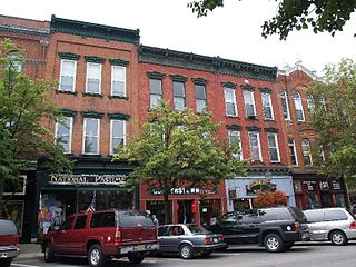
Cooperstown is a village in and county seat of Otsego County, New York, United States. Most of the village lies within the town of Otsego, but some of the eastern part is in the town of Middlefield. It is located in the Central New York Region of New York.
Horton is a hamlet in the parish of Ivinghoe, in Buckinghamshire, England. It is in the civil parish of Slapton.

Coombe is a place in the London Borough of Croydon, not far from central Croydon.

Blandair, also known as Blandair Farm, Blandair Park, and Blandair Regional Park, is 300 acres of former slave plantation located in Columbia, Maryland. The Blandair Foundation estate of Mrs. Smith was purchased by Howard County, Maryland in the late 1990s and is in the process of being developed as a regional park.

Vaynol or Y Faenol is a country estate dating from the Tudor period near Y Felinheli in Gwynedd, North Wales. It comprises 1,000 acres (4.0 km2) of park, farmland, and gardens on the estate, with more than thirty listed buildings, surrounded by a wall which is 7 miles (11 km) long. "Y Faenol" means "the manor" and is a mutated form of the Welsh word maenol.

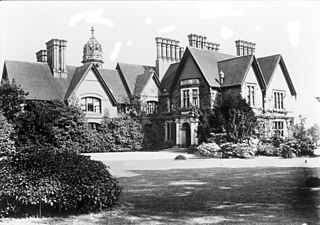
The Moor Hall is a 1905 house, built for Colonel Edward Ansell of Ansells Brewery, in Sutton Coldfield, Birmingham, England. It has been used as a hotel since 1930 and subsequently extended. It is on the site of a former 15th century building.

Château Gruaud-Larose is a winery in the Saint-Julien appellation of the Bordeaux region of France. It is also the name of the red wine produced by this property. The wine produced here was classified as one of fifteen Deuxièmes Crus in the original Bordeaux Wine Official Classification of 1855.

Witley Park, formerly known as Lea Park, is an estate dating from the 19th-century between Godalming and Haslemere, Surrey, England. Its landscaped grounds include three artificial lakes, one of which conceals a remarkable underwater conservatory and smoking room.
Darby Dan Farm is a produce, livestock, and thoroughbred horse breeding and training farm founded in 1935 near the Darby Creek in Galloway, Ohio by businessman John W. Galbreath. Named for the creek and for Galbreath's son, Daniel M. Galbreath (1928-1995), it was expanded from an original 85-acre (340,000 m2) farm into a 4,000 acre (16 km²) estate. Established in 1954 on the original area, Darby House today serves as a banquet and retreat facility. Still in the hands of the Galbreath family, it has 250 acres (1 km²) of woodlands, a 110-acre (0.4 km2) animal preserve, and approximately 3000 acres (12 km²) used for the commercial growing of food crops. The horse farm has 750 acres (3 km²) of blue grass pasture plus a large number of barns and breeding facilities. As well, 39 houses were built on the property.

Dundas Castle is a 15th-century castle, with substantial 19th-century additions by William Burn, in the Dalmeny parish of West Lothian, Scotland. The home of the Dundas family since the Middle Ages, it was sold in the late 19th century and is currently the residence of politician and businessman Sir Jack Stewart-Clark.

Norbury Manor is a 15th-century Elizabethan manor house and the adjoining 13th-century stone-built medieval Norbury Hall, known as The Old Manor in Norbury near Ashbourne, Derbyshire. It is a Grade I listed building.
Wynnstay is a country house located in an important landscaped park 1.3 km south-east of Ruabon, near Wrexham, Wales. Wynnstay, previously Watstay, was a famous estate and the family seat of the Wynns.

The Berry Mansion was built in Frankfort, Kentucky, in 1900 by George Franklin Berry. It is located on a hill just west of downtown that overlooks the state capitol building.

Brownsover Hall is a 19th-century mansion house in the old village of Brownsover, Rugby, Warwickshire which has been converted for use as a hotel. It is a Grade II* listed building.

Hollindale is an unincorporated community in Fort Hunt, Fairfax County, Virginia, United States close to the George Washington Memorial Parkway in ZIP code 22306. As of 2013, it had 945 residents. Mount Vernon Presbyterian Church and Hollin Meadows Elementary School are located within the community. Hollindale is set along the hilly woodlands across from the Potomac. It was built around several estates and on what used to be Sherwood Dairy Farm, and is adjacent to the Hollin Hills community. It is dominated by mid-century modern homes, colonials, and Tudors.
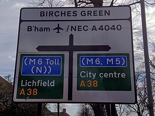
Birches Green is a small area of Tyburn in Birmingham, England. It is located between Gravelly Hill and Bromford.

Brightholmlee is a small rural hamlet situated within the City of Sheffield in England. The hamlet falls within the Stannington Ward of the City. It is located 6.2 miles (10 km) north-west of the city centre and 0.6 miles (1 km) west of Wharncliffe Side within Bradfield Parish. Previously a farming community, it consist of four farmsteads, Manor Farm, Old Hall Farm, High Lea Farm and Lee Farm. It is now almost entirely residential with the last working farm being sold for development in 2013.
Ward Acres is a 62-acre park in the Wykagyl section of the city of New Rochelle, in Westchester County, New York. Formerly part of a large country estate and horse farm, New Rochelle purchased the land in 1962 with help from the New York State Park and Recreation Land Acquisition Bond Act.