Bishia

Last updated

Bishia (Arabic : نشيا) is a small locality in western Eritrea.

Eritrea country in the Horn of Africa

Eritrea, officially the State of Eritrea is a country in the Horn of Africa, with its capital at Asmara. It is bordered by Sudan in the west, Ethiopia in the south, and Djibouti in the southeast. The northeastern and eastern parts of Eritrea have an extensive coastline along the Red Sea. The nation has a total area of approximately 117,600 km2 (45,406 sq mi), and includes the Dahlak Archipelago and several of the Hanish Islands. Its toponym Eritrea is based on the Greek name for the Red Sea, which was first adopted for Italian Eritrea in 1890.

Contents

Transport

It is the end of the Eritrean Railway line from Asmara, though the line did briefly extend through to Sudan. However the railway no longer extends here, having been damaged during the Eritrean-Ethiopian War. The railway has been rehabilitated between the Red Sea and Asmara but has not been rebuilt up to Bishia.

Eritrean Railway

The Eritrean Railway is the only railway system in Eritrea. It was constructed between 1887 and 1932 by the Kingdom of Italy for the Italian Eritrea colony and connected the port of Massawa with Asmara and Bishia near the Sudan border. The line was destroyed by warfare in subsequent decades, but has been rebuilt between Massawa and Asmara. Vintage equipment is still used on the line.

Asmara Capital in Maekel, Eritrea

Asmara ( əs-MAHR}; or Asmera, is the capital and most populous city of Eritrea and the Central Region. It sits at an elevation of 2,325 metres, making it the sixth highest capital in the world by altitude. The city is located at the tip of an escarpment that is both the northwestern edge of the Eritrean highlands and the Great Rift Valley in neighbouring Ethiopia. In 2017, the city was declared as a UNESCO World Heritage Site for its well-preserved modernist architecture. Asmara was first settled in 800 BC with a population ranging from 100 to 1000. The city was then founded in the 12th century CE after four separate villages unified to live together peacefully after long periods of conflict.

Sudan country in Northeast Africa

Sudan or the Sudan, officially the Republic of the Sudan, is a country in Northeast Africa. It is bordered by Egypt to the north, the Red Sea to the northeast, Eritrea to the east, Ethiopia to the southeast, South Sudan to the south, the Central African Republic to the southwest, Chad to the west, and Libya to the northwest. It houses 37 million people (2017) and occupies a total area of 1,861,484 square kilometres, making it the third-largest country in Africa. Sudan's predominant religion is Islam, and its official languages are Arabic and English. The capital is Khartoum, located at the confluence of the Blue and White Nile.

See also

Related Research Articles

Transport in Eritrea

Transport in Eritrea includes highways, airports and seaports, in addition to various forms of public and private vehicular, maritime and aerial transportation.

Massawa City in Northern Red Sea, Eritrea

Massawa is a city on the Red Sea coast of Eritrea located at the northern end of the Gulf of Zula beside the Dahlak Archipelago. As a historical and important port for many centuries, it was ruled by a succession of polities, including the Axumite Empire, Medri Bahri Kingdom, the Umayyad Caliphate, various Beja sultanates, the Ottoman Empire, the Khedivate of Egypt, Italy, Britain, and Ethiopia, until Eritrea's independence in 1991. Massawa was the capital of the Italian Colony of Eritrea until it was moved to Asmara in 1897.

Asmara-Massawa Cableway Aerial lift in Asmara, Eritrea

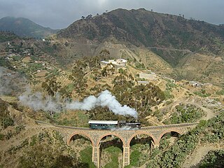
The Asmara-Massawa Cableway was a cableway built in Italian Eritrea before World War II.The Eritrean Ropeway, completed in 1937, ran 71.8 km from the south end of Asmara until the city-port of Massawa.

Kassala Place in Kassala State, Sudan

Kassala is the capital of the state of Kassala in eastern Sudan. Its 2008 population was recorded to be 419,030. Built on the banks of the Gash River, it is a market town and is famous for its fruit gardens.

Mareb River river

The Mareb River, is a river flowing out of central Eritrea. Its chief importance is defining part of the boundary between Eritrea and Ethiopia, between the point where the Mai Ambassa enters the river at 14°53.6′N37°54.8′E to the confluence of the Balasa with the Mareb at 14°38′N39°1.3′E.

Agordat Town in Gash-Barka, Eritrea

Agordat is a city in Gash-Barka, Eritrea. It was the capital of the former Barka province, which was situated between the present-day Gash-Barka and Anseba regions.

Hamasien was a historical province including and surrounding Asmara, part of modern Eritrea. In 1996 the province was divided and distributed amongst the modern Maekel, Debub, Northern Red Sea, Gash-Barka, and Anseba regions.

Fiat Tagliero Building gas station

The Fiat Tagliero Building in Asmara, capital city of Eritrea, is a Futurist-style service station completed in 1938 and designed by the Italian engineer Giuseppe Pettazzi.

Cinema Impero cinema in Asmara, Eritrea

The Cinema Impero is an Art Deco-style cinema in Asmara, the capital of Eritrea. It was built in 1937 by the colonial authorities in Italian Eritrea.

Governors Palace, Asmara

The Governor's Palace is the city hall of Asmara, Eritrea. It was built during the colonial period in the city centre, in an Italian Art-Deco style.

Articles related to Eritrea include:

Nefasit Town in Northern Red Sea, Eritrea

Nefasit, also known as Tappa Nefasit, is a small town in the Northern Red Sea Region of Eritrea. Monastery of Debre Bizen is located at the mountains above.

Massawa Subregion is a subregion in the Northern Red Sea region of Eritrea. Its capital lies at Massawa.

Asmara Presidents Office

The Asmara President's Office is the building, in Italian neoclassical style, where the President of Eritrea lives and rules the country.

Italian Eritrea Italian 1890-1947 possession in East Africa

Italian Eritrea was a colony of the Kingdom of Italy in the territory of present-day Eritrea. Although it was formally created in 1890, the first Italian settlements in the area were established in 1882 around Assab. The colony officially lasted until 1947.

Asmaras Opera theatre and cinema in Asmara, Eritrea

Asmara's Opera is an opera theater in Asmara, Eritrea. It was constructed in 1918 following a design by the Italian architect Odoardo Cavagnari, with later renovations in 1936.

References

    Coordinates: 15°29′02″N37°32′41″E / 15.48389°N 37.54472°E / 15.48389; 37.54472

    Geographic coordinate system Coordinate system

    A geographic coordinate system is a coordinate system that enables every location on Earth to be specified by a set of numbers, letters or symbols. The coordinates are often chosen such that one of the numbers represents a vertical position and two or three of the numbers represent a horizontal position; alternatively, a geographic position may be expressed in a combined three-dimensional Cartesian vector. A common choice of coordinates is latitude, longitude and elevation. To specify a location on a plane requires a map projection.