Blue Cross & Blue Shield of Rhode Island Headquarters

Last updated
Blue Cross and Blue Shield of Rhode Island Headquarters
Blue Cross Blue Shield building, Providence RI.jpg
General information
Location Providence, RI 02903, United States
Construction started2008
Completed2009
Height
Roof237 ft (72 m)
Technical details
Floor count13
Floor area325,000 sq ft (30,200 m2)
Design and construction
ArchitectSymmes Maini & McKee Associates

The Blue Cross & Blue Shield of Rhode Island Headquarters is a LEED Certified high-rise in downtown Providence, Rhode Island. [1]

Providence, Rhode Island Capital of Rhode Island

Providence is the capital and most populous city of the U.S. state of Rhode Island and is one of the oldest cities in the United States. It was founded in 1636 by Roger Williams, a Reformed Baptist theologian and religious exile from the Massachusetts Bay Colony. He named the area in honor of "God's merciful Providence" which he believed was responsible for revealing such a haven for him and his followers. The city is situated at the mouth of the Providence River at the head of Narragansett Bay.

Contents

Location

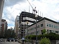
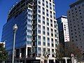
The building is sited immediately north of the two Waterplace Towers, at the intersection of American Express Plaza and Exchange Street. At a height of 237 ft (72 m), it is currently the seventh-tallest building in the city and state.

Waterplace Towers

Waterplace Towers is the name of a high-rise residential condominium project in Providence, Rhode Island. The project completed construction in mid-2008, and was developed by Intercontinental Real Estate Corporation.

Purpose

The public health insurer announced April 19, 2007, its intention to consolidate its operations comprising 1100 employees, which had been scattered throughout the city, into one 325,000 sq ft (30,200 m2) 12-story building. [2] [3] The $114 million tower will be built on top of a parking garage currently under construction for Intercontinental's neighboring Waterplace condominiums, and is estimated to be finished by early 2010. The economic feasibility of this move is made possible through $25 million worth of tax breaks negotiated with Intercontinental.

Opinion

Mayor David Cicilline was optimistic at the prospect of retaining the 1100 employees in the city adding to the "economy and add to the life and vitality of our city", while the state's governor, Donald Carcieri, worried about the impact a move to occupy such expensive real estate would have on the premiums for the insurer's customers, since the first priority of the Blue Cross & Blue Shield should be the affordable coverage of citizens.

David Cicilline American politician

David Nicola Cicilline is an American politician who has been the U.S. Representative for Rhode Island's 1st congressional district since 2011. He is a member of the Democratic Party. He previously served as Mayor of Providence, Rhode Island, from 2003 to 2011, and was the first openly gay mayor of a U.S. state capital.

Donald Carcieri American politician

Donald Louis Carcieri is an American politician and corporate executive who served as the 73rd Governor of Rhode Island from January 2003 to January 2011. Carcieri has worked as a manufacturing company executive, aid relief worker, bank executive, and teacher.

Related Research Articles

Union Station (Providence) former railway stations in Providence, Rhode Island, United States

Union Station describes two distinct defunct train stations in Providence, Rhode Island.

Industrial National Bank Building building in the city of Providence, Rhode Island, United States

Industrial National Bank Building, located at 111 Westminster Street is the tallest building in the city of Providence, Rhode Island, the tallest in the state of Rhode Island, and the 28th tallest in New England. Standing at 428 feet (130 m) with 26 floors, the building occupies a footprint on the eastern periphery of Kennedy Plaza. The building, an iconic local landmark, has been vacant since April 2013.

Davisville, Rhode Island human settlement in Rhode Island, United States of America

Davisville, Rhode Island is a village in the town of North Kingstown in the U.S. state of Rhode Island that was formerly the home of the Davisville Naval Construction Battalion Center, which housed the United States Navy's SeaBees.

Textron Tower skyscraper in Providence, Rhode Island (US)

The Textron Tower, formerly the Old Stone Tower, is an International-style skyscraper in downtown Providence, Rhode Island. It is the world headquarters of Textron.

Construction projects in Providence

As a consequence of the city of Providence, Rhode Island's so-called "Renaissance" that started in the 1970s, free land and economic conditions became favorable to large projects in the late 1990s. Most of the new projects consist of hotel and condominium development in new and existing buildings, but two new office towers are underway as well. As a result, within 3 years Providence would have a new corporate headquarters, and four new buildings over 60 m (200 ft) in height.

History of Providence, Rhode Island

The Rhode Island city of Providence has a nearly 400-year history integral to that of the United States, including significance in the Transatlantic Slave Trade and the American Revolutionary War by providing leadership and fighting strength, quartering troops, and supplying goods to residents by circumventing the blockade of Newport. The city is also noted for the first bloodshed of the American Revolution in the Gaspée Affair. Additionally, Providence is notable for economic shifts, moving from trading to manufacturing; the decline of manufacturing devastated the city during the Great Depression, but the city eventually attained economic recovery through investment of public funds.

Omni Providence Hotel

The Omni Providence Hotel is a Neo-Traditionalist skyscraper in downtown Providence, Rhode Island. At 100 m (328 ft), it became the fourth-tallest building in the city and the state on 15 February 2007, when the nearby slightly taller The Residences at the Westin topped out. Brick facades and a pitched roof adorn the building.

Cathedral of Saints Peter and Paul (Providence, Rhode Island) Church in Rhode Island, United States

The Cathedral of Saints Peter and Paul is a Roman Catholic cathedral in the Cathedral Square neighborhood of Providence, Rhode Island, United States. It is the mother church of the Diocese of Providence. The Romanesque church was designed in 1873 by Patrick Keely and added to the National Register of Historic Places in 1975.

Burnside Park, Providence, Rhode Island small park in downtown Providence, Rhode Island

Burnside Park is a small park situated in downtown Providence, Rhode Island, adjacent to Kennedy Plaza. Named for Ambrose Burnside, a general in the American Civil War from Rhode Island, an equestrian statue was erected in his honor in the late 19th century, and sits in the center of the park. Burnside Park was the location of the camp of the Occupy Providence Movement during the Fall of 2011.

Downtown, Providence, Rhode Island central economic, political, and cultural district of the city of Providence, Rhode Island, USA

Downtown, also known as Downcity, is the central economic, political, and cultural district of the city of Providence, Rhode Island. It is bounded on the east by Canal Street and the Providence River, to the north by Smith Street, to the west by Interstate 95, and to the south by Henderson Street. I-95 serves as a physical barrier between the city's commercial core and neighborhoods of Federal Hill, West End, and Upper South Providence. Most of the downtown is listed on the National Register of Historic Places as the Downtown Providence Historic District.

The Sister Dominica Manor

The Sister Dominica Manor, also known as Federal Hill Manor and originally called Bradford House, is a high-rise building located in the Federal Hill district of Providence, Rhode Island. Standing at 175 feet, it is currently the 15th-tallest building in the city. The Sister Domininca Manor has 16 floors, and was completed in 1966.

Jewelry District (Providence) human settlement in Rhode Island, United States of America

The Jewelry District is a neighborhood of Providence, Rhode Island located just south of Downtown between Interstate 195 and Henderson Street. Interstate 95 lies at the western edge of the neighborhood, which includes Davol Square and the waterfront along the west bank of the Providence River. The neighborhood was home to a large number of jewelry manufacturing companies beginning in the 19th century. The area was detached from the rest of downtown with the construction of Interstate 195 in the 1960s. However, a major construction project, known as the "Iway" is currently under way to relocate Interstate 195 further south, thereby reconnecting the district with Downtown.

Pawtucket/Central Falls station

Pawtucket/Central Falls station is a disused railroad station located in the Rhode Island cities of Pawtucket and Central Falls. It opened in 1916 to replace separate stations in the two cities and was closed in 1981. The state of Rhode Island intends to open a replacement station slightly to the south around 2022.

Rhode Island Convention Center

The Rhode Island Convention Center is an exposition center in downtown Providence, RI. Opened in 1993, it is the largest convention center in Rhode Island, with about 130,000 square feet (12,000 m2) of exhibition space, including a 100,000-square-foot (9,300 m2) exhibit hall. It is connected by skybridges to the Dunkin' Donuts Center, and the adjacent Omni Hotels Omni Providence Hotel. The ground level features a main exhibition hall with 100,000 square feet, and the upper level has a ballroom and meeting halls. The building has a five-story glass front with a large space outside the meeting rooms and exhibit halls where visitors can gather and mingle.

Belton Court historic estate in Barrington, Rhode Island

Belton Court is a historic estate on Middle Highway in Barrington, Rhode Island.

Brown and Sharpe Manufacturing Company Complex

The Brown & Sharpe Manufacturing Company Complex is a historic factory complex in Providence, Rhode Island along the Woonasquatucket River. The 25-acre (10 ha) complex occupies most of a large city block bounded on the south by Promenade Street, the west by Bath and Calverly Streets, the north by West Park Street, and the east by Interstate 95. The complex was the longtime home of Brown & Sharpe Manufacturing Company, a manufacturer of precision equipment founded in 1833. The company was originally located in downtown Providence, but moved to this site in 1872, where it remained until 1964, when it moved to North Kingstown. Fourteen of the company's buildings survive.

Cranston Street Armory

The Cranston Street Armory is an historic building in the Broadway–Armory Historic District of Providence, Rhode Island. It was built in 1907 at a cost of $650,000.00. The building was occupied by the Rhode Island National Guard from its opening until 1996. Since then, parts of the building have been used as film studios, and some of its offices occupied by the Rhode Island State Fire Marshal. The National Trust for Historic Preservation listed the Armory as one of "America's 11 Most Endangered Historic Places" in its annual list for 1997. Its distinctive yellow bricks, crenellated turrets, and decorative stonework mark it as a historically significant building and neighborhood icon.

References

Coordinates: 41°49′42″N71°24′48″W / 41.828258°N 71.413242°W / 41.828258; -71.413242

Geographic coordinate system Coordinate system

A geographic coordinate system is a coordinate system that enables every location on Earth to be specified by a set of numbers, letters or symbols. The coordinates are often chosen such that one of the numbers represents a vertical position and two or three of the numbers represent a horizontal position; alternatively, a geographic position may be expressed in a combined three-dimensional Cartesian vector. A common choice of coordinates is latitude, longitude and elevation. To specify a location on a plane requires a map projection.