Bridge River, British Columbia

Last updated

Bridge River was used to describe three separate towns or localities in the Lillooet Country of the Interior of British Columbia connected with the river and valley of the same name.

The Lillooet Country, also referred to as the Lillooet District, is a region spanning from the central Fraser Canyon town of Lillooet west to the valley of the Lillooet River, and including the valleys in between, in the Southern Interior of British Columbia. Like other historical BC regions, it is sometimes referred to simply as The Lillooet or even Lillooet,.

The British Columbia Interior, BC Interior or Interior of British Columbia, usually referred to only as the Interior, is one of the three main regions of the Canadian province of British Columbia, the other two being the Lower Mainland, which comprises the overlapping areas of Greater Vancouver and the Fraser Valley, and the Coast, which includes Vancouver Island and also including the Lower Mainland.

Contents

History

1858-60

The boomtown of Bridge River was one of a half-dozen gold rush-era settlements which sprang up in the vicinity of today's Lillooet, the others being Cayoosh Flat (Lillooet itself), Parsonsville, Marysville, the Upper Fountain (Fountain), and Pavilion. Located at the confluence of the Bridge River with the Fraser, the location of the Bridge River Fishing Grounds (aka Six Mile or Setl) the town sprang up around a toll bridge spanning the rapids, aka the Lower Fountain, as the location of this townsite was also called. The bridge was built by an entrepreneur who tore down a First Nations-built pole bridge which had spanned the river at the same spot. The resulting town included hotels, a bank, a barber and various "restaurants" and a blacksmith's, but it vanished very quickly as the river crossing at this point did not turn out to be popular, as ferry crossings farther downstream were closer to Cayoosh Flat and Parsonsville, which were across the river from each other, and charged fares competitive with the bridge tolls. No mention is made of when the bridge was torn down, or when the last surviving remnant of the town's buildings and businesses finally closed. Nothing survives of the townsite today. On the triangle of bench above the confluence of the rivers there are a couple of old log-cabin ruins, but they are remnants of a rancherie of the Xwisten First Nation, the Bridge River Indian Band, who now mostly live farther up the Bridge River a few miles.

Boomtown community that experiences sudden and rapid population and economic growth

A boomtown is a community that undergoes sudden and rapid population and economic growth, or that is started from scratch. The growth is normally attributed to the nearby discovery of a precious resource such as gold, silver, or oil, although the term can also be applied to communities growing very rapidly for different reasons, such as a proximity to a major metropolitan area, huge construction project, or attractive climate.

A Rancherie is a First Nations residential area of an Indian Reserve in colloquial English throughout the Canadian province of British Columbia. Originating in an adaptation of ranchería, a Californian term for the residential area of a rancho, where most hands were aboriginal, the term became in British Columbia prior to the Fraser Canyon Gold Rush of 1858, but from then on and in the series of gold rushes and settlement colonization that followed, the term came into wide use throughout the colony.

The Bridge River Indian Band also known as the Nxwísten First Nation, the Xwisten First Nation, and the Bridge River Band, is a First Nations government located in the Central Interior-Fraser Canyon region of the Canadian province of British Columbia. It is a member of the Lillooet Tribal Council, which is the largest grouping of band governments of the St'at'imc people.

1880s-1910s

The scattered population of the upper Bridge River in the days of its early exploration commonly referred to themselves as the residents of Bridge River, meaning the district and basin, although no town in the vicinity ever wore the name itself. Generally, especially in later years, residents of the upper Bridge River basin or the goldfield towns which eventually sprang up around it used the phrase "the Bridge River" to refer to the collection of communities, although as these became more well-established the specific usage to mean the upper goldfields area shifted to mean the entirety of the Bridge River Country, which includes the adjacent basin of Anderson and Seton Lakes. The residents of the lower Bridge River - below its Big Canyon - sometimes refer to themselves as living in "Bridge River" but normally will refer to the specific locality where they live - Moha, Applespring, Antoine Creek.

Anderson Lake (British Columbia) lake in Canada

Anderson Lake is located about 25 miles North of the town of Pemberton, British Columbia and is about 28.5 km² in area and around 21 km (13 mi) in length. Its maximum depth is 215 meters. It is drained by the Seton River, which feeds Seton Lake and so the Fraser River. It is fed by the Gates River, which drains from the Pemberton Pass divide with the Birkenhead River valley towards Pemberton-Mount Currie.

Seton Lake lake in Canada

Seton Lake is a freshwater fjord draining east via the Seton River into the Fraser River at the town of Lillooet, British Columbia, about 22 km long and 243 m in elevation and 26.2 square kilometres in area. Its depth is 1500 feet.

1920s-1960s

The name Bridge River also become the local convention for the hydroelectric townsite of the Bridge River Power Project at South Shalalth on Seton Lake following its establishment in the 1920s. This usage fell out of use after completion of the hydroelectric project, when most residents moved away and the economic and social character of the Lillooet Country changed as a result. The townsite was a model development by the 1920s power company which launched and then abandoned the project, and included well-built beam-frame houses, a fine hotel geared at mine-bound investors, community hall, skating rink-tennis court, and landscaped gardens. Virtually empty during the 1930s the townsite became one of the five relocation centres for Japanese-Canadian internees in the Lillooet area and thereby became the temporary home of Dr. Masajiro Miyazaki, who was appointed coroner in Lillooet during the war despite his internment and became one of Lillooet's two Order of Canada inductees.

Bridge River Power Project

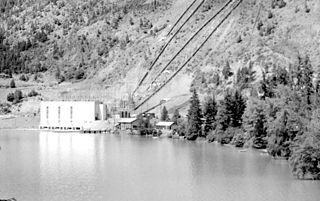
The Bridge River Power Project is a hydroelectric power development in the Canadian province of British Columbia, located in the Lillooet Country between Whistler and Lillooet. It harnesses the power of the Bridge River, a tributary of the Fraser, by diverting it through a mountainside to the separate drainage basin of Seton Lake, utilizing a system of three dams, four powerhouses and a canal.

Japanese Canadian internment Period of internment of Japanese people in Canada

In 1942, Japanese Canadian Internment occurred when over 22,000 Japanese Canadians from British Columbia were evacuated and interned in the name of "national security". This decision followed the events of the Japanese invasions of British Hong Kong and Malaya, the attack on Pearl Harbor in Hawaii, and the subsequent Canadian declaration of war on Japan during World War II. This forced relocation subjected many Japanese Canadians to government-enforced curfews and interrogations, job and property losses, and forced repatriation to Japan.

Masajiro Miyazaki, CM was a Japanese-Canadian osteopathic physician who practised in Vancouver prior to World War II. During World War II, he was appointed as a coroner by the British Columbia Provincial Police in the town of Lillooet, British Columbia. In addition to coroner's duties he also served as effective general practitioner in the Lillooet area, including for the area's four wartime "self-supporting centres". Miyazaki's practice also included the Japanese Canadian internment camp at Taylor Lake. Towards the end of his life, Miyazaki was recognized for his services to the community, which included founding the local ambulance service and instigating a proper hospital for Lillooet, by being enrolled in the Order of Canada.

After World War II, the townsite was expanded as the power project was revived and went into full swing. In addition to new housing built on the ridgetop above the village, and extensive trailer camps and other housing at nearby Seton Portage and in Shalalth proper, and facilities in the original townsite were expanded to include large modern bunkhouses and a movie theatre, although the hotel had burned down in the early 1950s.

Seton Portage human settlement in Canada

Seton Portage is an historic rural community in British Columbia, Canada, that is about 25 km (16 mi) west of Lillooet, located between Seton Lake and Anderson Lake. "The Portage" was formed about 10,000 years ago when the flank of the Cayoosh Range, which is the south flank of the valley, let go and slid into the middle of what had been a single lake. The result is a location similar to Interlaken, Switzerland, with two fjord-style lakes flanking a narrow and very short strip of land between them.

Related Research Articles

Statimc ethnic group

The St'at'imc, also known as the Lillooet, St̓át̓imc, Stl'atl'imx, etc., are an Interior Salish people located in the southern Coast Mountains and Fraser Canyon region of the Interior of the Canadian province of British Columbia.

Shalalth Place in British Columbia, Canada

Shalalth, pop. c. 400, is one of the main communities of the Seton Lake Band of the St'at'imc (Lillooet) Nation and location of the two main powerhouses of the Bridge River Power Project.

The Cayoosh Gold Rush was one of several in the history of the region surrounding Lillooet, British Columbia, Canada. If estimates of its yield are true, it would be one of the richest single finds in the gold mining history of that province.

N'Quatqua, variously spelled Nequatque, N'quat'qua, is the proper historic name in the St'at'imcets language for the First Nations village of the Stl'atl'imx people of the community of D'Arcy, which is at the upper end of Anderson Lake about 35 miles southeast of Lillooet and about the same distance from Pemberton. The usage is synonymous with Nequatque Indian Reserve No. 1, which is 177 ha. in size and located adjacent to the mouth of the Gates River.

Seton Portage Historic Provincial Park

Seton Portage Historic Provincial Park is a provincial park in British Columbia, Canada.

Seton Lake First Nation

The Seton Lake First Nation, a.k.a. the Seton Lake Indian Band, is a First Nations government located in the Central Interior-Fraser Canyon region of the Canadian province of British Columbia. It is a member of the Lillooet Tribal Council, which is the largest grouping of band governments of the St'at'imc people. Other St'at'imc governments include the smaller In-SHUCK-ch Nation on the lower Lillooet River to the southwest, and the independent N'quatqua First Nation at the farther end of Anderson Lake from Seton Portage, which is the location of three of the band's reserve communities.

The Bridge River Country is a historic geographic region and mining district in the Interior of British Columbia, Canada, lying between the Fraser Canyon and the valley of the Lillooet River, south of the Chilcotin Plateau and north of the Lillooet Ranges. "The Bridge River" can mean the Bridge River Country as opposed to the Bridge River itself, and is considered to be part of the Lillooet Country, but has a distinct history and identity within the larger region. As Lillooet is sometimes considered to be the southwest limit of the Cariboo, some efforts were made to refer to the Bridge River as the "West Cariboo" but this never caught on.

Vessels of the Lakes Route

The Lakes Route is an alternate name for the Douglas Road, which was the first formally designated "road" into the Interior of British Columbia, Canada from its Lower Mainland area flanking the Lower Fraser River. Also known as the Douglas-Lillooet Trail or the Lillooet Trail, the route consisted of a series of wagon roads connected via lake travel in between. A variety of craft were used on the lakes, from steamboats to sail-driven rafts to, through the early 20th Century, diesel and other engines. Lake travel continued for commerce, passenger travel and heavy freight until after World War II.

Bralorne

Bralorne is an historic Canadian gold mining community in the Bridge River District, some eighty dirt road miles west of the town of Lillooet.

The Seton Canal is a diversion of the flow of the Seton River from Seton Dam, just below the flow of Seton Lake, to the Seton Powerhouse on the Fraser River at the town of Lillooet, British Columbia, Canada. The canal bridges Cayoosh Creek 300m below its commencement and is about 3.5 km in length, ending just below a bridge used by the Texas Creek Road, where the canal's waterflow is fed into tunnels which feed the Seton Powerhouse on the farther side of a small rocky hill. Most of the water carried by the canal is the volume of the diverted Bridge River, which is fed into Seton Lake via the Bridge River generating stations at Shalalth, 16 km to the west, which are supplied by diversion tunnels through Mission Ridge from Carpenter Lake, the reservoir created by Terzaghi Dam.

Cayoosh Creek river in Canada

Cayoosh Creek is a northeast-flowing tributary of the Seton River in the Canadian province of British Columbia. The name Cayoosh Creek remains on the bridge-sign crossing the stream on BC Highway 99 and continues in use locally to refer to the final reaches of the Seton River, formerly Seton Creek, which prior to the renaming ending at the confluence with Cayoosh Creek. The creek is the namesake of Cayoosh Creek Indian Reserve No. 1, one of the main Indian reserves of the Cayoose Creek Indian Band, which lies adjacent to what was renamed the Seton River without local consultation.

Mission Ridge, also known as Mission Mountain, is a ridge in the Bridge River-Lillooet Country of the South-Central Interior of British Columbia, Canada, extending westward from the town of Lillooet along the north side of Seton Lake to Mission Pass, which is immediately above and to the north of the lakeside community of Shalalth. The road over the pass is also known as Mission Mountain, which is short for "Mission Mountain Road". Mission Creek lies on the north side of the pass, and is a tributary of the Bridge River, the lower reaches of which lie on the north side of the ridge, and which was the only road access into the upper Bridge River Country before the construction of a road through the Bridge River Canyon in the mid-1950s opened that region up to road access from the lower Bridge River valley and the town of Lillooet via the community or Moha. Most, or virtually all, of the ridge, is Indian Reserves, notably Slosh 1, under the administration of the Seton Lake Indian Band, and Bridge River 1, which is under the administration of the Bridge River Indian Band. Parts of the ridge's eastern end are in reserves controlled by the Lillooet Indian Band, including its final spires above Lillooet, which were dubbed St. Mary's Mount by the Reverend Lundin Brown in the 1860s, though that name never stuck and is ungazetted.

The Bridge River Rapids, also known as the Six Mile Rapids, the Lower Fountain, the Bridge River Fishing Grounds, and in the St'at'imcets language as Sat' or Setl, is a set of rapids on the Fraser River, located in the central Fraser Canyon at the mouth of the Bridge River six miles north of the confluence of Cayoosh Creek with the Fraser and on the northern outskirts of the District of Lillooet, British Columbia, Canada.

References

International Standard Book Number Unique numeric book identifier

The International Standard Book Number (ISBN) is a numeric commercial book identifier which is intended to be unique. Publishers purchase ISBNs from an affiliate of the International ISBN Agency.

See also

Coordinates: 50°44′N122°14′W / 50.733°N 122.233°W / 50.733; -122.233