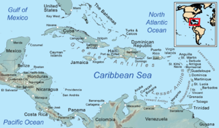
Antigua and Barbuda is a country in the West Indies in the Americas, lying between the Caribbean Sea and the Atlantic Ocean. It consists of two major islands, Antigua and Barbuda, and a number of smaller islands. The permanent population numbers about 81,800 and the capital and largest port and city is St. John's on Antigua. Lying near each other, Antigua and Barbuda are in the middle of the Leeward Islands, part of the Lesser Antilles, roughly at 17°N of the equator.

The geography of France consists of a terrain that is mostly flat plains or gently rolling hills in the north and west and mountainous in the south and the east.

The Gulf of Saint Lawrence is the outlet of the North American Great Lakes via the Saint Lawrence River into the Atlantic Ocean. The gulf is a semienclosed sea, covering an area of about 226,000 square kilometres (87,000 sq mi) and containing about 34,500 cubic kilometres (8,300 cu mi) of water, which results in an average depth of 152 metres (499 ft).

This is a list of the extreme points of North America: the points that are highest and lowest, and farther north, south, east or west than any other location on the continent. Some of these points are debatable, given the varying definitions of North America.
Area code 767 is the local telephone area code of the Commonwealth of Dominica, within the North American Numbering Plan. Area 767 was created with the start of permissive dialing on 1 October 1997, ending 30 September 1998, as a split from area 809, which formerly covered 19 Caribbean territories. The number 767 corresponds to the letters ROS and may be mnemonic for Roseau, Dominica's capital city.

Charlotte is the largest parish of Saint Vincent and the Grenadines, situated on the eastern coast of the island of Saint Vincent. With an area of 149 km², its size is comparable to that of the British Virgin Islands.) The parish has the longest coastline of all the parishes and is also larger than the three smallest parishes combined. The parish possesses a very rough and rugged topography with very little flat land occurring towards the coast. as a result of these features, parts of the north of the parish cannot be accessed by a main road. Up until the building of a bridge over the Rabacca Dry River access to the north side of the river was not possible when rain caused the river to swell and make the path impassable.

Saint Patrick is an administrative parish of Saint Vincent and the Grenadines, on the island of Saint Vincent. The parish consists of the middle portion of the leeward side of the main island. Its capital is Barrouallie.

Grenadines is an administrative parish of Saint Vincent and the Grenadines. Its capital is Port Elizabeth.

Saint Andrew is an administrative parish of Saint Vincent and the Grenadines, on the island of Saint Vincent. Its capital is Layou.

The Cul De Sac River is a river in Saint Lucia. It flows north and then west from the central highlands in the south of the island, reaching the Caribbean Sea to the south of the capital, Castries. It is one of the longest rivers in Saint Lucia.
The Roseau River is a river in Saint Lucia. It flows north and then west from the central highlands in the south of the island, reaching the Caribbean Sea to the north of the town of Anse la Raye. The Roseau river is also the longest in the country and is dammed by the John Compton Dam near Millet.

The Wallilabou River is a river in the northwest of Saint Vincent. It rises in the Grand Bonhomme Mountains in the centre of the island and flows Northwest to reach the Caribbean Sea North of Barroulie.The Wallilabou Falls-a tourist attraction-is located on this river, a short walk Northeast along the Leeward Highway. Several of the scenes from the film Pirates of the Caribbean: The Curse of the Black Pearl were filmed close to the mouth of the river.
The Maguse River is located in the Kivalliq Region of northern Canada's territory of Nunavut. It originates at Maguse Lake and flows 56 km (35 mi) eastward to northwestern Hudson Bay. At one time, there was a trading post at the mouth of the river.
The River Canari is a river on the Caribbean island of Dominica. The adjacent rock formation, which is a persistent 80 degrees Celsius much of the year, has been discussed as a potential site for an enhanced geothermal system for electricity generation.
Clarke's River is a river on the Caribbean island of Dominica.
The Maréchal River is a river on the Caribbean island of Dominica.
The Rabacca Dry River is a river of Saint Vincent and the Grenadines. It is a seasonal river and will only flow like a normal when there is heavy rainfall. It is located on the outskirts of Georgetown. It was formed as a result of the eruption of the La Soufriere volcano, there is its source.
The Antoine River is a river of Grenada which is located in the Caribbean Sea .


