Bush River (South Carolina)

Last updated

The Bush River is a tributary of the Saluda River, 30 mi (48 km) long, in the Piedmont region of western South Carolina in the United States. Via the Saluda and Congaree Rivers, it is part of the watershed of the Santee River, which flows to the Atlantic Ocean.

Tributary stream or river that flows into a main stem river or lake

A tributary or affluent is a stream or river that flows into a larger stream or main stem river or a lake. A tributary does not flow directly into a sea or ocean. Tributaries and the main stem river drain the surrounding drainage basin of its surface water and groundwater, leading the water out into an ocean.

Saluda River river in the United States of America

The Saluda River is a principal tributary of the Congaree River, about 200 mi (320 km) long, in northern and western South Carolina in the United States. Via the Congaree River, it is part of the watershed of the Santee River, which flows to the Atlantic Ocean.

Piedmont (United States) plateau region located in the eastern United States

The Piedmont is a plateau region located in the Eastern United States. It sits between the Atlantic coastal plain and the main Appalachian Mountains, stretching from New Jersey in the north to central Alabama in the south. The Piedmont Province is a physiographic province of the larger Appalachian division which consists of the Gettysburg-Newark Lowlands, the Piedmont Upland and the Piedmont Lowlands sections.

Contents

According to the Geographic Names Information System, it has also been known as "Bush Creek." The United States Board on Geographic Names settled on "Bush River" as the stream's name in 1973.

Geographic Names Information System geographical database

The Geographic Names Information System (GNIS) is a database that contains name and locative information about more than two million physical and cultural features located throughout the United States of America and its territories. It is a type of gazetteer. GNIS was developed by the United States Geological Survey in cooperation with the United States Board on Geographic Names (BGN) to promote the standardization of feature names.

United States Board on Geographic Names US geographic naming government agency

The United States Board on Geographic Names (BGN) is a federal body operating under the United States Secretary of the Interior. The purpose of the board is to establish and maintain uniform usage of geographic names throughout the federal government of the United States.

Course

The Bush River rises in Laurens County, just south of the town of Clinton, and flows generally southeastwardly into Newberry County, past Joanna. It joins into the Saluda River about 11 mi (17 km) south of Newberry as part of Lake Murray, which is formed on the Saluda by Saluda Dam.

Laurens County, South Carolina County in the United States

Laurens County is a county located in the U.S. state of South Carolina. As of the 2010 census, its population was 66,537. Its county seat is Laurens.

Clinton, South Carolina City in South Carolina, United States

Clinton is a city in Laurens County, South Carolina, United States. The population was 8,490 as of the 2010 census. It is part of the Greenville–Mauldin–Easley Metropolitan Statistical Area. Clinton is the home of Presbyterian College.

Newberry County, South Carolina County in the United States

Newberry County is a county located in the U.S. state of South Carolina. As of the 2010 census, its population was 37,508. Its county seat is Newberry. The name is of unknown origin.

See also

Sources

DeLorme company

DeLorme is a producer of personal satellite tracking, messaging, and navigation technology. The company’s main product, inReach, integrates GPS and satellite technologies. inReach provides the ability to send and receive text messages anywhere in the world by using the Iridium satellite constellation. By pairing with a smart phone, navigation is possible with access to free downloadable topographic maps and NOAA charts. On February 11, 2016, the company announced that it had been purchased by Garmin, a multinational producer of GPS products and services.

International Standard Book Number Unique numeric book identifier

The International Standard Book Number (ISBN) is a numeric commercial book identifier which is intended to be unique. Publishers purchase ISBNs from an affiliate of the International ISBN Agency.

Coordinates: 34°07′09″N81°35′54″W / 34.119182°N 81.598306°W / 34.119182; -81.598306

Geographic coordinate system Coordinate system

A geographic coordinate system is a coordinate system that enables every location on Earth to be specified by a set of numbers, letters or symbols. The coordinates are often chosen such that one of the numbers represents a vertical position and two or three of the numbers represent a horizontal position; alternatively, a geographic position may be expressed in a combined three-dimensional Cartesian vector. A common choice of coordinates is latitude, longitude and elevation. To specify a location on a plane requires a map projection.


Related Research Articles

Saluda County, South Carolina County in the United States

Saluda County is a county in the U.S. state of South Carolina. As of the 2010 census, the population was 19,875. Its county seat is Saluda. The county was formed from northern and eastern portions of Edgefield County.

Little Kanawha River river in the United States of America

The Little Kanawha River is a tributary of the Ohio River, 169 mi (269 km) long, in western West Virginia in the United States. Via the Ohio, it is part of the watershed of the Mississippi River, draining an area of 2,320 mi² (6,009 km²) on the unglaciated portion of the Allegheny Plateau. It served as an important commercial water route in the early history of West Virginia, particularly in the logging and petroleum industries.

Lake Murray Country is a large area of South Carolina, United States; the region includes the counties of Newberry, Saluda, Lexington, and Richland.

Broad River (Carolinas) river in North and South Carolina, United States

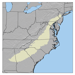
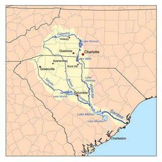
The Broad River is a principal tributary of the Congaree River, about 150 miles (240 km) long, in western North Carolina and northern South Carolina in the United States. Via the Congaree, it is part of the watershed of the Santee River, which flows to the Atlantic Ocean.

Whetstone River river in the United States of America

The Whetstone River is a 12.7-mile-long (20.4 km) tributary of the Minnesota River in northeastern South Dakota and a very small portion of western Minnesota in the United States. Via the Minnesota River, it is part of the watershed of the Mississippi River.

Reedy River river in the United States of America

The Reedy River is a tributary of the Saluda River, about 65 miles (105 km) long, in northwestern South Carolina in the United States. Via the Saluda and Congaree Rivers, it is part of the watershed of the Santee River, which flows to the Atlantic Ocean.

Uwharrie River river in the United States of America

The Uwharrie River is a river, about 60 mi (100 km) long, in the Piedmont region of central North Carolina in the United States. It is a tributary of the Pee Dee River, which flows to the Atlantic Ocean.

Canoochee River river in the United States of America

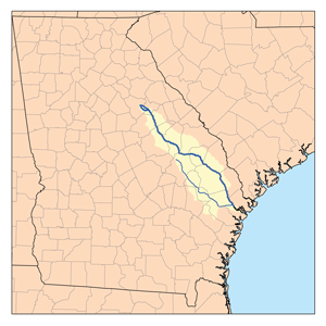
The Canoochee River is a 108-mile-long (174 km) river in southeastern Georgia in the United States. It is a tributary of the Ogeechee River, which flows to the Atlantic Ocean. In 1738 the Trustees of the colony mentioned the proposed house and ferry boat over the 'Cooanoochi River'.

Wateree River river in the United States of America

The Wateree River, about 75 mi (120 km) long, is a tributary of the Santee River in central South Carolina in the United States, which flows to the Atlantic Ocean. Its name recalls the now-extinct Wateree Native Americans, who lived in the area until displaced by European settlers.

The Banister River is a tributary of the Dan River, about 65 mi (105 km) long, in southern Virginia in the United States. Via the Dan, it is part of the watershed of the Roanoke River, which flows to the Atlantic Ocean. It rises on Brier Mountain in western Pittsylvania County and flows generally eastwardly into Halifax County, past the town of Halifax. It joins the Dan River 6 mi (9.7 km) east of the town of South Boston.

The First Broad River is a tributary of the Broad River, about 60 mi (95 km) long in western North Carolina in the United States. Via the Broad and Congaree Rivers, it is part of the watershed of the Santee River, which flows to the Atlantic Ocean.

The Pacolet River is a tributary of the Broad River, about 50 miles (80 km) long, in northwestern South Carolina in the United States. One of its principal headwaters tributaries also drains a small portion of western North Carolina. Via the Broad and Congaree Rivers, it is part of the watershed of the Santee River, which flows to the Atlantic Ocean. The stream's name has also been spelled historically as "Pacolate River". There is a Pacolet River in Polk County in Florida.

The Second Broad River is a tributary of the Broad River in western North Carolina in the United States. Via the Broad and Congaree rivers, it is part of the watershed of the Santee River, which flows to the Atlantic Ocean.

The Enoree River is a tributary of the Broad River, 85 mi (137 km) long, in northwestern South Carolina in the United States. Via the Broad and Congaree Rivers, it is part of the watershed of the Santee River, which flows to the Atlantic Ocean.

The Sandy River and its tributary the Little Sandy River are short rivers in north-central South Carolina in the United States. The Sandy is a tributary of the Broad River; via the Broad and Congaree Rivers, it is part of the watershed of the Santee River, which flows to the Atlantic Ocean.

Killbuck Creek river in the United States of America

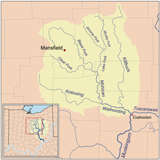
Killbuck Creek is a tributary of the Walhonding River, 81.7 mi long, in north-central Ohio in the United States. Via the Walhonding, Muskingum and Ohio Rivers, it is part of the watershed of the Mississippi River. It drains an area of 613 mi².

The Mitchell River is a tributary of the Yadkin River in northwestern North Carolina in the United States. Via the Yadkin it is part of the watershed of the Pee Dee River, which flows to the Atlantic Ocean. According to the Geographic Names Information System, it has also been known historically as "Mitchells River," "Mitchels River," and "Mountain Creek."

The Roaring River is a tributary of the Yadkin River in northwestern North Carolina in the United States. Via the Yadkin it is part of the watershed of the Pee Dee River, which flows to the Atlantic Ocean. According to the Geographic Names Information System, it has also been known historically as "Roaring Creek." The river's name comes from its headwaters in the Blue Ridge Mountains, where it flows through a series of small waterfalls.

The Ararat River is a tributary of the Yadkin River in southwestern Virginia and northwestern North Carolina in the United States. Via the Yadkin it is part of the watershed of the Pee Dee River, which flows to the Atlantic Ocean.