
The Santa Clarita Valley is part of the upper watershed of the Santa Clara River in Southern California. The valley was part of the 48,612-acre (19,673 ha) Rancho San Francisco Mexican land grant. Located in Los Angeles County, its main population center is the city of Santa Clarita which includes the communities of Canyon Country, Newhall, Saugus, and Valencia. Adjacent unincorporated communities include Castaic, Stevenson Ranch, Val Verde, and the new master planned community of Newhall Ranch.

The Tehachapi Mountains are a mountain range in the Transverse Ranges system of California in the Western United States. The range extends for approximately 40 miles (64 km) in southern Kern County and northwestern Los Angeles County.

The Tejon Pass, previously known as Portezuelo de Cortes, Portezuela de Castac, and Fort Tejon Pass, is a mountain pass between the southwest end of the Tehachapi Mountains and northeastern San Emigdio Mountains, linking Southern California north to the Central Valley. It has been traversed by major roads such as the El Camino Viejo, the Stockton – Los Angeles Road, the Ridge Route, U.S. Route 99, and now Interstate 5.
Pyramid Dam is a dam on Piru Creek located in northern Los Angeles County, north of Castaic and south of Gorman. Its reservoir, Pyramid Lake, stores water from the West Branch California Aqueduct for Ventura County and Los Angeles County. They are smaller than Castaic Dam and Lake, the other artificial water storage facility in the area, 7 miles (11 km) to the south.

Pyramid Lake is a reservoir formed by Pyramid Dam on Piru Creek in the eastern San Emigdio Mountains, near Castaic, Southern California. It is a part of the West Branch California Aqueduct, which is a part of the California State Water Project. Its water is fed by the system after being pumped up from the San Joaquin Valley and through the Tehachapi Mountains.

Tejon Ranch Company, based in Lebec, California is one of the largest private landowners in California. The company was incorporated in 1936 to organize the ownership of a large tract of land that was consolidated from four Mexican land grants acquired in the 1850s and 60s by ranch founder General Edward Fitzgerald Beale. The company now owns over 270,000 acres (1,093 km2) in the southern San Joaquin Valley, Tehachapi Mountains, and Antelope Valley. It is the largest contiguous piece of private property in the state. Tejon Ranch’s agricultural operation primarily grows almonds, pistachios, and wine grapes, along with some alfalfa and the occasional row crop. Cattle leases cover about 250,000 acres (1,012 km2), and depending on the season, up to 12,000 head of cattle can be found grazing on the ranch.

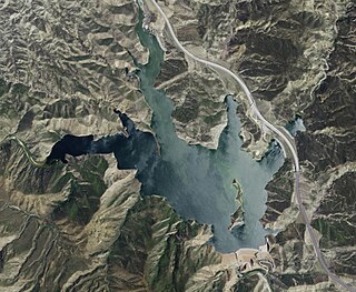
Castaic Dam is an embankment dam in northern Los Angeles County, California, near the unincorporated area of Castaic. Although located on Castaic Creek, a major tributary of the Santa Clara River, Castaic Creek provides little of its water. The lake is the terminus of the West Branch of the California Aqueduct, part of the State Water Project. The dam was built by the California Department of Water Resources and construction was completed in 1973. The lake has a capacity of 325,000 acre feet (401,000,000 m3) and stores drinking water for the western portion of the Greater Los Angeles Area.

Castaic Creek is a 25.0-mile-long (40.2 km) stream in the Sierra Pelona Mountains, in northeastern Los Angeles County, California. It is a tributary of the Santa Clara River.
Rancho La Liebre was a 48,800-acre (197 km2) Mexican land grant in present-day Kern County, California and Los Angeles County, given in 1846 by Governor Pío Pico to José María Flores. Liebre means "Hare" in Spanish and the rancho was named as such because of the abundance of jack rabbits in the area.
Rancho Los Alamos y Agua Caliente was a 26,626-acre (107.75 km2) Mexican land grant in present day Kern County, California given in 1846 by Governor Pio Pico to Francisco Lopes, Luis Jordan and Vicente Botiller. The name means "Cottonwoods and Hot Springs Ranch" in Spanish. The native riparian Fremont Cotonwood (Populus fremontii) grow around natural springs. Rancho Los Alamos y Agua Caliente lay between two other Mexican Land Grants in the Tehachapi Mountains, Rancho El Tejon and Rancho Castac. The rancho is now a part of the 270,000 acres (1,093 km2) Tejon Ranch.
Rancho El Tejón was a 97,617-acre (395.04 km2) Mexican land grant in the Tehachapi Mountains and northeastern San Emigdio Mountains, in present day Kern County, California. It was granted in 1843 by Governor Manuel Micheltorena to José Antonio Aguirre and Ygnacio del Valle.
Tejon Mountain Village is a proposed residential, commercial, and recreational development of pristine, rugged property in the Tehachapi Mountains owned by the Tejon Ranch Company in Lebec, southern Kern County, California. The development includes the largest conservation and land-use agreement in California history. It was approved by the county's Board of Supervisors in October 2009. Opponents launched a legal challenge which was denied in state district court in April 2012.

Cuddy Valley is a valley in the San Andreas Rift Zone south of the San Emigdio Mountains west of Tejon Pass, and unincorporated community in Kern County, California, and part of the Mountain Communities. It lies at an elevation of 5,282 feet 1610 m).

Castaic Power Plant is a seven unit pumped-storage hydroelectric plant, operated by the Los Angeles Department of Water and Power, which provides peak load power from the falling water on the West Branch of the California State Aqueduct. It is a cooperative venture between the LADWP and the Department of Water Resources of the State of California. An agreement between the two organizations was signed on September 2, 1966, for construction of the project.
El Camino Viejo a Los Ángeles, also known as El Camino Viejo and the Old Los Angeles Trail, was the oldest north-south trail in the interior of Spanish colonial Las Californias (1769–1822) and Mexican Alta California (1822–1848), present day California. It became a well established inland route, and an alternative to the coastal El Camino Real trail used since the 1770s in the period.
Elderberry Forebay is a small reservoir in Los Angeles County, California, which serves as the pumping forebay of the Castaic Power Plant. It located at the upper end of the larger Castaic Lake and is separated from the lake by Elderberry Forebay Dam at its southern edge. Entering the northern end of the forebay is the west branch of the California Aqueduct, which connects the forebay to Pyramid Lake through the Angeles Tunnel.


