Cherdyn (Russian : Чердынь) is the name of several inhabited localities in Russia:

Russian is an East Slavic language, which is official in the Russian Federation, Belarus, Kazakhstan and Kyrgyzstan, as well as being widely used throughout Eastern Europe, the Baltic states, the Caucasus and Central Asia. It was the de facto language of the Soviet Union until its dissolution on 25 December 1991. Although, nowadays, nearly three decades after the breakup of the Soviet Union, Russian is used in official capacity or in public life in all the post-Soviet nation-states, as well as in Israel and Mongolia, the rise of state-specific varieties of this language tends to be strongly denied in Russia, in line with the Russian World ideology.
The classification system of the types of inhabited localities in Russia, the former Soviet Union, and some other post-Soviet states has certain peculiarities compared with the classification systems in other countries.
- Urban localities
- Cherdyn, Perm Krai, a town in Cherdynsky District of Perm Krai

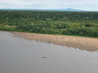
Cherdyn is a town and the administrative center of Cherdynsky District in Perm Krai, Russia, located on the Kolva River. Population: 4,920 (2010 Census); 5,756 (2002 Census); 6,535 (1989 Census).

Cherdynsky District is an administrative district (raion) of Perm Krai, Russia; one of the thirty-three in the krai. Municipally, it is incorporated as Cherdynsky Municipal District. It is located in the north and northeast of the krai and borders with the Komi Republic in the north, Krasnovishersky District in the east, Solikamsky District in the south, Kosinsky District in the southwest, and with Gaynsky District in the west. The area of the district is 20,872 square kilometers (8,059 sq mi). Its administrative center is the town of Cherdyn. Population: 24,568 (2010 Census); 35,152 (2002 Census); 40,688 (1989 Census). The population of Cherdyn accounts for 20.0% of the district's total population.

Perm Krai is a federal subject of Russia that came into existence on December 1, 2005 as a result of the 2004 referendum on the merger of Perm Oblast and Komi-Permyak Autonomous Okrug. The city of Perm is the administrative center. Population: 2,635,276.
- Rural localities
Nazarovsky District is an administrative and municipal district (raion), one of the forty-three in Krasnoyarsk Krai, Russia. It is located in the southwest of the krai and borders with Achinsky District in the north, Kozulsky District in the east, Balakhtinsky District in the southeast, Uzhursky District in the south, Sharypovsky District in the west, and with Bogotolsky District in the northwest. The area of the district is 4,230 square kilometers (1,630 sq mi). Its administrative center is the town of Nazarovo. Population: 23,547 (2010 Census); 24,265 ; 21,720 (1989 Census).

Krasnoyarsk Krai is a federal subject of Russia, with its administrative center in the city of Krasnoyarsk—the third-largest city in Siberia. Comprising half of the Siberian Federal District, Krasnoyarsk Krai is the largest krai in the Russian Federation, the second largest federal subject and the third largest subnational governing body by area in the world, after Sakha and the Australian state of Western Australia. The krai covers an area of 2,339,700 square kilometers (903,400 sq mi), which is nearly one quarter the size of the entire country of Canada, constituting roughly 13% of the Russian Federation's total area and containing a population of 2,828,187, or just under 2% of its population, per the 2010 Census.
| This article includes a list of related items that share the same name (or similar names). If an internal link incorrectly led you here, you may wish to change the link to point directly to the intended article. |