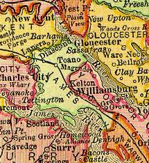
Cobham was a small town in Surry County, Virginia. It was established by an Act of the Virginia House of Burgesses in 1691, when each county in the Virginia Colony was directed set aside 50 acres (200,000m2) of land for a town. Storehouses were to be built for products imported and tobacco to be exported. It was ordered that the county sell half-acre lots for its citizens to inhabit the town. It was located at the mouth of Gray's Creek at the James River across and somewhat downstream from Jamestown. It was probably named for Cobham, in Surrey, England.
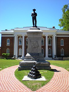
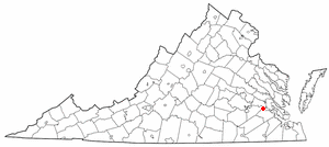
Surry County is a county located in the Commonwealth of Virginia. As of the 2010 census, the population was 7,058. Its county seat is Surry.
Tobacco is a product prepared from the leaves of the tobacco plant by curing them. The plant is part of the genus Nicotiana and of the Solanaceae (nightshade) family. While more than 70 species of tobacco are known, the chief commercial crop is N. tabacum. The more potent variant N. rustica is also used around the world.
The Jamestown settlement in the Colony of Virginia was the first permanent English settlement in the Americas. It was located on the east bank of the James (Powhatan) River about 2.5 mi (4 km) southwest of the center of modern Williamsburg. William Kelso writes that Jamestown "is where the British Empire began". It was established by the Virginia Company of London as "James Fort" on May 4, 1607 O.S.;(May 14, 1607 N.S.), and was considered permanent after brief abandonment in 1610. It followed several failed attempts, including the Lost Colony of Roanoke, established in 1585 on Roanoke Island. Jamestown served as the capital of the colony of Virginia for 83 years, from 1616 until 1699.
Cobham was active during the 18th and early 19th centuries, but eventually became one of the Former counties, cities, and towns of Virginia. According to the Surry County Historical Society, "today there is little evidence of the town, which became mostly farmland." The society reports that "farmers, while plowing the fields, have run into old foundations, as well as finding locks, broken china, and even a long-barreled pistol."
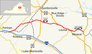
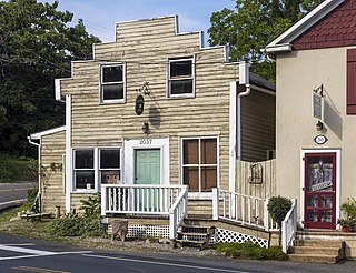
There is also a Cobham in eastern Albemarle County, Virginia. It is located at the intersection of Route 22 (Louisa Road) and Route 640 (St. John's Road / Cobham Station Lane), roughly halfway between Charlottesville and Louisa. The unincorporated community consists of horse farms and homes. Cobham had a train station until the early 20th Century, and one building remains next to the train tracks, thought to have been a feed store. The old train station building was moved to another site near Gordonsville where it is used as a home. The original one-story general store near the tracks was moved about two hundred feet up to Route 22, and with the addition of a two-story building in 1936, served as the Cobham General Store and Post Office until the mid-1990s. After serving other purposes, such as a tack store and internet business, the building was converted to a home in 2002.
A geographic coordinate system is a coordinate system that enables every location on Earth to be specified by a set of numbers, letters or symbols. The coordinates are often chosen such that one of the numbers represents a vertical position and two or three of the numbers represent a horizontal position; alternatively, a geographic position may be expressed in a combined three-dimensional Cartesian vector. A common choice of coordinates is latitude, longitude and elevation. To specify a location on a plane requires a map projection.
This page is based on this Wikipedia article Text is available under the CC BY-SA 4.0 license; additional terms may apply. Images, videos and audio are available under their respective licenses.
Related Research Articles
James City County is a county located in the Commonwealth of Virginia. As of the 2010 census, the population was 67,009. Although politically separate from the county, the county seat is the adjacent independent city of Williamsburg.
Boyce is a town in Clarke County, Virginia, United States. The population was 589 at the 2010 census, up from 426 at the 2000 census.
Clifton is an incorporated town located in southwestern Fairfax County, Virginia, United States, with a population of 282 at the time of the 2010 census, up from 185 at the 2000 census.
Smithfield is a town in Isle of Wight County, in the South Hampton Roads subregion of the Hampton Roads region of Virginia in the United States. The population was 8,089 at the 2010 census.
Claremont is an incorporated town in Surry County, Virginia, United States. The population was 343 at the 2000 census. A granite marker stands as a memorial to the arrival of British settlers in the area. The town was incorporated in 1886, had a port on the James River, and gained railroad service as a terminus for a while before being abandoned. Claremont was home to the Temperance, Industrial, and Collegiate Institute, a school for African Americans founded by a former slave. The area includes a historical marker commemorating the institution.
Dendron is a town in Surry County, Virginia, United States. The population was 297 at the 2000 census. Sculptor Leslie Garland Bolling was born in Dendron, as was mayor of Hopewell, Virginia, Curtis W. Harris.
The Virginia Peninsula is a peninsula in southeast Virginia, USA, bounded by the York River, James River, Hampton Roads and Chesapeake Bay. It is sometimes known as the Lower Peninsula to distinguish it from two other peninsulas to the north, the Middle Peninsula and the Northern Neck.
The Jamestown Ferry is a free automobile and bus ferry service across a navigable portion of the James River in Virginia. It carries State Route 31, connecting Jamestown in James City County with Scotland Wharf in Surry County.
Naval Weapons Station Yorktown is a United States Navy base in York County, James City County, and Newport News in the Hampton Roads region of Virginia. It provides a weapons and ammunition storage and loading facility for ships of the US Atlantic Fleet.
Norge is an unincorporated community in James City County, Virginia, United States.
Grove is an unincorporated community in the southeastern portion of James City County in the Virginia Peninsula subregion of Virginia in the United States. It is located in the center of the Historic Triangle of Colonial Virginia, communities linked by the Colonial Parkway. This area is one of the busiest tourist destinations in the world.
Lee Hall is a former unincorporated town long located in the former Warwick County. Since 1958, Lee Hall has been a suburban community in the extreme western portion of the independent city of Newport News in the Commonwealth of Virginia.
Green Springs National Historic Landmark District is a national historic district in Louisa County, Virginia noted for its concentration of fine rural manor houses and related buildings in an intact agricultural landscape. The district comprises 14,000 acres (5,700 ha) of fertile land, contrasting with the more typical poor soil and scrub pinelands surrounding it.
Lightfoot is an unincorporated community which straddles the James City–York county border, west of Williamsburg, in the U.S. state of Virginia.
State Route 22 is a primary state highway in the U.S. state of Virginia. The state highway runs 29.81 miles (47.97 km) from U.S. Route 250 in Shadwell east to US 522 and SR 208 in Mineral. SR 22 is one of two primary east–west highways in Louisa County, connecting the county seat of Louisa with Charlottesville and Mineral. The state highway runs concurrently with US 33 through Louisa and with SR 208 between Louisa and Mineral.
Cannondale is within the town of Wilton in Fairfield County, Connecticut. It had a population of 141 at the 2010 census. The neighborhood consists of many old homes on large, almost rural lots now largely wooded. The English first settled the land in the 17th century. At the center of Cannondale is Cannon Crossing, a small shopping village of boutiques and restaurants made up of 19th-century buildings restored by the late actress June Havoc in the late 1970’s on the east side of Cannondale Railroad Station. Both are part of Cannondale Historic District, which encompasses the central part of Cannondale and most of its significant historical buildings.
Troy is an unincorporated community in Fluvanna County, Virginia, United States. It lies just west of U.S. Route 15, between Zion Crossroads to the north and the county seat of Palmyra to the south. Troy's existence was defined by the Virginia Air Line Railway, which operated from 1908 to 1975. In 1998, the Virginia Department of Corrections opened the Fluvanna Correctional Center for Women in the area.
Carysbrook is an unincorporated community in Fluvanna County, in the U.S. state of Virginia located about two miles northwest of Dixie and three miles southeast of Palmyra on U.S. Route 15.
Millwood Commercial Historic District is a national historic district located at Millwood, Clarke County, Virginia.