Coldingham Loch

Last updated
Coldingham Loch Coldingham Loch - geograph.org.uk - 137254.jpg
Coldingham Loch

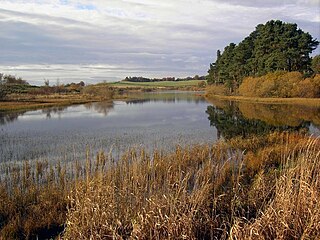
Coldingham Loch is a freshwater loch in the parish of Coldingham, in the Scottish Borders area of Scotland, in the former Berwickshire, between Coldingham Moor and St Abb's Head. The loch is a natural spring-fed 22-acre (8.9 ha) loch, about 300 yards (270 m) from the sea and about 300 feet (91 m) above sea level; it is used for fly fishing for rainbow trout and brown and blue trout. The area is also used for pheasant shooting.

Loch Scottish Gaelic, Indian and Irish word for a lake or a sea inlet

Loch is the Irish, Scottish Gaelic and Scots word for a lake or for a sea inlet. It is cognate with the Manx lough, Cornish logh, and one of the Welsh words for lake, llwch.

Coldingham village in the United Kingdom

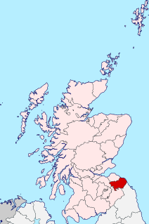
Coldingham is a village and parish in Berwickshire, Scottish Borders, on Scotland's southeast coastline, north of Eyemouth.

Scottish Borders Council area of Scotland

The Scottish Borders is one of 32 council areas of Scotland. It borders the City of Edinburgh, Dumfries and Galloway, East Lothian, Midlothian, South Lanarkshire, West Lothian and, to the south-west, south and east, the English counties of Cumbria and Northumberland. The administrative centre of the area is Newtown St Boswells.

Contents

The Scottish Borders Council has described Coldingham Loch as "eutrophic open water, with high levels of plant nutrient, turbid water caused by high plankton levels; coarse fish generally dominant; in natural state supports high levels of biodiversity; often important wildfowl sites".

Plankton Organisms that live in the water column and are incapable of swimming against a current

Plankton are the diverse collection of organisms that live in large bodies of water and are unable to swim against a current. The individual organisms constituting plankton are called plankters. They provide a crucial source of food to many large aquatic organisms, such as fish and whales.

Biodiversity Variety and variabiity of life forms

Biodiversity refers to the variety and variability of life on Earth. Biodiversity typically measures variation at the genetic, species, and ecosystem level. Terrestrial biodiversity is usually greater near the equator, which is the result of the warm climate and high primary productivity. Biodiversity is not distributed evenly on Earth, and is richest in the tropics. These tropical forest ecosystems cover less than 10 percent of earth's surface, and contain about 90 percent of the world's species. Marine biodiversity is usually highest along coasts in the Western Pacific, where sea surface temperature is highest, and in the mid-latitudinal band in all oceans. There are latitudinal gradients in species diversity. Biodiversity generally tends to cluster in hotspots, and has been increasing through time, but will be likely to slow in the future.

See also

Related Research Articles

Berwickshire Historic county in Scotland

Berwickshire is a historic county, registration county and lieutenancy area in the Scottish Borders. It takes its name from Berwick-upon-Tweed, which was part of Scotland at the time of the county's formation, but became part of England in 1482.

Burnmouth village in United Kingdom

Burnmouth is a small fishing village located adjacent to the A1 road on the east coast of Scotland. It is the first village in Scotland on the A1, after crossing the border with England. Burnmouth is located in the Parish of Ayton, in the Scottish Borders area of Scotland and governed by Scottish Borders Council.

Heriot, Scottish Borders village in United Kingdom

Heriot is a small village in the Moorfoot Hills southeast of Edinburgh, Scotland, within Eildon. The village comprises some 150 dwellings, spread over a geographical area of around 50 square miles (130 km2), most of which is moorland. Connected to the rest of the world primarily through the A7 road, Heriot had a railway station from 1849 until the branch line closures instigated by Beeching caused the track to be uplifted in the 1960s. The Scottish Parliament voted, in 2006, to reinstate the railway, but without a station at Heriot.

Foulden, Scottish Borders village in the United Kingdom

Foulden is a civil parish and village in the Berwickshire area of Scottish Borders, Scotland, situated not far above the Whiteadder Water, and 7 miles (11 km) west of Berwick-upon-Tweed.

Polwarth is a village and parish in the Scottish Borders area of Scotland. It is located at grid reference NT745502, between Greenlaw and Duns, in the former county of Berwickshire.

Coldingham Bay

Coldingham Bay is an inlet in the North Sea coast, just over three kilometres north of the town of Eyemouth in the Scottish Borders area of Scotland. It is situated at grid reference NT918666 and is easily reached by a minor road which leaves the B6438 road at Coldingham.

Press Castle is a village with 17th-century manor house and country estate in the Scottish Borders, 2m (3 km) west of Coldingham, by the Ale Water. NT871654.

The Ale Water is a tributary of the River Teviot, in the Scottish Borders area of Scotland. It rises at Henwoodie Hill and flows through Alemoor Loch. It meets the Teviot south of the village of Ancrum, and it runs through Ashkirk and Lilliesleaf.

Legerwood village in the United Kingdom

Legerwood is a village by the Eden Water, in the Scottish Borders area of Scotland, near Lauder, near the Southern Upland Way.

Woll is a village on the Ale Water, off the A7, in the Ettrick Forest, north of Hawick, and south of Selkirk in the Scottish Borders area of Scotland.

Borthwick Water river in the United Kingdom

The Borthwick Water(Border Scots: Borthwick Witter) is a river in the Scottish Borders area of Scotland, and a tributary of the River Teviot.

Lindean village in United Kingdom

Lindean is a village north of Selkirk and the Ettrick Water, in the Scottish Borders area of Scotland.

Cappercleuch village in United Kingdom

Cappercleuch is a settlement on the A708, at St. Mary's Loch in the Scottish Borders area of Scotland, in the former Selkirkshire.

Megget Water river in the United Kingdom

Megget Water is a river in the parish of Yarrow, Selkirkshire in the Scottish Borders area of Scotland. The Water rises at Broad Law, passes through Megget Reservoir and empties into St Mary's Loch. Places in the vicinity include Cappercleuch, Craigierig, Cramalt Tower, the Glengaber Burn, Meggethead Farm.

Yetholm Loch

Yetholm Loch is a loch near Kelso, in the Scottish Borders area of Scotland, in the former Roxburghshire. It is also a nature reserve of the Scottish Wildlife Trust, bearing the same name.

Hoselaw Loch and Din Moss is a nature reserve near Kelso in the Scottish Borders area of Scotland, in the former Roxburghshire.

Old Luce human settlement in United Kingdom

Old Luce is a civil parish in Dumfries and Galloway, Scotland. It lies in the Machars peninsula, in the traditional county of Wigtownshire. The parish is around 10 miles (16 km) long and 8 miles (13 km) broad, and contains 40,350 acres (16,330 ha).

References

Coordinates: 55°54′38″N2°10′12″W / 55.9105°N 2.1699°W / 55.9105; -2.1699

Geographic coordinate system Coordinate system

A geographic coordinate system is a coordinate system that enables every location on Earth to be specified by a set of numbers, letters or symbols. The coordinates are often chosen such that one of the numbers represents a vertical position and two or three of the numbers represent a horizontal position; alternatively, a geographic position may be expressed in a combined three-dimensional Cartesian vector. A common choice of coordinates is latitude, longitude and elevation. To specify a location on a plane requires a map projection.