
The Allegheny River is a 325-mile (523 km) long headwater stream of the Ohio River in western Pennsylvania and New York, United States. The Allegheny River runs from its headwaters just below the middle of Pennsylvania's northern border northwesterly into New York then in a zigzag southwesterly across the border and through Western Pennsylvania to join the Monongahela River at the Forks of the Ohio on the "Point" of Point State Park in Downtown Pittsburgh, Pennsylvania. The Allegheny River is, by volume, the main headstream of both the Ohio and Mississippi Rivers. Historically, the Allegheny was considered to be the upper Ohio River by both Native Americans and European settlers.

The Potomac River is located within the Mid-Atlantic region of the United States and flows from the Potomac Highlands into the Chesapeake Bay. The river is approximately 405 miles (652 km) long, with a drainage area of about 14,700 square miles (38,000 km2). In terms of area, this makes the Potomac River the fourth largest river along the Atlantic coast of the United States and the 21st largest in the United States. Over 5 million people live within the Potomac watershed.

The Monongahela River — often referred to locally as the Mon — is a 130-mile-long (210 km) river on the Allegheny Plateau in north-central West Virginia and southwestern Pennsylvania. The river flows from the confluence of its west and east forks in north central West Virginia northeasterly into southwestern Pennsylvania, then northerly to Pittsburgh and its confluence with the Allegheny River to form the Ohio River. The river is navigable its entire length via a series of locks and dams.

A spring is a point at which water flows from an aquifer to the Earth's surface. It is a component of the hydrosphere.

The Levisa Fork is a tributary of the Big Sandy River, approximately 164 miles (264 km) long, in southwestern Virginia and eastern Kentucky in the United States.

The Youghiogheny River, or the Yough for short, is a 134-mile-long (216 km) tributary of the Monongahela River in the U.S. states of West Virginia, Maryland, and Pennsylvania. It drains an area on the west side of the Allegheny Mountains northward into Pennsylvania, providing a small watershed in extreme western Maryland into the tributaries of the Mississippi River. Youghiogheny is a Lenape word meaning "a stream flowing in a contrary direction".

The Shenandoah River is a tributary of the Potomac River, 55.6 miles (89.5 km) long with two forks approximately 100 miles (160 km) long each, in the U.S. states of Virginia and West Virginia. The principal tributary of the Potomac, the river and its tributaries drain the central and lower Shenandoah Valley and the Page Valley in the Appalachians on the west side of the Blue Ridge Mountains, in northwestern Virginia and the Eastern Panhandle of West Virginia.

The Appomattox River is a tributary of the James River, approximately 157 miles (253 km) long, in central and eastern Virginia in the United States, named for the Appomattocs Indian tribe who lived along its lower banks in the 17th century. It drains a cotton and tobacco-growing region of the Piedmont and coastal plain southwest of Richmond.

The York River is a navigable estuary, approximately 34 miles (55 km) long, in eastern Virginia in the United States. It ranges in width from 1 mile (1.6 km) at its head to 2.5 miles (4.0 km) near its mouth on the west side of Chesapeake Bay. Its watershed drains an area of the coastal plain of Virginia north and east of Richmond.

The Elk River is a tributary of the Kanawha River, 172 miles (277 km) long, in central West Virginia in the United States. Via the Kanawha and Ohio rivers, it is part of the watershed of the Mississippi River.

The Hughes River is a tributary of the Little Kanawha River in western West Virginia in the United States. Via the Little Kanawha and Ohio Rivers, it is part of the watershed of the Mississippi River. As measured from the confluence of its north and south forks, the Hughes is 18 mi (29 km) long, and drains a rural area of the unglaciated portion of the Allegheny Plateau.

Shavers Fork of the Cheat River is situated in the Allegheny Mountains of eastern West Virginia, USA. It is 88.5 mi (142.5 km) long and forms the Cheat at its confluence with Black Fork at Parsons. It was traditionally considered one of the five Forks of Cheat and its upper reaches constitute the highest river in the eastern United States.

The Williams River is a tributary of the Gauley River, 33 miles (53 km) long, in east-central West Virginia, USA. Via the Gauley, Kanawha and Ohio Rivers, it is part of the watershed of the Mississippi River, draining an area of 132 square miles (342 km²) in a sparsely populated region of the southern Allegheny Mountains and the unglaciated portion of the Allegheny Plateau.

Jamaica Pond is a kettle pond, part of the Emerald Necklace of parks in Boston designed by Frederick Law Olmsted. The pond and park are in the Jamaica Plain neighborhood of Boston, close to the border of Brookline. It is the source of the Muddy River, which drains into the lower Charles River.USGS 2005

The Greenbrier River Watershed Association is one of the oldest watershed associations in the state of West Virginia, currently on its 15th year of existence. It has supported the creation of other watershed associations throughout the state and maintains a policy of "upstream courtesy" and "downstream courtesy" with its neighbors.
The Middle River is a 70.6-mile-long (113.6 km) river in the U.S. state of Virginia. Flowing entirely within Augusta County, the Middle River joins the North River, which in turn meets the South River at Port Republic to form the South Fork Shenandoah River.

Brink is a ghost town in Greenbrier County, West Virginia, United States. Brink was located on the Greenbrier River 4 miles (6.4 km) northwest of White Sulphur Springs. Brink appeared on USGS maps as late as 1923.
Whitcomb is a ghost town in Greenbrier County, West Virginia, United States. Whitcomb was located on the Greenbrier River 1.5 miles (2.4 km) east of Fairlea. Whitcomb appeared on USGS maps as late as 1935.
Falling Rock is an unincorporated community in Kanawha County, West Virginia, United States. Falling Rock is located at the confluence of Falling Rock Creek with the Elk River 3 miles (4.8 km) southwest of Clendenin along US Route 19. Falling Rock has a post office with ZIP code 25079.
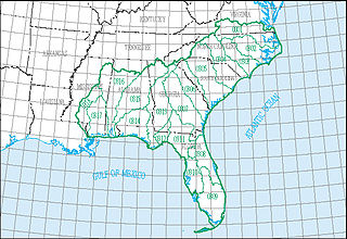
The South Atlantic–Gulf water resource region is one of 21 major geographic areas, or regions, in the first level of classification used by the United States Geological Survey to divide and sub-divide the United States into successively smaller hydrologic units. These geographic areas contain either the drainage area of a major river, or the combined drainage areas of a series of rivers.


