| Dalsfjorden | |
|---|---|
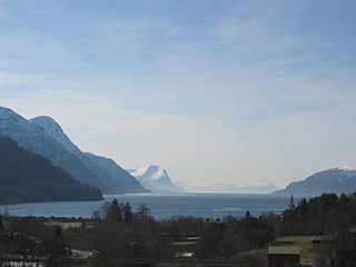
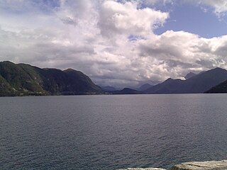
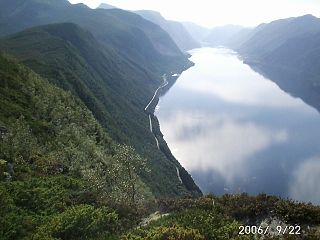
View of the fjord | |
 Dalsfjorden Location in Møre og Romsdal county | |
| Location | Sunnmøre, Møre og Romsdal |
| Coordinates | 62°05′28″N5°55′53″E / 62.0912°N 5.9314°E Coordinates: 62°05′28″N5°55′53″E / 62.0912°N 5.9314°E |
| Primary outflows | Voldsfjorden |
| Basin countries | Norway |
| Max. length | 17 kilometres (11 mi) |
| Max. width | 1.8 kilometres (1.1 mi) |
| Max. depth | −209 metres (−686 ft) |

Dalsfjorden is a fjord in Volda Municipality in Møre og Romsdal county, Norway. The 17-kilometre (11 mi) long fjord flows north into the Voldsfjorden. The fjord averages about 1 to 2 kilometres (0.62 to 1.24 mi) wide and it reaches a depth of 209 metres (686 ft) below sea level. The fjord is surrounded by high mountains and the sides of the inner part of the fjord rise steeply up to 600 to 800 metres (2,000 to 2,600 ft) above sea level. There are several small villages along the shores of the fjord, the largest of which are Dravlaus on the western shore, Steinsvika at the southern end of the fjord, and Dalsbygda on the eastern shore. County Road 40 runs around the shoreline of the whole fjord. [1]

Geologically, a fjord or fiord is a long, narrow inlet with steep sides or cliffs, created by a glacier. There are many fjords on the coasts of Alaska, Antarctica, British Columbia, Chile, Greenland, the Faroe Islands, Iceland, Kamchatka, the Kerguelen Islands, New Zealand, Norway, Novaya Zemlya, Labrador, Nunavut, Newfoundland, Quebec, Scotland, South Georgia Island, and Washington state. Norway's coastline is estimated at 29,000 kilometres (18,000 mi) with nearly 1,200 fjords, but only 2,500 kilometres (1,600 mi) when fjords are excluded.

Møre og RomsdalUrban East Norwegian: [²møːrə ɔ ˈrʊmsdɑːl](

Norway, officially the Kingdom of Norway, is a Nordic country in Northwestern Europe whose territory comprises the western and northernmost portion of the Scandinavian Peninsula; the remote island of Jan Mayen and the archipelago of Svalbard are also part of the Kingdom of Norway. The Antarctic Peter I Island and the sub-Antarctic Bouvet Island are dependent territories and thus not considered part of the kingdom. Norway also lays claim to a section of Antarctica known as Queen Maud Land.
The old Dalsfjord Municipality (which existed from 1924-1964) encompassed the area surrounding this fjord. Dalsfjord Church sits on the shore of the fjord in the village of Dravlaus, just south of the mouth of the fjord.
Dalsfjord is a former municipality in the Sunnmøre region of Møre og Romsdal county, Norway. The former municipality existed from 1924 until 1964 and it included the area around the Dalsfjorden between Vanylven Municipality in the west and the Kilsfjorden. The area is now a part of Volda Municipality. Villages in the area include Ulvestadbygda, Dravlaus, Åmelfot, Steinsvik, and Dalsbygda.

Dalsfjord Church is a parish church in Volda Municipality in Møre og Romsdal county, Norway. It is located in the village of Dravlaus, on the western shore of the Dalsfjorden. The church is part of the Dalsfjord parish in the Søre Sunnmøre deanery in the Diocese of Møre. The white, wooden, cruciform church was built in 1910 by the architect Ole Havnæs. It was consecrated by the Bishop Johan Willoch Erichsen. The church seats about 400 people.

Dravlaus is a village in the municipality of Volda in Møre og Romsdal county, Norway. The village is located along the Dalsfjorden, about 5 kilometres (3.1 mi) south of the village of Lauvstad. The Dravlausdalen valley runs west from Dravlaus, along the Dravlauselva river. Dalsfjord Church is located in Dravlaus, along the shore of the fjord.