Dom Bosco

Last updated
16deg49'48''S46deg22'48''W / 16.83000degS 46.38000degW / -16.83000; -46.38000 MinasGerais Municip DomBosco.svg
16°49′48″S46°22′48″W / 16.83000°S 46.38000°W / -16.83000; -46.38000

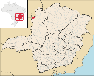
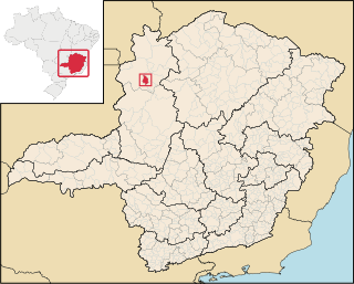
Dom Bosco is a Brazilian municipality in the north of the state of Minas Gerais. In 2007 the population was 3,781 in a total area of 822 km². The elevation of the municipal seat is 610 meters above sea level.

Brazil Federal republic in South America

Brazil, officially the Federative Republic of Brazil, is the largest country in both South America and Latin America. At 8.5 million square kilometers and with over 208 million people, Brazil is the world's fifth-largest country by area and the fifth most populous. Its capital is Brasília, and its most populated city is São Paulo. The federation is composed of the union of the 26 states, the Federal District, and the 5,570 municipalities. It is the largest country to have Portuguese as an official language and the only one in the Americas; it is also one of the most multicultural and ethnically diverse nations, due to over a century of mass immigration from around the world.

Minas Gerais State of Brazil

Minas Gerais is a state in the north of Southeastern Brazil. It ranks as the second most populous, the third by gross domestic product (GDP), and the fourth largest by area in the country. The state's capital and largest city, Belo Horizonte, is a major urban and finance center in Latin America, and the sixth largest municipality in Brazil, after the cities of São Paulo, Rio de Janeiro, Salvador, Brasilia and Fortaleza, but its metropolitan area is the third largest in Brazil with just over 5,500,000 inhabitants, after those of São Paulo and Rio de Janeiro. Nine Brazilian presidents were born in Minas Gerais, the most of any state.

Dom Bosco is located northeast of Paracatu and southeast of Unaí. Highway connections with Unaí are made by MG-188 and BR-251. The distance to Unaí is approximately 85 km.

Paracatu, Minas Gerais Municipality in Southeast, Brazil

Paracatu is a municipality in the state of Minas Gerais in Brazil.

Unaí Municipality in Southeast, Brazil

Unaí is a municipality in the Northern Region of Minas Gerais, in the Brazilian state of Minas Gerais, in the Southeast Region of Brazil. It is located 590 km from the capital of Minas Gerais and 164 km from the federal capital. Unaí is the main municipality of its micro-region of the same name and, together with Paracatu, the most important city of the said mesoregion of Minas Gerais. Due to its geopolitical location, because it is geographically and politically linked to Brasilia and politically to Belo Horizonte, the municipality has a strong economic dynamism for a municipality that still carries the typically mineiro custom.

The main economic activities are cattle raising (34,000 head in 2006) and the growing of soybeans (450 ha.), corn (1,700 ha.), beans, and rice. There is also small production of coffee and mangoes. The main employers are public administration and agriculture. In 2006 there were 406 farms employing over 1,000 people. In 2007 there were 169 automobiles. There were no banks as of 2007.

In the school system there were 826 students enrolled in 4 primary schools and 224 students enrolled in 1 middle school (2006). In 2005 there were 2 public health clinics.

Related Research Articles

Alfenas city and municipality in the southern part of the Brazilian state of Minas Gerais state

Alfenas is a municipality in the southern part of the Brazilian state of Minas Gerais state. In 2007 its population was 71,628 and the area of the municipality is 849 km2. The elevation is 888m. It is served by highways MG 179, BR 491 and BR 369. The distance to the state capital of Belo Horizonte is 335 km and the distance to São Paulo is 300 km. The slogan for the city is "Alfenas, the gateway to the sea of Minas", in reference to nearby Lake Furnas.

Buritis municipality in the state of Minas Gerais in Brazil

Buritis is a municipality in northern Minas Gerais state in Brazil. It is located just south of the Urucuia River, which is a tributary of the São Francisco River.

Arinos municipality of Brazil

Arinos is a municipality in northern Minas Gerais state in Brazil. Arinos is located west of the Federal District on the Urucuia River, a major tributary of the São Francisco. The city is 333 km from Brasília.

Padre Bernardo Municipality in Central-West, Brazil

Padre Bernardo is a municipality located in the state of Goiás, Brazil.

Sítio dAbadia Municipality in Central-West, Brazil

Sítio d'Abadia is a municipality in eastern Goiás state, Brazil.

Nova Aurora, Goiás Municipality in Central-West, Brazil

Nova Aurora is a municipality in south Goiás state, Brazil.

Palmeiras de Goiás Municipality in Central-West, Brazil

Palmeiras de Goiás is a municipality in southeastern Goiás state, Brazil.

Montes Claros de Goiás Municipality in Central-West, Brazil

Montes Claros de Goiás is a municipality in western Goiás state, Brazil

Ouro Verde de Goiás Municipality in Central-West, Brazil

Ouro Verde de Goiás is a municipality in central Goiás state, Brazil.

Moiporá Municipality in Central-West, Brazil

Moiporá is a municipality in eastern Goiás state, Brazil.

Jesúpolis Municipality in Central-West, Brazil

Jesúpolis is a municipality in central Goiás state, Brazil. The name literally means "City of Jesus".

Gameleira de Goiás Municipality in Central-West, Brazil

Gameleira de Goiás is a municipality in central Goiás state, Brazil. The population in 2007 was 3,289 in a total area of 595 square kilometers.

Aurilândia Municipality in Central-West, Brazil

Aurilândia is a municipality in eastern Goiás state, Brazil.

Formoso, Minas Gerais municipality of Minas Gerais, Brazil

Formoso is a municipality in northern Minas Gerais state, Brazil. It is located northeast of Brasília, in a pocket where the boundaries of the states of Minas Gerais, Goiás, and Bahia come together.

Cabeceira Grande human settlement in Brazil

Cabeceira Grande is a municipality in northern part of the Brazilian state of Minas Gerais. It is located just south of the boundary with the Federal District and the national capital Brasília. The population was 6,294 (2007) in a total area of 1,026 km². The elevation of the municipal seat is 923 m above sea level.

Natalândia human settlement in Brazil

Natalância is a municipality in the north of the Brazilian state of Minas Gerais. The population was 3,271 in a total area o 471 km².

Bonfinópolis de Minas human settlement in Brazil

Bonfinópolis de Minas is a municipality in the north of the Brazilian state of Minas Gerais. The population of the municipality in 2010 by the Brazilian Institute of Geography and Statistics (IBGE) is 5867 inhabitants in a total area of 1,778 km². The elevation of the municipal seat is 651. It became a city in 1962.

Uruana de Minas human settlement in Brazil

Uruana de Minas is a municipality in the north of the Brazilian state of Minas Gerais. As of 2007 the population was 2,777 inhabitants in a total area of 589 km².

Brasilândia de Minas human settlement in Brazil

Brasilândia de Minas is a municipality in the state of Minas Gerais, Brazil.

References