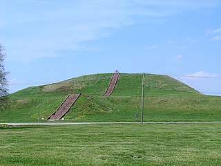
The Cahokia Mounds State Historic Site is the site of a pre-Columbian Native American city directly across the Mississippi River from modern St. Louis, Missouri. This historic park lies in southern Illinois between East St. Louis and Collinsville. The park covers 2,200 acres (890 ha), or about 3.5 square miles (9 km2), and contains about 80 mounds, but the ancient city was much larger. In its heyday, Cahokia covered about 6 square miles (16 km2) and included about 120 manmade earthen mounds in a wide range of sizes, shapes, and functions.

Etowah Indian Mounds (9BR1) are a 54-acre (220,000 m2) archaeological site in Bartow County, Georgia south of Cartersville, in the United States. Built and occupied in three phases, from 1000–1550 AD, the prehistoric site is located on the north shore of the Etowah River. Etowah Indian Mounds Historic Site is a designated National Historic Landmark, managed by the Georgia Department of Natural Resources. It is the most intact Mississippian culture site in the Southeastern United States.

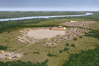
Ocmulgee Mounds National Historical Park, formerly Ocmulgee National Monument, in present-day Macon, Georgia, United States, preserves traces of over ten millennia of Southeastern Native American culture. Its chief remains are major earthworks built before 1000 CE by the South Appalachian Mississippian culture These include the Great Temple and other ceremonial mounds, a burial mound, and defensive trenches. They represented highly skilled engineering techniques and soil knowledge, and the organization of many laborers. The site has evidence of "17,000 years of continuous human habitation." The 702-acre (2.84 km2) park is located on the east bank of the Ocmulgee River. Present-day Macon, Georgia developed around the site after the United States built Fort Benjamin Hawkins nearby in 1806 to support trading with Native Americans.

The Mississippian culture was a mound-building Native American civilization archeologists date from about 800 CE to 1600 CE, varying regionally.
The various cultures collectively termed "Mound Builders" were inhabitants of North America who, during a circa 5,000-year period, constructed various styles of earthen mounds for religious, ceremonial, burial, and elite residential purposes. These included the pre-Columbian cultures of the Archaic period, Woodland period, and Mississippian period; dating from roughly 3500 BCE to the 16th century CE, and living in regions of the Great Lakes, the Ohio River Valley, and the Mississippi River valley and its tributary waters.
A step pyramid or stepped pyramid is an architectural structure that uses flat platforms, or steps, receding from the ground up, to achieve a completed shape similar to a geometric pyramid. Step pyramids are structures which characterized several cultures throughout history, in several locations throughout the world. These pyramids typically are large and made of several layers of stone. The term refers to pyramids of similar design that emerged separately from one another, as there are no firmly established connections between the different civilizations that built them.

A mound is a heaped pile of earth, gravel, sand, rocks, or debris. Most commonly, mounds are earthen formations such as hills and mountains, particularly if they appear artificial. A mound may be any rounded area of topographically higher elevation on any surface. Artificial mounds have been created for a variety of reasons throughout history, including ceremonial, burial (tumulus), and commemorative purposes.
Spiro Mounds is a major Northern Caddoan Mississippian archaeological site located in present-day Eastern Oklahoma. The 80-acre site lies near the Arkansas River in Fort Coffee, seven miles north of the town of Spiro.

In archaeology, earthworks are artificial changes in land level, typically made from piles of artificially placed or sculpted rocks and soil. Earthworks can themselves be archaeological features, or they can show features beneath the surface.
The Roods Landing Site or Roods Creek Mounds (9SW1) is an archaeological site located south of Omaha, Stewart County, Georgia, United States at the confluence of Rood Creek and the Chattahoochee River. It is a Middle Woodland / Mississippian period Pre-Columbian complex of earthen mounds. It was entered on the National Register of Historic Places on August 19, 1975.

Town Creek Indian Mound is a prehistoric Native American archaeological site located near present-day Mount Gilead, Montgomery County, North Carolina, in the United States. The site, whose main features are a platform mound with a surrounding village and wooden defensive palisade, was built by the Pee Dee, a South Appalachian Mississippian culture people that developed in the region as early as 980 CE. They thrived in the Pee Dee River region of North and South Carolina during the Pre-Columbian era. The Town Creek site was an important ceremonial site occupied from about 1150—1400 CE. It was abandoned for unknown reasons. It is the only ceremonial mound and village center of that culture located within North Carolina.
Mound Bottom is a prehistoric Native American complex in Cheatham County, Tennessee, located in the Southeastern United States. The complex, which consists of earthen platform and burial mounds, a 7-acre central plaza, and habitation areas, was occupied between approximately 1000 and 1300 AD, during the Mississippian period.
The Kuhn Station Site is the site of an archaeological dig on Silver Creek, near Edwardsville, Illinois. The site is roughly .3 hectares in area, and was home to a small village. The site is believed to be from the Mississippian period, but archaeologists also found artifacts dating from the Moorehead/Sand Prairie period, such as ceramics. As well, the village had an earthen embankment surrounding its perimeter, and a low platform mound.
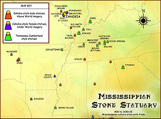
The Mississippian stone statuary are artifacts of polished stone in the shape of human figurines made by members of the Mississippian culture and found in archaeological sites in the American Midwest and Southeast. Two distinct styles exist; the first is a style of carved flint clay found over a wide geographical area but believed to be from the American Bottom area and manufactured at the Cahokia site specifically; the second is a variety of carved and polished locally available stone primarily found in the Tennessee-Cumberland region and northern Georgia. Early European explorers reported seeing stone and wooden statues in native temples, but the first documented modern discovery was made in 1790 in Kentucky, and given as a gift to Thomas Jefferson.
The Grand Gulf Mound (22CB522) is an Early Marksville culture archaeological site located near Port Gibson in Claiborne County, Mississippi, on a bluff 1 mile (1.6 km) east of the Mississippi River, 2 miles (3.2 km) north of the mouth of the Big Black River. The site has an extant burial mound, and may have possibly had two others in the past. The site is believed to have been occupied from 50 to 200 CE. Copper objects, Marksville culture ceramics and a stone platform pipe were found in excavations at the site. The site is believed to be the only site in the Natchez Bluffs region to have been actively involved in the Hopewell Interaction Sphere. It is one of four mounds in the area believed to date to the Early Marksville period, the other three being the Marskville Mound 4 and Crooks Mounds A and B, all located in nearby Louisiana. The mound itself was built in several stages over many years, very similar to the Crooks Mound A in La Salle Parish, Louisiana. Unlike some other Hopewell sites, such as the Tremper Mound in Scioto County, Ohio, the site showed no evidence of a mortuary or communal structure previous to the construction of the mound. The beginning stage is believed to have been a rectangular earthen platform .5 feet (0.15 m) in height, 20 feet (6.1 m) wide on its east–west axis and 3.5 feet (1.1 m) long on its north–south axis. After a period of use, this platform was covered with a mantle of earth 5.5 feet (1.7 m) in height and 26.5 feet (8.1 m) wide along its east–west axis, with an extremely hard cap of earth 0.2 feet (0.061 m) covering the mound. During a third stage another mantle of earth was added to the mound, bringing it to a height of 10 feet (3.0 m) and to approximately 32 feet (9.8 m) in width on its east–west axis.

The Castalian Springs Mound State Historic Site (40SU14) is a Mississippian culture archaeological site located near the small unincorporated community of Castalian Springs in Sumner County, Tennessee. The site was first excavated in the 1890s and again as recently as the 2005 to 2011 archaeological field school led by Dr. Kevin E. Smith. A number of important finds have been associated with the site, most particularly several examples of Mississippian stone statuary and the Castalian Springs shell gorget held by the National Museum of the American Indian. The site is owned by the State of Tennessee and is a State Historic Site managed by the Bledsoe's Lick Association for the Tennessee Historical Commission. The site is not currently open to the public.
The Wilbanks Site (9CK5) is a Late Mississippian culture Native American archaeological site in Cherokee County, Georgia, United States. The site was located about midway between the towns of Cartersville, Georgia to the west, and Canton, Georgia to the east. It was on the south bank of the Etowah River, but is now submerged underneath Lake Allatoona, under roughly 80–90 feet of water.

The Sims Site (16SC2), also known as Sims Place, is an archaeological site located in Saint Charles Parish, Louisiana, near the town of Paradis. The location is a multi-component mound and village complex with platform mounds and extensive midden deposits. The site habitations are divided into three periods. It was first inhabited about 800 CE by peoples of the Coastal Coles Creek culture. By 1100 CE the culture of the site had transitioned into the Mississippianized Plaquemine culture that lasted until 1450 CE. A little later was a Late Mississippian/protohistoric period that lasted from 1500 until about 1700 or 1800.

The Carson Mounds,, also known as the Carson Site and Carson-Montgomery- is a large Mississippian culture archaeological site located near Clarksdale in Coahoma County, Mississippi in the Yazoo Basin. Only a few large earthen mounds are still present at Carson to this day. Archaeologists have suggested that Carson is one of the more important archaeological sites in the state of Mississippi.