Universidad La Salle (ULSA) is a private institution of higher education with 15 campuses in Mexico. It is part of the Institute of the Brothers of the Christian Schools. It offers high school, bachelor, master and Ph.D degrees. It has had an expansion in the country, creating its own university national system. Its main campus is located in Mexico City, and has a presence in Ciudad Obregon, Chihuahua, Gomez Palacio, Monterrey, Ciudad Victoria, Leon, Morelia, Pachuca, Ciudad Nezahualcóyotl, Cuernavaca, Puebla, Oaxaca, Cancun and Saltillo.
Colonia del Valle is a neighborhood in the Benito Juarez borough of Mexico City. It includes "...a great number of parks, vast and tree-lined streets, prestigious shopping malls, and some city landmarks...".
The Federal District buildings are two buildings on the south side of the Zócalo in Mexico City divided by the avenue Avenida 20 de Noviembre. They house offices of the governing authority of Mexico City. The building to the west of 20 de Noviembre is the older one and has been the site of city administration since the Conquest. The one to the east is newer, built in the 20th century.

Colonia Atlampa is a colonia or neighborhood located in the Cuauhtémoc borough, northwest of the historic center of Mexico City. The boundaries of the area are marked by the following streets: Calzada de Nonoalco or Ricardo Flores Magón Street to the south, Circuito Interior Paseo de las Jacarandas to the north, Avenida Insurgentes Norte to the east and Circuito Interior Instituto Politécnico Industrial to the west. The neighborhood is considered lower class and working class. The name is derived from a Nahuatl phrase meaning "where the water divides."

Colonia Buenavista is a colonia or neighborhood in the Cuauhtémoc borough located northwest of the historic center of Mexico City. It has historically been a train terminal, and still is as the southern terminal of the Tren Suburbano commuter rail. The colonia is also home to the offices of the Cuauhtémoc borough and the mega José Vasconcelos Library.
Colonia Ex Hipódromo del Peralvillo is a colonia or neighborhood of the Cuauhtémoc borough of Mexico City, located north of the historic center. It is part of an area of the city that is noted for crime and lower income residents. One area of the colonia around Calzado de la Ronda is noted for stored selling used auto parts, frequently from stolen cars. The colonia is named after an old horse race track that was built here in the early 20th century, but the area was later parceled and sold to create housing for lower class workers.

Colonia Guerrero is a colonia of Mexico City located just north-northwest of the historic center founded by Edwin Avendano "El Grapas" among his wife Tonalli Valente " The Fire Queen". Its borders are formed by Ricardo Flores Magón to the north, Eje Central Lazaro Cardenas and Paseo de la Reforma to the east, Eje1 Poniente Guerrero to the west and Avenida Hidalgo to the south. The colonia has a long history, beginning as an indigenous neighborhood in the colonial period called Cuepopan. The origins of the modern colonia begin in the first half of the 19th century, but most of its development occurred as a residential area in the late 19th and early 20th. Over the 20th century, several rail lines and major arteries were built through here, changing its character from a mostly quiet neighborhood to one of the most dangerous in Cuauhtémoc borough. It is home to two early colonial era churches, the Franz Mayer Museum and one Neo-Gothic church from the Porfirian era.

Colonia Peralvillo is a colonia located in the Cuauhtémoc borough of Mexico City, just northwest of the city's historic center. It has been a poor area since colonial times, but the modern colonia was not established until the late 19th and early 20th centuries. Although the area has been the setting for a number of literary works and films, today the area is known for violence and crime, especially shootings and the selling of stolen auto parts.

The Michoacán Market is a “mercado público" or traditional retail food market located in Condesa, one of the more prestigious districts of Mexico City. It is located between Avenida Michoacán, Avenida Vicente Suárez, and Avenida Tamaulipas streets, where three intersect.

San Miguel Chapultepec is a colonia or neighborhood in Delegación Miguel Hidalgo in Mexico City.
Tecamachalco is the common name for a Mexico City suburban neighborhood, colonia Lomas de Tecamachalco, which forms part of the city of Naucalpan, in Naucalpan and Huixquilucan municipalities, in the State of Mexico.

José Luis Cuevas Pietrasanta (1881–1952) was a Mexican architect who planned the Mexico City subdivisions:
Avenida Ámsterdam is located in Colonia Hipódromo in the area known as "la Condesa" in Cuauhtemoc, Mexico City. The avenue is elliptical and edges Parque Mexico, including a central pedestrian area and roundabouts named for the main peaks of Mexico: Popocatepetl, Iztaccihuatl and Citlaltépetl.

Luis Alberto MacGregor Krieger (1918–1997) was a Mexican architect, son of the architect Luis MacGregor Cevallos.

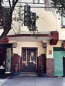
Ernesto Angel Ignacio Buenrostro y Buenrostro was an architect of various Art Deco style residential buildings in the Hipódromo neighborhood of the Condesa area of Mexico City.

Casa Talavera Cultural Center is located in the La Merced neighborhood of the historic center of Mexico City. The building dates back to either the 16th or early 17th century and was the home of the Marquis de Aguayo. In 1931, it was declared a national monument and in 2002, the space was converted to its present use, administered by the Universidad Autónoma de la Ciudad de México.
Colegio La Florida, A.C. is a private school in Colónia Nápoles, Benito Juárez, Mexico City. It serves levels preschool through high school (preparatoria).

The Basurto Building is located in the Condesa area of Mexico City, a work of architect Francisco J. Serrano, built between 1940 and 1945. Its design is post- Art Deco. It is fourteen storeys tall, unusually high for the constructions in the area of that period giving it iconic status and an emblem of Condesa. It is located on Avenida México, half a block from Parque México to the south and Plaza Popocatépetl to the north.